U.S. Route 163 is a 64-mile (103 km) U.S. Highway that runs from US 160 northward to US 191 in the U.S. states of Arizona and Utah. The southernmost 44 miles (71 km) of its length are within the Navajo Nation. The highway forms part of the Trail of the Ancients, a National Scenic Byway. The highway cuts through the heart of Monument Valley and has been featured in numerous movies and commercials.

U.S. Route 191 is a spur of U.S. Route 91 that has two branches. The southern branch runs for 1,465 miles (2,358 km) from Douglas, Arizona on the Mexican border to the southern part of Yellowstone National Park. The northern branch runs for 440 miles (710 km) from the northern part of Yellowstone National Park to Loring, Montana, at the Canada–US border. Unnumbered roads within Yellowstone National Park connect the two branches. The highway passes through the states of Arizona, Utah, Wyoming, and Montana.
State Route 201 (SR-201) is an east–west expressway and freeway located in Salt Lake County in the U.S. state of Utah. Colloquially known by some as the 21st South Freeway, the route serves as an alternative to Interstate 80 (I-80) through Salt Lake City. From the western terminus of the route west of Magna, the highway heads east through Kennecott Copper property as an expressway before running through the western suburbs of Salt Lake City as a freeway. Shortly after the route returns on a surface route, SR-201 terminates on its eastern end at State Street.

U.S. Route 89A is a 91.74-mile (147.64 km) north–south auxiliary U.S. highway in southwestern Kane County, Utah and northeastern Coconino County, Arizona in the southwestern United States. The highway is an old routing of U.S. Route 89 from Bitter Springs, Arizona to Kanab, Utah. The state of Arizona has designated this highway the Fredonia-Vermilion Cliffs Scenic Road. The highway is used to access Grand Canyon National Park and is known for the Navajo Bridge. Until 2008, the Utah portion was signed State Route 11.
U.S. Route 50 (US-50) in Utah crosses the center of the state. The highway serves no major population centers in Utah, with the largest city along its path being Delta. Most of the route passes through desolate, remote areas. Through the eastern half of the state the route is concurrent with Interstate 70 (I-70). US-50 both enters and exits Utah concurrent with US-6, however the two routes are separate through the center of the state.
State Route 8 (SR-8) is a short state highway in the southwestern portion of the U.S. state of Utah, running entirely within the city of St. George. The route connects SR-18 to Dixie Downs Road via Sunset Boulevard in a span of 1.3 miles (2.09 km). Prior to 1999, SR-8 extended north to Snow Canyon State Park. However, the route was truncated to its current point that year.
State Route 32 (SR-32) is a state highway in Wasatch and Summit Counties in the U.S. state of Utah. Most of the highway is an old routing of U.S. Route 189 that became disconnected from the rest of US-189 during the construction of the Jordanelle Reservoir. SR-32 runs for 29.053 miles (46.756 km) from US-40 and US-189 north of Heber City to I-80 near Wanship. Although signed US-189 or US-189 Alternate for most of its history, the highway pre-dates the creation of U.S. Highways and has had several numerical designations and route changes through the years.
Interstate 70 (I-70) is a mainline route of the Interstate Highway System in the United States connecting Utah and Maryland. The Utah section runs east–west for approximately 232 miles (373 km) across the central part of the state. Richfield is the largest Utah city served by the freeway, which does not serve or connect any urban areas in the state. The freeway was built as part of a system of highways connecting Los Angeles and the northeastern United States. I-70 was the second attempt to connect southern California to the east coast of the United States via central Utah, the first being a failed attempt to construct a transcontinental railroad. Parts of that effort were re-used in the laying out of the route of I-70.
State Route 161 (SR-161) is a 3.084-mile (4.963 km) long state highway, designated as a rural major connector, completely within Millard County in central Utah. The highway connects Interstate 70 (I-70) to I-15 while providing service to historic Cove Fort. The route was once part of U.S. Route 91 (US-91), but was renumbered to SR-161 in the 1970s, in parallel with the construction of I-70.
State Route 271 (SR-271) is a state highway within Iron County in the southwestern portion of the US state of Utah that connects Parowan and SR-274 to Paragonah and I-15. The route spans 5.65 miles (9.09 km) south–north and roughly parallels I-15. State Route 271 was designated in 1978.
State Route 120 (SR-120) is a state highway in the US state of Utah forming a business loop around I-70 serving the town of Richfield. The route forms the main street for Richfield and spans 3.89 miles (6.26 km). The highway was established 1969, coinciding with the construction of I-70 through Sevier County.
State Route 259 (SH-259) is a short state highway within Sigurd in Sevier County, Utah connecting Interstate 70 (I-70)/U.S. Route 89 (US-89) to SR-24.
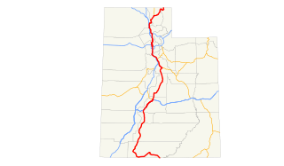
U.S. Route 89 in the U.S. state of Utah is a north–south United States Highway spanning more than 502 miles (807.891 km) through the central part of the state, making it the longest road in Utah. Between Provo and Brigham City, US-89 serves as a local road, paralleling Interstate 15, but the portions from Arizona north to Provo and Brigham City northeast to Wyoming serve separate corridors. The former provides access to several national parks and Arizona, and the latter connects I-15 with Logan, the state's only Metropolitan Statistical Area not on the Interstate.
State Route 72 (SR-72) is a 35.393-mile-long (56.960 km) state highway in the U.S. state of Utah. The current alignment is an extension of SR-10. The highway provides access to Loa from Interstate 70 (I-70).

State Route 152 (SR-152) is a state highway in the suburbs of Salt Lake City, Utah connecting SR-71 in Murray to I-215 and city-maintained Highland Drive in Cottonwood Heights, though for almost all of its length it forms the border between Murray and Holladay. The route, which is 3.04 miles (4.89 km), is laid on the entire length of the Van Winkle Expressway and a portion of Highland Drive.
State Route 273 (SR-273) is a state highway completely within Davis County in the northern portion of the U.S. state of Utah that connects Farmington and US-89 to Kaysville and I-15.
State Route 119 (SR-119) is a 8.753-mile-long (14.087 km) state highway in the U.S. state of Utah, connecting SR-119 in Richfield to SR-24 near Glenwood.

State Route 93 (SR-93) is a state highway in the US state of Utah providing a connection from I-15 to US-89. The highway is completely in the city limits of Woods Cross, spanning 0.37 miles (0.60 km). The entire route is routed along 2600 South. It was formed in 1965 coinciding with the construction of I-15 through the area. At the time of formation, the route at the eastern terminus was legislatively designated SR-106, though it was signed as US-89 and US-91. US-91 was decommissioned in 1974, and the designation of SR-106 changed to the signed route, US-89, in 1977.
State Route 103 (SR-103) is a 0.225-mile-long (362 m) urban minor arterial state highway in the U.S. state of Utah. It branches off from SR-126 in downtown Clearfield and extends east to Interstate 15 (I-15), with the roadway continuing to the Falcon Hill National Aerospace Research Park, just outside Hill Air Force Base. The entire route is located in Davis County and was formed in 1965 coinciding with the construction of I-15.
State Route 114 (SR-114) is a state highway in the US state of Utah that spans 10.79 miles (17.36 km) in Utah County. The route forms a loop around US-89 and roughly parallels the coast of Utah Lake as it passes through the west side of Provo, Lindon and Orem, eventually terminating in Pleasant Grove. The highway consists of a portion of Center Street and all of Geneva Road. The highway was formed in 1931, the southern terminus initially extending into the east side of Provo. In 1965, the route was truncated to its present state.

