U.S. Route 50 in Utah

Last updated

US 50.svg

U.S. Route 50

U.S. Route 50 in Utah
US 50 highlighted in red
Route information
Maintained by UDOT
Length335.541 mi [1]  (540.001 km)
Existed1926–present
Major junctions
West endUS 6.svgUS 50.svg US 6  / US 50 at the Nevada state line (east of Baker, NV)
Major intersectionsUS 6.svg US 6 in Delta
I-15.svg I-15 in Holden
I-15.svg I-15 in Scipio
I-70.svgUS 89.svg I-70  / US 89 in Salina
US 6.svgUS 191.svg US 6  / US 191 near Green River
US 191.svg US 191 at Crescent Junction
East endI-70.svgUS 6.svgUS 50.svg I-70  / US 6  / US 50 at the Colorado state line (west of Fruita, CO)
Location
Country United States
State Utah
Counties Millard, Sevier, Emery, Grand
Highway system
  • Utah State Highway System
Utah 48.svg SR-48 Utah 51.svg SR-51

U.S. Route 50 (US-50) in Utah crosses the center of the state. The highway serves no major population centers in Utah, with the largest city along its path being Delta. Most of the route passes through desolate, remote areas. Through the eastern half of the state the route is concurrent with Interstate 70 (I-70). US-50 both enters and exits Utah concurrent with US-6, however the two routes are separate through the center of the state.

Contents

Three completely different routings of US-50 have existed between Green River and Ely, Nevada. The route between these cities has become progressively shorter as new roads have been paved through this largely uninhabited region of both states. The earlier routings were a result of a dispute between Utah and Nevada over which auto trails would be paved and converted to U.S. Highways.

Route description

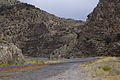
The highway enters Utah from Nevada in a desolate portion of the Great Basin Desert. Similar to many portions of the route in Nevada, there are multiple stretches without any motorist services. There are no services between the state line and the small farming village of Hinckley, just outside of Delta, a span of roadway that is about 100 miles (160 km). [2] While passing through the Great Basin the highway crosses two mountain ranges, the Confusion Range via King's Canyon, and House Range via Skull Rock Pass, before arriving at the shore of Sevier Lake, an intermittent lake fed by snow melt from many mountain ranges in the eastern half of the Great Basin. The highway follows the north shore of Sevier Lake and the Sevier River towards Delta. [2] Today much of the water in the Sevier river is diverted for agricultural use before reaching the lake, and rarely is significant water visible in the lake. [3]

The scenery changes as US-50 approaches Delta, where U.S. Route 6 and 50 separate. As the road approaches Delta, a straight passage across desert becomes zigzags through farming areas. The highway continues to zigzag through farms until arriving at more mountainous terrain at Holden. At Holden, the highway merges with Interstate 15 to cross the Pavant Range via Scipio Summit. After passing the mountains, US-50 then separates from this freeway as again a two lane road passing through desolate territory towards Salina where the road joins with Interstate 70. The two highways run concurrent from this point east to Colorado. Yet again, there is a stretch of highway 110 miles (180 km) long without services from Salina to Green River. [2]

While co-routed with I-70, US-50 crosses the Wasatch Plateau and passes through the San Rafael Swell. The construction of I-70 through the swell is noted as one of the engineering marvels of the Interstate Highway System. [4] One specific feat, the excavation through a portion called Spotted Wolf Canyon, required excavating 3,500,000 cubic yards (2,700,000 m3) of rock to have a bed for just 8 miles (13 km) of roadway. Construction workers noted that prior to the construction of the freeway a man could stand in this canyon and touch both sides of the canyon wall. [5]

US-6 rejoins US-50 near Green River. The three routes run concurrent and follow the southern edge of the Book Cliffs to Grand Junction, Colorado. Once again, services are not present from Thompson Springs to Fruita, Colorado, a span of about 60 miles (97 km). [2] This portion of US-50 is part of the Dinosaur Diamond Prehistoric Highway, a National Scenic Byway. The name of the byway comes from the large number of areas along the route with visible dinosaur remains. [6] The entire route through the state, as well as the concurrencies with I-15 and I-70, is included in the National Highway System. [7]

Photos

History

The modern route of U.S. Route 50 between Ely, Nevada and Green River, Utah is the third iteration.

First iteration

In 1926, when the U.S. Highway system was first announced, there was a gap in US-50 between Ely and Thistle. [8] At the time the states of Utah and Nevada were feuding about which of the old auto trails would be paved and used for the new U.S. Highway System. Nevada favored the Lincoln Highway, which the modern US-50 closely follows in that state. Utah refused to consider the Lincoln Highway west of Salt Lake City. Officials perceived that route would carry all California bound traffic directly to Nevada while passing through very few communities in Utah. Utah instead favored the Victory Highway (modern Interstate 80 west of Salt Lake) and the Arrowhead Trail (modern Interstate 15). By favoring these routes Utah could force travelers destined for southern California to use a different route than those destined for northern California, with both of these traversing through more cities in Utah than the Lincoln Highway. The Arrowhead trail was especially beneficial to Utah as it passed through many communities in the state, but only Las Vegas in Nevada. [9]

Utah prevailed and US-50 did not continue to follow the Lincoln Highway to Salt Lake City as Nevada had wanted. The first continuous route of US-50 across eastern Nevada and western Utah was an arch shaped route. US-50 proceeded north from Ely along what is now numbered U.S. Route 93 and Alternate US-93 where the highway would merge with the Victory Highway (U.S. Route 40 along the Wendover Cut-off, since replaced by I-80) to Salt Lake. From there the highway returned to Green River via what is now numbered State Route 201, U.S. Route 89 and U.S. Route 6. [10]

Second iteration

The second iteration has its origins with the formation of US-6. In 1937, US-6 was extended west from its former terminus at Greeley, Colorado to Long Beach, California. [11] [12] In eastern Utah the route used the existing alignment of US-50. However, in western Utah the route used an unpaved road through Delta reconnecting with US-50 in Ely. [10] In 1953, US-50 was approved to use this shorter alignment with the older US-50 alignment designated as U.S. Route 50 Alternate. [13] Nevada first showed this alignment as paved and signed as US 50 in their 1954 map. [14] With this change, US-6/50 ran concurrent from Ely to Grand Junction, Colorado.

The paved version did not exactly follow the unpaved roads. The dirt route passed through the numerous mountain ranges of the Great Basin using Marjum canyon and Marjum Pass to and through the Tule Valley. Once paved, the route was relocated to follow the north shore of Sevier Lake, which reduced the number of mountain ranges crossed. [2] Although US-50 was moved to yet another alignment, this route remains US-6 today.

Third iteration

The modern route of US-50 was created in 1976. [15] [16] This iteration of US-50 has its origins in a dispute over the route of Interstate 70 in Utah. While I-70 was in the planning stage Colorado lobbied for an extension of the original proposal to run across Colorado and into Utah. Utah supported an extension using then US-6/50 to connect Denver, Colorado with Salt Lake City. However, federal planners did not see value in this route and instead supported a route that could be used to connect Denver with Los Angeles, California. I-70 was built using the federally selected route. [17] In 1976, US-50 was changed again to a routing mostly concurrent with I-70. The portion of modern US-50 between Delta and Scipio had been previously numbered State Route 26, [15] and the portion between Scipio and Salina had been numbered State Route 63, with the SR-63 portion being transferred to SR-26 in 1971. [18]

East of Green River I-70 closely follows the original route of US-50, with some minor straightening by Crescent Junction, Cisco, and Westwater. [2]

Major intersections

CountyLocation [2] mi [1] kmExitDestinationsNotes
Millard 0.0000.000West plate.svg
US 6.svg
West plate.svg
US 50.svg
US 6 west / US 50 west Ely
Continuation into Nevada
0.6651.070South plate.svg
Utah 159.svg
SR-159 south Garrison, Milford
83.897135.019South plate.svg
Utah 257.svg
SR-257 south Deseret, Milford
Delta 88.302142.10850 North / 500 WestInterchange; westbound exit and eastbound entrance
89.402143.879East plate.svg
US 6.svg
US 6 east Salt Lake City
East end of overlap with US-6
92.976149.630East plate.svg
Utah 125.svg
North plate.svg
Utah 136.svg
SR-125 east / SR-136 north Oak City, Lynndyl
107.597173.161South plate.svg
Utah 100.svg
SR-100 south Fillmore
Holden 116.497187.484Utah 64.svgTo plate blue.svg
South plate blue.svg
I-15.svg
SR-64 to I-15 south
Former US-91 south
119.723192.675South plate blue.svg
I-15.svg
I-15 south
West end of overlap with I-15; exit 178 on I-15
125.031201.218184Tower RoadExit number follows I-15; signed as "Ranch Exit" until 2015
129.816208.919North plate blue.svg
I-15.svg
I-15 north Salt Lake City
East end of overlap with I-15; exit 188 on I-15
Sevier 154.805249.134South plate.svg
Utah 260.svg
To plate blue.svg
West plate blue.svg
I-70.svg
SR-260 south to I-70 west Aurora
Salina 157.803253.959East plate.svg
Utah 24.svg
SR-24 east Aurora
158.633
227.689
255.295
366.430
North plate.svg
US 89.svg
I-70 BS begins / US 89 north (State Street north) Gunnison, Salt Lake City
West end of overlap with I-70 Bus./US-89
Mileposts reflect distance along US-89
225.956
56.979
363.641
91.699
End plate green.svg
Business Spur 70.svg
West plate blue.svg
I-70.svg
South plate.svg
US 89.svg
I-70 BS ends / I-70 west / US 89 south Richfield
East end of overlap with I-70 Bus./US-89; west end of overlap with I-70; Mileposts reflect distance along I-70
63.193101.69963Gooseberry Road
73.924118.96973Ranch exit
86.773139.64886Ivie Creek rest areaAccess via SR-76
91.011146.46891North plate.svg
Utah 10.svg
South plate.svg
Utah 72.svg
SR-10 north / SR-72 south Price, Loa
Emery 99.488160.11099Ranch exit
104.620168.370Salt Wash view area (westbound)
Sand Beach view area (eastbound)
108.011173.827108Ranch exit
115.634186.095Devil's Canyon view area (eastbound)
116.513187.509116 Moore Eagle Canyon view area also signed westbound
122.566197.251Ghost Rocks view area
131.507211.640131Ranch exit
142.585229.468Spotted Wolf Canyon view area
146.337235.507San Rafael Reef view area (westbound)
149.198240.111149West plate.svg
Utah 24.svg
SR-24 west Hanksville
157.924254.154157West plate.svg
US 6.svg
North plate.svg
US 191.svg
US 6 west / US 191 north Price, Salt Lake City
West end of US-6/191 overlap
160.403258.144160Business Loop 70.svgEast plate.svg
Utah 19.svg
I-70 BL  / SR-19 east Green River
I-70 Bus. not signed westbound
Grand 164.547264.813164Business Loop 70.svgWest plate.svg
Utah 19.svg
I-70 BL  / SR-19 west Green River
I-70 Bus. not signed eastbound
175.585282.577175Floy
Crescent Junction 182.153293.147182South plate.svg
US 191.svg
US 191 south Crescent Junction, Moab
East end of US-191 overlap; former US-160 east
187.413301.612187 Thompson Springs (SR-94)
189.876305.576 Rest area / Visitors Center (westbound)
193.469311.358193Yellowcat
204.738329.494204South plate.svg
Utah 128.svg
SR-128 south Cisco
214.367344.990214Danish Flat
221.885357.089221Sulphur
227.086365.459227 Westwater
228.352367.497Harley Dome view area (westbound)
231.673372.842East plate blue.svg
I-70.svg
East plate.svg
US 6.svg
East plate.svg
US 50.svg
I-70 east / US 6 east / US 50 east Grand Junction, Denver
Continuation into Colorado
1.000 mi = 1.609 km; 1.000 km = 0.621 mi

Related Research Articles

<span class="mw-page-title-main">Interstate 80</span> Interstate Highway from California to New Jersey

Interstate 80 (I-80) is an east–west transcontinental freeway that crosses the United States from downtown San Francisco, California, to Teaneck, New Jersey, in the New York metropolitan area. The highway was designated in 1956 as one of the original routes of the Interstate Highway System; its final segment was opened in 1986. The second-longest Interstate Highway in the United States after I-90, it runs through many major cities, including Oakland, Sacramento, Reno, Salt Lake City, Omaha, Des Moines, and Toledo and passes within 10 miles (16 km) of Chicago, Cleveland, and New York City.

<span class="mw-page-title-main">Interstate 15</span> Interstate in the Western United States

Interstate 15 (I-15) is a major Interstate Highway in the western United States, running through Southern California and the Intermountain West. I-15 begins near the Mexican border in San Diego County and stretches north to Alberta, Canada, passing through the states of California, Nevada, Arizona, Utah, Idaho, and Montana. The Interstate serves the cities of San Diego, San Bernardino, Las Vegas, St. George, Provo, Salt Lake City, Ogden, Pocatello, Idaho Falls, Butte, Helena, and Great Falls. It also passes close to the urban areas of Los Angeles, Orange, and Riverside counties, California. The stretches of I-15 in Idaho, Utah, and Arizona have been designated as the "Veterans Memorial Highway". The southern end is at a junction with I-8 and State Route 15 (SR 15) in San Diego, and the northern end is at a connection with Alberta Highway 4 at the Sweetgrass–Coutts Border Crossing.

<span class="mw-page-title-main">Interstate 70</span> East–west Interstate Highway across central US

Interstate 70 (I-70) is a major east–west Interstate Highway in the United States that runs from I-15 near Cove Fort, Utah, to a park and ride lot just east of I-695 in Baltimore, Maryland. I-70 approximately traces the path of U.S. Route 40 east of the Rocky Mountains. West of the Rockies, the route of I-70 was derived from multiple sources. The Interstate runs through or near many major cities, including Denver, Topeka, Kansas City, St. Louis, Indianapolis, Columbus, Pittsburgh, and Baltimore. The sections of the Interstate in Missouri and Kansas have laid claim to be the first Interstate in the United States. The Federal Highway Administration (FHWA) has claimed the section of I-70 through Glenwood Canyon, Colorado, completed in 1992, to be the last piece of the Interstate Highway System, as originally planned, to open to traffic. The construction of I-70 in Colorado and Utah is considered an engineering marvel, as the route passes through the Eisenhower Tunnel, Glenwood Canyon, and the San Rafael Swell. The Eisenhower Tunnel is the highest point along the Interstate Highway System, with an elevation of 11,158 feet (3,401 m).

<span class="mw-page-title-main">U.S. Route 40</span> Highway in the United States

U.S. Route 40 or U.S. Highway 40 (US 40), also known as the Main Street of America, is a major east–west United States Highway traveling across the United States from the Mountain States to the Mid-Atlantic States. As with most routes whose numbers end in a zero, US 40 once traversed the entire United States. It is one of the first U.S. Highways created in 1926 and its original termini were in San Francisco, California, and Atlantic City, New Jersey. US 40 currently ends at a junction with I-80 in Silver Summit, Utah, just outside Salt Lake City. West of this point US 40 was functionally replaced with I-80, and as these segments of I-80 were constructed the western portion of US 40 was truncated several times.

<span class="mw-page-title-main">U.S. Route 50</span> Highway in the United States

U.S. Route 50 or U.S. Highway 50 (US 50) is a major east–west route of the U.S. Highway system, stretching 3,019 miles (4,859 km) from Interstate 80 (I-80) in West Sacramento, California, to Maryland Route 528 in Ocean City, Maryland, on the Atlantic Ocean. Until 1972, when it was replaced by Interstate Highways west of the Sacramento area, it extended to San Francisco, near the Pacific Ocean. The Interstates were constructed later and are mostly separate from this route. It generally serves a corridor south of I-70 and I-80 and north of I-64 and I-40.

<span class="mw-page-title-main">U.S. Route 91</span> Numbered Highway in Utah and Idaho in the United States

U.S. Route 91 or U.S. Highway 91 is a 172.663-mile-long (277.874 km) north–south United States highway running from Brigham City, Utah, to Idaho Falls, Idaho, in the U.S. states of Idaho and Utah. Despite the "1" as the last digit in the number, US 91 is no longer a cross-country artery, as it has mostly been replaced by Interstate 15. The highway currently serves to connect the communities of the Cache Valley to I-15 and beyond. Prior to the mid-1970s, US 91 was an international commerce route from Long Beach, California, to the Canada–US border north of Sweetgrass, Montana. US 91 was routed on the main streets of most of the communities it served, including Las Vegas Boulevard in Las Vegas and State Street in Salt Lake City. From Los Angeles to Salt Lake, the route was built along the corridor of the Arrowhead Trail. A portion of the highway's former route in California is currently State Route 91.

<span class="mw-page-title-main">U.S. Route 6</span> Numbered Highway in the United States

U.S. Route 6 (US 6) or U.S. Highway 6 (US 6), also called the Grand Army of the Republic Highway, honoring the American Civil War veterans association, is a main route of the United States Numbered Highway System. While it currently runs east-northeast from Bishop, California, to Provincetown, Massachusetts, the route has been modified several times. The highway's longest-lasting routing, from 1936 to 1964, had its western terminus at Long Beach, California. During this time, US 6 was the longest highway in the country.

<span class="mw-page-title-main">U.S. Route 189</span> Highway in the United States

U.S. Route 189 is a spur of U.S. Route 89. It currently runs for 322 miles (518 km) from Provo, Utah at Interstate 15 to Jackson, Wyoming. The highway was not part of the original 1926 U.S. Highway system. The highway was created in the 1930s, absorbing former U.S. Route 530 and a portion of U.S. Route 30S. The portion through Provo Canyon has been designated the Provo Canyon Scenic Byway by the state of Utah.

<span class="mw-page-title-main">U.S. Route 89</span> Highway in the United States

U.S. Route 89 is a north–south United States Numbered Highway with two sections, and one former section. The southern section runs for 848 miles (1,365 km) from Flagstaff, Arizona, to the southern entrance of Yellowstone National Park. The northern section runs for 404 miles (650 km) from the northern entrance of Yellowstone National Park in Montana, ending at the Canadian border. Unnumbered roads through Yellowstone connect the two sections. Before 1992, US 89 was a Canada–Mexico, border-to-border highway that ended at Nogales, Arizona, on its southern end.

<span class="mw-page-title-main">Midland Trail</span> U.S. auto trail

The Midland Trail, also called the Roosevelt Midland Trail, was a national auto trail spanning the United States from Washington, D.C. west to Los Angeles, California and San Francisco, California. First road signed in 1913, it was one of the first, if not the first, marked transcontinental auto trails in America.

<span class="mw-page-title-main">Interstate 80 in Nevada</span> Section of Interstate Highway in Nevada, United States

Interstate 80 (I-80) traverses the northern portion of the US state of Nevada. The freeway serves the Reno metropolitan area and passes through the towns of Fernley, Lovelock, Winnemucca, Battle Mountain, Carlin, Elko, Wells, and West Wendover on its way through the state.

<span class="mw-page-title-main">U.S. Route 50 in Nevada</span> Section of U.S. Highway in Nevada, United States

U.S. Route 50 (US 50) is a transcontinental highway in the United States, stretching from West Sacramento, California, in the west to Ocean City, Maryland, on the east coast. The Nevada portion crosses the center of the state and was named "The Loneliest Road in America" by Life magazine in July 1986. The name was intended as a pejorative, but Nevada officials seized it as a marketing slogan. The name originates from large desolate areas traversed by the route, with few or no signs of civilization. The highway crosses several large desert valleys separated by numerous mountain ranges towering over the valley floors, in what is known as the Basin and Range province of the Great Basin.

<span class="mw-page-title-main">Interstate 70 in Utah</span> Section of Interstate highway in Utah

Interstate 70 (I-70) is a mainline route of the Interstate Highway System in the United States connecting Utah and Maryland. The Utah section runs east–west for approximately 232 miles (373 km) across the central part of the state. Richfield is the largest Utah city served by the freeway, which does not serve or connect any urban areas in the state. The freeway was built as part of a system of highways connecting Los Angeles and the Northeastern United States. I-70 was the second attempt to connect southern California to the east coast of the United States via central Utah, the first being a failed attempt to construct a transcontinental railroad. Parts of that effort were reused in the laying out of the route of I-70.

<span class="mw-page-title-main">Interstate 70 in Colorado</span> Section of Interstate Highway in Colorado, United States

Interstate 70 (I-70) is a transcontinental Interstate Highway in the United States, stretching from Cove Fort, Utah, to Baltimore, Maryland. In Colorado, the highway traverses an east–west route across the center of the state. In western Colorado, the highway connects the metropolitan areas of Grand Junction and Denver via a route through the Rocky Mountains. In eastern Colorado, the highway crosses the Great Plains, connecting Denver with metropolitan areas in Kansas and Missouri. Bicycles and other non-motorized vehicles, normally prohibited on Interstate Highways, are allowed on those stretches of I-70 in the Rockies where no other through route exists.

<span class="mw-page-title-main">Interstate 80 in Utah</span> Section of Interstate highway in Utah, United States

Interstate 80 (I-80) is a part of the Interstate Highway System that runs from San Francisco, California, to Teaneck, New Jersey. The portion of the highway in the US state of Utah is 197.51 miles (317.86 km) long through the northern part of the state. From west to east, I-80 crosses the state line from Nevada in Tooele County and traverses the Bonneville Salt Flats—which are a part of the larger Great Salt Lake Desert. It continues alongside the Wendover Cut-off—the corridor of the former Victory Highway—US Route 40 (US-40) and the Western Pacific Railroad Feather River Route. After passing the Oquirrh Mountains, I-80 enters the Salt Lake Valley and Salt Lake County. A short portion of the freeway is concurrent with I-15 through Downtown Salt Lake City. At the Spaghetti Bowl, I-80 turns east again into the mouth of Parleys Canyon and Summit County, travels through the mountain range, and intersects the eastern end of I-84 near Echo Reservoir before turning northeast toward the Wyoming border near Evanston. I-80 was built along the corridor of the Lincoln Highway and the Mormon Trail through the Wasatch Range. The easternmost section also follows the historical routes of the first transcontinental railroad and US-30S.

<span class="mw-page-title-main">Interstate 84 in Utah</span> Section of Interstate Highway in Utah, United States

Interstate 84 (I-84) is a part of the Interstate Highway System that links Portland, Oregon, to I-80 near Echo, Utah. The 117.38-mile-long (188.90 km) segment in the US state of Utah is the shortest of any of the three states the western I-84 passes through and contains the eastern terminus of the highway. I-84 enters Box Elder County near Snowville before becoming concurrent with I-15 in Tremonton. The concurrent highways travel south through Brigham City and Ogden and separate near Ogden-Hinckley Airport. Turing east along the Davis County border, I-84 intersects US Route 89 (US-89) and enters Weber Canyon as well as Morgan County. While in Morgan County, I-84 passes the Devil's Gate-Weber Hydroelectric Power Plant and Devil's Slide rock formation. Past Morgan, the highway crosses into Summit County, past the Thousand Mile Tree before reaching its eastern terminus at I-80 near Echo.

<span class="mw-page-title-main">U.S. Route 89 in Utah</span> Section of U.S. Highway in Utah, United States

U.S. Route 89 in the U.S. state of Utah is a north-south United States Highway spanning more than 502 miles (807.891 km) through the central part of the state, making it the longest road in Utah. Between Provo and Brigham City, US-89 serves as a local road, paralleling Interstate 15, but the portions from Arizona north to Provo and Brigham City northeast to Wyoming serve separate corridors. The former provides access to several national parks and Arizona, and the latter connects I-15 with Logan, the state's only Metropolitan Statistical Area not on the Interstate.

<span class="mw-page-title-main">U.S. Route 93 in Nevada</span> Section of U.S. Numbered Highway in Nevada, United States

In the U.S. state of Nevada, U.S. Route 93 is a major United States Numbered Highway traversing the eastern edge of the state. The highway connects the Las Vegas area to the Great Basin National Park, and provides further connections to Ely and Wells. US 93 also provides the majority of the most direct connection from the major metropolitan areas of Las Vegas and Phoenix to the Boise, Idaho metropolitan area.

<span class="mw-page-title-main">U.S. Route 6 in Utah</span> Section of U.S. Highway in Utah

U.S. Route 6 (US-6) is an east–west United States Numbered Highway through the central part of the U.S. state of Utah. Although it is only about 40 miles (64 km) longer than US-50, it serves more populated areas and, in fact, follows what had been US-50's routing until it was moved to follow Interstate 70 (I-70) in 1976. In 2009, the Utah State Legislature named part of the route the "Mike Dmitrich Highway", named after the Utah state senator, which generated controversy, as the state of Utah had previously joined with all the other states through which US-6 passes in naming all of US-6 the Grand Army of the Republic Highway.

<span class="mw-page-title-main">Special routes of U.S. Route 50</span>

Several special routes of U.S. Route 50 exist. In order from west to east they are as follows.

References

  1. 1 2 "Highway Reference Online - US-50". Utah Department of Transportation. Retrieved March 16, 2023. "Highway Reference Online - US-89". Utah Department of Transportation. Retrieved March 16, 2023. "Highway Reference Online - I-70". Utah Department of Transportation. Retrieved March 16, 2023.
  2. 1 2 3 4 5 6 7 Utah Road and Recreation Atlas (Map) (2002 ed.). 1:250000. Benchmark Maps. 2002. ISBN   0-929591-74-7.
  3. Haymond, Jay M. (1994). "Utah History Encyclopedia - Sevier Lake". University of Utah Press. Retrieved February 19, 2023.
  4. Weingroff, Richard F. "Dwight D. Eisenhower System of Interstate and Defense Highways Engineering Marvels". Federal Highway Administration. Retrieved February 15, 2008.
  5. Brown, Matthew (September 28, 1990). "I-70 Project Reaches End of Road at Last". Deseret News. Salt Lake City, UT.
  6. "Dinosaur Diamond Prehistoric Highway". Dinosaur Diamond Partnership. Archived from the original on September 18, 2007. Retrieved October 13, 2007.
  7. "Utah National Highway System". UDOT Data Portal. Retrieved February 21, 2019.
  8. Bureau of Public Roads & American Association of State Highway Officials (November 11, 1926). United States System of Highways Adopted for Uniform Marking by the American Association of State Highway Officials (Map). 1:7,000,000. Washington, DC: United States Geological Survey. OCLC   32889555 . Retrieved November 7, 2013 via Wikimedia Commons.
  9. Patrick, Kevin J. & Wilson, Robert E. "15: Lincoln Highway in Utah" (PDF). The Lincoln Highway Resource Guide. Indiana, PA: Indiana University of Pennsylvania. p. 203.
  10. 1 2 Road Atlas (Map). Rand McNally. 1946. p. 22. Retrieved June 15, 2008 via Broer Map Library.
  11. Executive Committee (September 16, 1937). "Agenda to Minutes of Executive Committee" (PDF) (Report). Washington, DC: American Association of State Highway Officials. p. 307. Retrieved February 19, 2023 via Wikimedia Commons.
  12. Nevada State Highway Department (1937). Official Road Map of the State of Nevada (Map). Scale not given. Carson City: Nevada State Highway Department. Archived (PDF) from the original on May 12, 2005. Retrieved April 25, 2023.
  13. U.S. Route Numbering Committee (1953). [Report of the U.S. Route Numbering Committee to the Executive Committee] (PDF) (Report). Washington, DC: American Association of State Highway Officials. p. 272. Retrieved February 19, 2023 via Wikimedia Commons.
  14. Nevada Department of Highways; Rand McNally & Company (1954). Official Highway Map of Nevada (Map). Scale not given. Carson City: Nevada Department of Highways. Archived (PDF) from the original on May 12, 2005. Retrieved March 25, 2023.
  15. 1 2 "State Road Resolutions SR-26.pdf". Utah Department of Transportation. Retrieved December 4, 2007.
  16. Special Committee on U.S. Route Numbering (November 12, 1976). "Route Numbering Committee Agenda" (PDF) (Report). Washington, DC: American Association of State Highway and Transportation Officials. p. 479. Retrieved February 19, 2023 via Wikimedia Commons.
  17. Weingroff, Richard F. "Why Does I-70 End in Cove Fort, Utah?". Ask the Rambler. Federal Highway Administration. Retrieved January 30, 2007.
  18. "State Road Resolutions SR-63.pdf". Utah Department of Transportation. Retrieved February 19, 2023.

Route map:

Template:Attached KML/U.S. Route 50 in Utah
KML is from Wikidata
US 50.svg U.S. Route 50
Previous state:
Nevada
Utah Next state:
Colorado