State Route 64 (SR-64) is a state highway in the U.S. state of Utah that serves as a connection from US-50 in the town of Holden to I-15, which bypasses the town. The route is a remnant of old US-91, bypassed by I-15.
The road begins from the ramps connecting exit 174 on I-15 and heads northwest, and then turns northeast on the west-side frontage road, continuing north to serve as the Main Street of Holden. At the northern outskirts of the town, the highway terminates at US-50.[2]
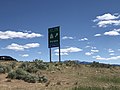
Southern end of SR64, as seen from southbound I-15. Signage on the northbound side of the freeway includes a reference to WEST US 50 (May 2020)
Approaching northern end of SR64. Eastbound US 50 arrives at a T-intersection at the edge of Holden and turns left, and the SR 64 is to the right (May 2020)
Signage at the T-intersection in Holden. This is the northern end of SR64, but the BGS simply points the way to Interstate 15 (May 2020)
History
Holden's Main Street became a state highway in 1910 as part of the main road south-southwesterly from Salt Lake City.[3] It was numbered as part of SR-1 and US-91 in the 1920s.[4] In 1969, with the construction of I-15 imminent, State Route 26 (now US-50), which had ended at SR-1 just north of Holden, was extended both north and south from its eastern end to meet I-15 on both sides of the bypass.[5] The state legislature redesignated the southern half as SR-64 in 1975,[6] about a year before I-15 was completed in the area.[7]
This page is based on this Wikipedia article Text is available under the CC BY-SA 4.0 license; additional terms may apply. Images, videos and audio are available under their respective licenses.