
The Erie Canal is a historic canal in upstate New York that runs east–west between the Hudson River and Lake Erie. Completed in 1825, the canal was the first navigable waterway connecting the Atlantic Ocean to the Great Lakes, vastly reducing the costs of transporting people and goods across the Appalachians. In effect, the canal accelerated the settlement of the Great Lakes region, the westward expansion of the United States, and the economic ascendancy of New York State. It has been called "The Nation's First Superhighway."

The St. Lawrence Seaway is a system of locks, canals, and channels in Canada and the United States that permits oceangoing vessels to travel from the Atlantic Ocean to the Great Lakes of North America, as far inland as Duluth, Minnesota, at the western end of Lake Superior. The seaway is named for the St. Lawrence River, which flows from Lake Ontario to the Atlantic Ocean. Legally, the seaway extends from Montreal, Quebec, to Lake Erie, and includes the Welland Canal. Ships from the Atlantic Ocean are able to reach ports in all five of the Great Lakes, via the Great Lakes Waterway.

The Illinois and Michigan Canal connected the Great Lakes to the Mississippi River and the Gulf of Mexico. In Illinois, it ran 96 miles (154 km) from the Chicago River in Bridgeport, Chicago to the Illinois River at LaSalle-Peru. The canal crossed the Chicago Portage, and helped establish Chicago as the transportation hub of the United States, before the railroad era. It was opened in 1848. Its function was partially replaced by the wider and deeper Chicago Sanitary and Ship Canal in 1900, and it ceased transportation operations with the completion of the Illinois Waterway in 1933.

The Illinois River is a principal tributary of the Mississippi River and is approximately 273 miles (439 km) long. Located in the U.S. state of Illinois, the river has a drainage basin of 28,756.6 square miles (74,479 km2). The Illinois River begins with the confluence of the Des Plaines and Kankakee rivers in the Chicago metropolitan area, and it generally flows to the southwest across Illinois, until it empties into the Mississippi near Grafton, Illinois. Its drainage basin extends into southeastern Wisconsin, northwestern Indiana, and a very small area of southwestern Michigan in addition to central Illinois. Along its shores are several river ports, including Peoria, Illinois. Historic and recreation areas on the river include Starved Rock, and the internationally important wetlands of the Emiquon Complex and Dixon Waterfowl Refuge.

Utica is a city in the Mohawk Valley and the county seat of Oneida County, New York, United States. The tenth-most-populous city in New York State, its population was 65,283 in the 2020 U.S. Census. Located on the Mohawk River at the foot of the Adirondack Mountains, it is approximately 95 mi (153 km) west-northwest of Albany, 55 mi (89 km) east of Syracuse and 240 mi (386 km) northwest of New York City. Utica and the nearby city of Rome anchor the Utica–Rome Metropolitan Statistical Area comprising all of Oneida and Herkimer Counties.

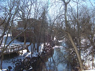
Marcy is a town in Oneida County, New York, United States. The population was 8,777 at the 2020 census. The town was named after Governor William L. Marcy. It lies between the cities of Rome and Utica. The Erie Canal passes through the southern part of the town.

The St. Marys River, sometimes written St. Mary's River, drains Lake Superior, starting at the end of Whitefish Bay and flowing 74.5 miles (119.9 km) southeast into Lake Huron, with a fall of 23 feet (7.0 m). For its entire length it is an international border, separating Michigan in the United States from Ontario, Canada.

New York Harbor is at the mouth of the Hudson River where it empties into New York Bay near the East River tidal estuary, and then into the Atlantic Ocean on the United States East coast.

The New York Central Railroad was a railroad primarily operating in the Great Lakes and Mid-Atlantic regions of the United States. The railroad primarily connected greater New York and Boston in the east with Chicago and St. Louis in the Midwest, along with the intermediate cities of Albany, Buffalo, Cleveland, Cincinnati, Detroit, Rochester and Syracuse. New York Central was headquartered in New York City's New York Central Building, adjacent to its largest station, Grand Central Terminal.

Panamax and New Panamax are terms for the size limits for ships travelling through the Panama Canal. The limits and requirements are published by the Panama Canal Authority (ACP) in a publication titled "Vessel Requirements". These requirements also describe topics like exceptional dry seasonal limits, propulsion, communications, and detailed ship design.
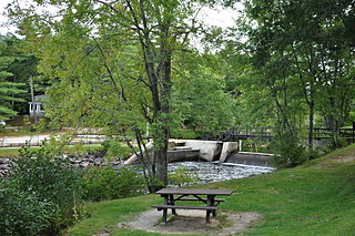
The Chenango Canal was a towpath canal in central New York in the United States which linked the Susquehanna River to the Erie Canal. Built and operated in the mid-19th century, it was 97 miles long and for much of its course followed the Chenango River, along New York State Route 12 from Binghamton on the south end to Utica on the north. It operated from 1834 to 1878 and provided a significant link in the water transportation system of the northeastern U.S. until supplanted by the region's developing railroad network.

The Port of Boston is a major seaport located in Boston Harbor and adjacent to the City of Boston. It is the largest port in Massachusetts and one of the principal ports on the East Coast of the United States.
The Canaveral Barge Canal is an active canal in Brevard County, Florida, cutting east-west across northern Merritt Island just south of Cape Canaveral. It connects the Atlantic Ocean and Port Canaveral with the Indian River and wider Indian River Lagoon, part of the Intracoastal Waterway. The canal consists of two segments separated by the Banana River.

The Industrial Canal is a 5.5 mile (9 km) waterway in New Orleans, Louisiana, United States. The waterway's proper name, as used by the U.S. Army Corps of Engineers and on NOAA nautical charts, is Inner Harbor Navigation Canal (IHNC). The more common "Industrial Canal" name is used locally, both by commercial mariners and by landside residents.

The Port of Antwerp is the port of the city of Antwerp, Belgium. It is located in Flanders, mainly in the province of Antwerp, but also partially in East Flanders. It is a seaport in the heart of Europe accessible to capesize ships. It is Europe's second-largest seaport, after that of Rotterdam. Antwerp stands at the upper end of the tidal estuary of the Scheldt. The estuary is navigable by ships of more than 100,000 Gross Tons as far as 80 km inland. Like the Port of Hamburg, the Port of Antwerp's inland location provides a more central location in Europe than the majority of North Sea ports. Antwerp's docks are connected to the hinterland by rail, road, and river and canal waterways. As a result, the port of Antwerp has become one of Europe's largest seaports, ranking second behind Rotterdam by total freight shipped. Its international rankings vary from 11th to 20th (AAPA). In 2012, the Port of Antwerp handled 14,220 sea trade ships, 57,044 inland barges, and offered liner services to 800 different maritime destinations.

The Port of New York and New Jersey is the port district of the New York-Newark metropolitan area, encompassing the region within approximately a 25-mile (40 km) radius of the Statue of Liberty National Monument.

The Dieze is a short river in North Brabant, the Netherlands, tributary of the Meuse. It is formed by the confluence of the rivers Aa and Dommel in 's-Hertogenbosch. The part of the Dieze in the centre of 's-Hertogenbosch is called Binnendieze, a partly covered network of canals. The Dieze flows into the Meuse near Hedel.
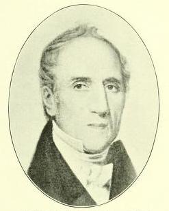
Nathan Williams was a United States representative from New York and the first lawyer to permanently establish a law practice in Utica. During the War of 1812 Williams volunteered for service and became a major in a company of militia at Sackett's Harbor.

The Susquehanna and Tidewater Canal between Wrightsville, Pennsylvania, and Havre de Grace, Maryland, at the head of Chesapeake Bay, provided an interstate shipping alternative to 19th-century arks, rafts, and boats plying the difficult waters of the lower Susquehanna River. Built between 1836 and 1840, it ran 43 miles (69 km) along the west bank of the river and rendered obsolete an older, shorter canal along the east bank. Of its total length, 30 miles (48 km) were in Pennsylvania and 13 miles (21 km) in Maryland. Although rivalry between Philadelphia, Pennsylvania, and Baltimore, Maryland, delayed its construction, the finished canal brought increased shipments of coal and other raw materials to both cities from Pennsylvania's interior. Competition from railroads was a large factor in the canal's decline after 1855. Canal remnants, including a lock keeper's house, have been preserved in Maryland, and locks 12 and 15 have been preserved in Pennsylvania.
Songo Lock is the last surviving lock of the Cumberland and Oxford Canal, a 19th-century canal in southern Maine, United States. The lock is located on the Songo River, just above its confluence with the Crooked River at the northern end of Sebago Lake State Park in the town of Naples. The lock, built in 1830, is now used primarily during the summer months by pleasure craft. It was listed on the National Register of Historic Places in 1970 and designated as a Maine Historic Civil Engineering Landmark by the American Society of Civil Engineers in 2001.


