
Nesna is a municipality in Nordland county, Norway. It is part of the Helgeland traditional region. The administrative centre of the municipality is the village of Nesna. Other villages in Nesna include Handnesneset, Husby, Saura, and Vikholmen.

Lurøy is a municipality in Nordland county, Norway. It is part of the Helgeland traditional region. The administrative centre of the municipality is the village of Lurøy, located on the island of Lurøya. Other villages in Lurøy include Aldra, Haugland, Konsvikosen, Lovund, Sleneset / Solværøyene, Stokkvågen, and Tonnes.
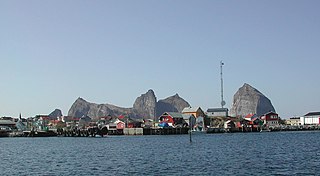
Træna is a municipality in Nordland county, Norway. It is part of the Helgeland traditional region. The administrative centre of the municipality is the island/village of Husøya. Other population centres include Selvær and Sanna.
Rødøy is a municipality in Nordland county, Norway. It is part of the Helgeland traditional region. The administrative centre of the municipality is the village of Vågaholmen. Other villages include Gjerøy, Jektvika, Kilboghamn, Melfjordbotn, Oldervika, Sørfjorden, and Tjong. The municipality consists of many islands to the west of Norway's second biggest glacier, Svartisen.

Fauske (Norwegian) or Fuossko (Lule Sami) is a municipality located in Nordland county, Norway. It is part of the traditional district of Salten. The administrative centre of the municipality is the town of Fauske. Some of the villages in Fauske include Nystad, Venset, Straumsnes, and Sulitjelma.
Mo i Rana is a town and the administrative centre of the municipality of Rana in Nordland county, Norway. It is located in the Helgeland region of Nordland, just south of the Arctic Circle. Some of the outlying areas of the town include the suburbs of Båsmoen and Ytteren in the north and Selfors in the east and Åga/Hauknes/Dalsgrenda in the south.

Mosjøen or Mussere (Southern Sami) is a town in Vefsn Municipality in Nordland county, Norway. Mosjøen is the oldest town in the Helgeland region, with only the town of Bodø being older within Nordland county. The town is also the administrative centre of Vefsn Municipality. The old village of Mosjøen was declared a ladested in 1875. It was also a town municipality from 1875 until 1961 when it was merged into Vefsn, losing its status as a town (ladested). It is also a former garrison town and customs place. In 1998, the urban area of Mosjøen was declared to be a town once again. People from Mosjøen are referred to using the demonym "mosjøværing". The 6.36-square-kilometre (1,570-acre) town has a population (2018) of 9,834 and a population density of 1,528 inhabitants per square kilometre (3,960/sq mi).
The Dunderland Valley is a valley in the municipality of Rana in Nordland county, Norway. It reaches from just below the eastern Saltfjellet plateau about 8 miles (13 km) south of the Arctic circle. The mountain Bolna is situated in the uppermost boundary of the valley which then proceeds to the southwest all the way down to the Ranfjorden. Some of the minor side valleys include Plurdalen, Røvassdalen, Bjøllådalen, Grønfjelldalen and Virvassdalen. The valley also includes several villages such as Krokstrand, Bjøllånes, Storvoll, Dunderland, Eiterå, Nevernes, Storforshei, Nevermoen and Røssvoll.

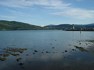
The Ranfjorden is a fjord in the Helgeland district of Nordland county, Norway. The largest part of the fjord is in the municipality of Rana, but the fjord also passes through the municipalities of Hemnes, Vefsn, Leirfjord, Nesna, and Dønna. The river Ranelva meets the Ranfjord in at the town of Mo i Rana at the innermost part of the fjord. It then flows to the west for about 68 kilometres (42 mi) to where it meets the sea along the border of Dønna and Nesna municipalities.

Langvatnet is a lake in the municipality of Rana in Nordland county, Norway. The 26.38-square-kilometre (10.19 sq mi) lake lies just northwest of the town of Mo i Rana. The lake flows out into the river Langvassåga just north of Mo i Rana Airport, Røssvoll. The lake used as a reservoir for the Langvatn hydroelectric power plant in the village of Ytteren, just down the hill from the lake.

Nord-Rana is a former municipality in Nordland county, Norway. The 3,980-square-kilometre (1,540 sq mi) municipality existed from 1839 until its dissolution in 1964. From 1839 until 1844, it was named Nord-Ranen, from 1844 until 1923, it was called Mo, and then from 1923 until 1964 it was named Nord-Rana. The former municipality was located at the innermost part of the Ranfjorden. It encompassed the eastern 90% of what is now Rana Municipality. The administrative centre was the village of Ytteren, just north of the town of Mo i Rana.
Flostrand is a village in the municipality of Rana in Nordland county, Norway. It is located along Norwegian County Road 17 on the northern bank of the Sjona fjord.
Myklebustad or Myklebostad is a village in the municipality of Rana in Nordland county, Norway. It is located along Norwegian County Road 17 on the southern bank of the Sjona fjord, just west of the villages of Mæla and Utskarpen. Sjona Church is located in the western part of Myklebustad, serving the western part of Rana municipality.
Mæla is a village in the municipality of Rana in Nordland county, Norway. It is located along Norwegian County Road 17 at the eastern end of the Sjona fjord, about 2 kilometres (1.2 mi) north of the villages of Utskarpen and Myklebustad.
Stokkvågen is a village and ferry port located in Lurøy Municipality in Nordland county, Norway. The village lies on the mainland coast of Lurøy, about 60 kilometres (37 mi) west of the town of Mo i Rana. The port has ferries that connect the mainland to the islands of Onøya, Lovund, Sleneset/Moflag, and Træna to the west and to the town of Sandnessjøen to the south. The village of Stokkvågen is located along Norwegian County Road 17, along the Sjona fjord.

Ytteren is a village in the municipality of Rana in Nordland county, Norway. Ytteren and the neighboring village of Båsmoen are northern suburbs of the town of Mo i Rana. They are both located on the northern edge of the mouth of the Ranelva river at the Ranfjorden. Norwegian County Road 12 runs through the village. The large lake Langvatnet lies about 2 kilometres (1.2 mi) north of the village.
Bardalssjøen or Bardal is a village in the municipality of Leirfjord in Nordland county, Norway. The village is located along the south coast of the Ranfjorden, about 10 kilometres (6.2 mi) west of the village of Hemnesberget. The village surrounds the Bardalselva river which flows into the fjord. The Bardal Church was built in 1887 on a hill near the mouth of the river. The Bardal area has historically been part of both Nesna Municipality and Hemnes Municipality, but it has been part of Leirfjord Municipality since 1964.


