Uxbridge Rural District

Last updated

Uxbridge Rural District
Uxbridge rural in mddx 1911.png
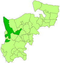
Uxbridge Rural District within the former administrative Middlesex (so excluding the county's south-eastern large contribution to the young County of London) as at 1911. It can be seen from the dark green subject zone that beyond to the north-east and to the south-east its former parishes: Ruislip (including Northwood its sub-breakaway); and Hayes broke away in 1904 and the new districts flanking the remaining eastern projection. The district excluded, since 1911, the thin band of Yiewsley Urban District towards the south. The small Uxbridge Urban District was from the outset separate likewise against the county boundary west.
History
  Created1875 (as a sanitary district)
  Abolished1929
  Succeeded by Uxbridge Urban District
Status Rural district
   HQ Uxbridge

Uxbridge Rural District was, from 1894 to 1929, a local government district in Middlesex, England.

Contents

Prior sanitary and poor law bodies

This entity amounted to a widening of the functions and powers of Uxbridge rural sanitary district formed in 1875. Alongside that district and the town's urban one, since the 1834 remodelling of the poor law and until 1894, the Uxbridge Poor Law Union existed.

The district, and union, excluded the three small southern and three small eastern parishes of Elthorne Hundred an early medieval unit of varied but always relatively little importance after the English reformation.

A little of Hillingdon, the parish bounding Uxbridge on three of its four sides, moved from the sanitary district to the urban district in 1883.

The parish of Northwood was removed in 1891, forming an urban sanitary district.

As across England, the more local, overlapping, civil parish councils began at a similar time as the sanitary districts, ending the vestries system which in many matters empowered the local Church of England laity.

Incorporation by statute

Under the Local Government Act 1894 the rural sanitary and poor law bodies mentioned became a rural district, thus a led by a council directly elected by a wide electorate of local residents.

Hillingdon civil parish was, like most, formed during the 1870s and when districts began it was not dissolved but rather remained as a weakened body. It was weakened like the others and split in two to work alongside the 1894 changes: Hillingdon West also by this time commonly seen as part of Uxbridge reflecting its housing and church-building expansion joined the compact Uxbridge urban district; Hillingdon East fell into the rural district.

As of 1894, the district comprised parishes:

Note: A daughter civil parish, Yiewsley, named after a similarly sized historic manor was created in 1896, the former southern band of Hillingdon.

Hayes became an urban district in 1904, as did Ruislip (re-merged of sorts with its daughter parish under the name Ruislip-Northwood). A Yiewsley Urban District was created in 1911, creating the only interruption in geographical continuity in the district. Northolt, an eastern 'winged' triangle of mainly Interwar housing was split in 1928 between the Municipal Borough of Ealing and Harrow on the Hill Urban District.

The district was abolished in 1929. It became part of the Uxbridge Urban District, apart from the outlying, compact southern parish of West Drayton which became part of the clear-components Yiewsley and West Drayton Urban District.

Modern resonances

Local government

The sanitary district plus Uxbridge (thus the Poor Law Union) plus three of the six other parishes of long-obsolete Elthorne Hundred, are bar one parish, identical to the London Borough of Hillingdon. The exception is Northolt split between the London Boroughs of Ealing and Brent. The largely sidestepped civil parish councils were abolished, locally, in the mid 20th century and only very few have been formed afresh across Greater London.

Postcodes

Apart from what was for centuries all Ruislip, including Northwood and Eastcote in the HA postcode area, but with eastern additions as far as the old Elthorne Hundred, the poor law union emulates the UB postcode area.

Related Research Articles

Cowley, London Suburban village in the United Kingdom

Cowley is a village contiguous with the town of Uxbridge in the London Borough of Hillingdon. A largely suburban village with 16 listed buildings, Cowley is 15.4 miles (24.8 km) west of Charing Cross, bordered to the west by Uxbridge Moor in the Green Belt and the River Colne, forming the border with Buckinghamshire. Cowley was an ancient parish in the historic county of Middlesex.

Northwood, London Human settlement in England

Northwood is an area in northwest London, England. It is located within the London Borough of Hillingdon on the border with Hertfordshire and 14.5 miles (23.3 km) from Charing Cross. Northwood was part of the ancient parish of Ruislip, Middlesex and has formed part of Greater London since 1965.

Ruislip Human settlement in England

Ruislip is an area in the London Borough of Hillingdon. Ruislip lies 13.8 miles (22.2 km) west-north-west of Charing Cross, London.

Uxbridge Town in the west of Greater London, England

Uxbridge is a suburban town in West London and the administrative headquarters of the London Borough of Hillingdon. Situated 15.4 miles (24.8 km) west-northwest of Charing Cross, it is one of the major metropolitan centres identified in the London Plan. Uxbridge formed part of the parish of Hillingdon in the county of Middlesex, and was a significant local commercial centre from an early time. As part of the suburban growth of London in the 20th century it expanded and increased in population, becoming a municipal borough in 1955, and has formed part of Greater London since 1965.

Yiewsley Suburban village in the United Kingdom

Yiewsley is a large suburban village in the London Borough of Hillingdon, England, 2 miles (3 km) south of Uxbridge, the borough's commercial and administrative centre. Yiewsley was a chapelry in the ancient parish of Hillingdon, Middlesex. The population of the ward was 12,979 at the 2011 Census.

London Borough of Hillingdon London borough in United Kingdom

The London Borough of Hillingdon is a large borough in West London, England. It was formed from the districts of Hayes and Harlington, Ruislip-Northwood, Uxbridge, and Yiewsley and West Drayton in the ceremonial county of Middlesex. Today, Hillingdon is home to Heathrow Airport and Brunel University, and is the second largest of the 32 London boroughs by area.

Eastcote Human settlement in England

Eastcote is an area in the London Borough of Hillingdon. It is in northwest London and the historic county of Middlesex.

Hillingdon Suburban area within the London Borough of Hillingdon

Hillingdon is an area of Uxbridge within the London Borough of Hillingdon, centred 14.2 miles (22.8 km) west of Charing Cross. It was an ancient parish in Middlesex that included the market town of Uxbridge. During the 1920s the civil parish bore a rapid, planned increase in population and housing, and was absorbed by Uxbridge Urban District in 1929. It has formed part of Greater London since 1965.

Uxbridge (UK Parliament constituency) Parliamentary constituency in the United Kingdom, 1885–2010

Uxbridge was a seat returning one Member of Parliament (MP) of the House of Commons of the UK Parliament from 1885 to 2010. Its MPs elected were: Conservative Party candidates for 107 years and Labour Party candidates for 18 years. The closing 40 years of the seat's history saw Conservative victory — in 1997 on a very marginal majority in relative terms.

Municipal Borough of Uxbridge

Uxbridge was a local government district in north west Middlesex, England, from 1849 to 1965, seated in the town of Uxbridge.

Elthorne Hundred

Elthorne was a hundred of the historic county of Middlesex, England.

London Government Act 1963 United Kingdom legislation

The London Government Act 1963 is an Act of the Parliament of the United Kingdom, which created Greater London and a new local government structure within it. The Act significantly reduced the number of local government districts in the area, resulting in local authorities responsible for larger areas and populations. The upper tier of local government was reformed to cover the whole of the Greater London area and with a more strategic role; and the split of functions between upper and lower tiers was recast. The Act classified the boroughs into inner and outer London groups. The City of London and its corporation were essentially unreformed by the legislation. Subsequent amendments to the Act have significantly amended the upper tier arrangements, with the Greater London Council abolished in 1986, and the Greater London Authority introduced in 2000. As of 2016, the London boroughs are more or less identical to those created in 1965, although with some enhanced powers over services such as waste management and education.

Yiewsley and West Drayton Urban District


Yiewsley and West Drayton was a local government district in Middlesex, England from 1929 to 1965. Its area became the south-west of the London Borough of Hillingdon.

Uxbridge and South Ruislip (UK Parliament constituency) Parliamentary constituency in the United Kingdom, 2010 onwards

Uxbridge and South Ruislip is a constituency of the UK Parliament in Greater London created in 2010. The seat has been held by the Conservative Party since its creation, and since 2015 has been represented by Boris Johnson, who has served as Prime Minister of the United Kingdom since 2019.

Ruislip Manor Human settlement in England

Ruislip Manor is an area of Ruislip in the London Borough of Hillingdon. It is located approximately 13 miles (20.9 km) north west of Charing Cross.

Hillingdon London Borough Council

Hillingdon London Borough Council is the local authority for the London Borough of Hillingdon in Greater London, England. It is a London borough council, one of 32 in the United Kingdom capital of London. Hillingdon is divided into 22 wards, electing a total of 65 councillors. The council was created by the London Government Act 1963 and replaced four local authorities: Uxbridge Borough Council, Hayes and Harlington Urban District Council, Ruislip-Northwood Urban District Council and Yiewsley and West Drayton Urban District Council.

The 1964 Hillingdon Council election took place on 7 May 1964 to elect members of Hillingdon London Borough Council in London, England. The whole council was up for election and the Labour party gained control of the council.

Coat of arms of the London Borough of Hillingdon

The coat of arms of the London Borough of Hillingdon is the official symbol of the London Borough of Hillingdon. They use elements from the coats of arms of the four previous districts. It is described as:

Arms: Per pale Gules and Vert an Eagle displayed per pale Or and Argent in the dexter claw a Fleur-de-lis Or and in the sinister claw a Cog-Wheel Argent on a Chief Or four Civic Crowns Vert.

Crest: On a Wreath of the Colours issuant from a Circlet of Brushwood Sable a demi-Lion Gules with wings Argent the underside of each wing charged with a Cross Gules and holding between the paws a Bezant thereon a Mullet Azure.

Supporters: On the dexter side an Heraldic Tiger Or gorged with an Astral Crown Azure and charged on the shoulder with a Rose Gules charged with another Argent barbed and seeded proper and on the sinister side a Stag proper attired and gorged with a Circlet of Brushwood and charged on the shoulder with two Ears of Rye slipped in saltire Or.

Motto: Forward.

References

Coordinates: 51°34′N0°28′W / 51.57°N 0.47°W / 51.57; -0.47 (Uxbridge RD)