This article has multiple issues. Please help improve it or discuss these issues on the talk page . (Learn how and when to remove these template messages)
|
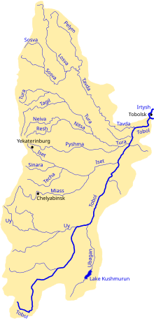
The Uy River (Russian : Уй, Bashkir : Уй) is a river in Chelyabinsk Oblast in Russia with its upper reaches in Bashkiria. It partially flows along the borders of Chelyabinsk and Kurgan Oblasts with Kazakhstan. The Uy is a left tributary of the Tobol River. The length of the river is 462 km. The area of its basin is 34,400 km². It freezes up in November and stays icebound in April. The town of Troitsk and three reservoirs (the largest being Troitsk Reservoir) are situated on the Uy River.
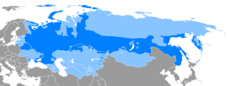
Russian is an East Slavic language, which is official in the Russian Federation, Belarus, Kazakhstan and Kyrgyzstan, as well as being widely used throughout Eastern Europe, the Baltic states, the Caucasus and Central Asia. It was the de facto language of the Soviet Union until its dissolution on 25 December 1991. Although, nowadays, nearly three decades after the breakup of the Soviet Union, Russian is used in official capacity or in public life in all the post-Soviet nation-states, as well as in Israel and Mongolia, the rise of state-specific varieties of this language tends to be strongly denied in Russia, in line with the Russian World ideology.
The Bashkir language is a Turkic language belonging to the Kipchak branch. It is co-official with Russian in the Republic of Bashkortostan, European Russia and has approximately 1.2 million speakers in Russia. Bashkir has three dialects: Southern, Eastern and Northwestern.
A river is a natural flowing watercourse, usually freshwater, flowing towards an ocean, sea, lake or another river. In some cases a river flows into the ground and becomes dry at the end of its course without reaching another body of water. Small rivers can be referred to using names such as stream, creek, brook, rivulet, and rill. There are no official definitions for the generic term river as applied to geographic features, although in some countries or communities a stream is defined by its size. Many names for small rivers are specific to geographic location; examples are "run" in some parts of the United States, "burn" in Scotland and northeast England, and "beck" in northern England. Sometimes a river is defined as being larger than a creek, but not always: the language is vague.
It rises in the southern Ural Mountains east of the headwaters of the Ural River between Chelyabinsk and Magnitogorsk and flows east with many meanders past Troitsk, Chelyabinsk Oblast to meet the Tobol River near Zverinogolovskoye (formerly the fort of Ust-Uysk). The gold-mining town of Plast (town) is on its headwaters. At the time of the Bashkir War of 1735-40 it was the eastern end of the Orenburg Line of forts and is now approximately part of the border between Russia and Kazakhstan. The Uy is the southernmost river on the east side of the Urals whose waters ultimately reach the Arctic Ocean. South of the Uy waters run to the Ural River which flows south into the Caspian Sea.
The Ural Mountains, or simply the Urals, are a mountain range that runs approximately from north to south through western Russia, from the coast of the Arctic Ocean to the Ural River and northwestern Kazakhstan. The mountain range forms part of the conventional boundary between the continents of Europe and Asia. Vaygach Island and the islands of Novaya Zemlya form a further continuation of the chain to the north into the Arctic Ocean.
The Ural, known as Yaik before 1775, is a river flowing through Russia and Kazakhstan in Eurasia. It originates in the southern Ural Mountains and discharges into the Caspian Sea. At 2,428 kilometres (1,509 mi), it is the third-longest river in Europe after the Volga and the Danube, and the 18th-longest river in Asia. The Ural River is conventionally considered part of the boundary between the continents of Europe and Asia.
Chelyabinsk is a city and the administrative center of Chelyabinsk Oblast, Russia, located in the northeast of the oblast, 210 kilometers (130 mi) south of Yekaterinburg, just to the east of the Ural Mountains, on the Miass River, on the border of Europe and Asia. Population: 1,130,132 (2010 Census); 1,077,174 (2002 Census); 1,141,777 (1989 Census).
The name of the river comes from the Bashkir language, in which it means "valley, lowland".
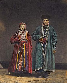
The Bashkirs are a Turkic ethnic group, indigenous to Bashkortostan and to the historical region of Badzhgard, extending on both sides of the Ural Mountains, in the area where Eastern Europe meets North Asia. Smaller communities of Bashkirs also live in the Republic of Tatarstan, Perm Krai, Chelyabinsk, Orenburg, Tyumen, Sverdlovsk, Kurgan Oblasts and other regions of Russia, as well as in Kazakhstan and other countries.
Chelyabinsk Oblast is a federal subject of Russia in the Ural Mountains region, on the border of Europe and Asia. Its administrative center is the city of Chelyabinsk. Population: 3,476,217.
The Tura River, also known as Dolgaya River is a historically important Siberian river which flows eastward from the central Ural Mountains into the Tobol River, a part of the Ob River basin. The main town on it is Tyumen.
Iremel is a compact mountain ridge in the Southern Ural Mountains in the republic of Bashkortostan, Russian Federation. The highest peak, Bolshoy Iremel, or simply Iremel, stands at 1589 metres (5200 ft) high. Maly Iremel, 6 kilometers north-east, stands at 1449 meters. It is the source of the River Belaya.
Ural Economic Region is one of twelve economic regions of Russia. This prominent industrial region consists of the following subdivisions : Bashkortostan (Ufa), Chelyabinsk Oblast (Chelyabinsk), Kurgan Oblast (Kurgan), Orenburg Oblast (Orenburg), Perm Krai (Perm), Sverdlovsk Oblast (Yekaterinburg) and Udmurt Republic (Izhevsk). It is mostly located in the Central, and partly in the Southern and Northern parts of the Urals, but also includes parts of the East European and West Siberian Plains. Its extent is different from that of the Ural Federal District; Bashkortostan, Orenburg Oblast. Perm Krai and Udmurtia are in the Volga Federal District while the other three are in the Ural Federal District.
Troitsk is a town in Chelyabinsk Oblast, Russia, located 175 kilometers (109 mi) east of the southern Ural Mountains and approximately 110 kilometers (68 mi) south of Chelyabinsk on the border with Kazakhstan. It stands on the east-flowing Uy River, a branch of the Tobol River. Population: 78,372 (2010 Census); 83,862 ; 90,077 (1989 Census).
Miass River is a river on the eastern side of the Ural Mountains. It flows through Bashkortostan, Chelyabinsk Oblast, and Kurgan Oblast.
Ural is a geographical region located around the Ural Mountains, between the East European and West Siberian plains. It is considered a part of Eurasian Steppe, extending approximately from the North to the South; from the Arctic Ocean to the end of Ural River near Orsk city. The border between Europe and Asia runs along the Eastern side of the Ural Mountains. Ural mostly lies within Russia but also includes a small part of Northwestern Kazakhstan. This is a historical, not an official entity, with borders overlapping its Western Volga and Eastern Siberia neighboring regions. At some point in the past, parts of the currently existing Ural region were considered a gateway to Siberia, or even Siberia itself, and were combined with the Volga administrative divisions. Today, there are two official namesake entities; the Ural Federal District and the Ural economic region. While the latter follows the historical borders, the former is a political product; the District omits Western Ural and includes Western Siberia instead.
The Turgai River is a river that flows in the Turgai Valley in Kazakhstan.
The Tavda River is a Siberian river that drains part of the central Ural mountains into the Tobol River. It is north of the Tura River and south of the Konda River. It is located in Sverdlovsk Oblast and Tyumen Oblast.
Lake Chebarkul is a lake in Chebarkulsky District, Chelyabinsk Oblast, Russia, on the slopes of the southern Urals. The town of Chebarkul lies on its eastern shore, and Chelyabinsk, the administrative center of Chelyabinsk Oblast, is located about 70 kilometres (43 mi) to the northeast. The name of the lake, and the city of the same name, comes from Turkic and means "Beautiful, colorful lake."
Kostanay Region is a region of Kazakhstan. Its administrative center is the city of Kostanay. The population of the region is 900,300. The population living in Kostanay is 207,000 which is equivalent to 23% of the region.
Sim River is a river in Chelyabinsk Oblast and the Republic of Bashkortostan in Russia. It is a tributary of the Belaya River, part of the Volga watershed. Its length is 239 kilometers (149 mi).
Argazi Reservoir is a reservoir, created on the Miass River in Chelyabinsk Oblast (Russia) in 1946. The Argazi Lake has become a part of the Argazi Reservoir ever since. The reservoir has a surface area of 102 km² and a water volume of 0,65 cubic km. Its length is 11 km, average depth - 6,5 m. The Argazi Reservoir was created for the benefit of energetics and water supply. It also performs perennial flow regulation.
Perm Governorate was an administrative unit of the Russian Empire and the Soviet Union from 1781 to 1923. It was located on both slopes of the Ural Mountains, and its administrative center was the city of Perm. The region gave its name to the Permian period.
Bashkiriya National Park, covers a large contiguous forest on the southern end of the Ural Mountains. The park is an important buffer between the industrialized flatlands to the west, and the mountainous and sparsely-populated Shulgan-Tash nature reserve and Altyn-Solok entomological reserve to the east and north. Bashkirya National Park lies between the Nugush River, and the southern bend of the Belaya River. The park features deep river valley cuts in a karst topography. It is known for a natural bridge across the river Kuperlya. The park is situated across three districts of the Republic of Bashkortostan.
Ayat is a river in Chelyabinsk Oblast, Russia and Kostanay Region, Kazakhstan. Ayat is formed by the confluence of Karataly-Ayat and Archagly-Ayat. The river flows into the river Tobol district in Karatomar reservoir. The length of the river is 117 km, with a catchment area of 13 300 km².
The Bashkir rebellion of 1735–1740 refers to a rebellion which was initiated by the Bashkirs against the Russian Empire. The rebellion was initiated in 1735, but was put down by Russian and pro-Russian Bashkir troops in 1740 after a series of heavy clashes.
The Great Soviet Encyclopedia is one of the largest Russian-language encyclopedias, published by the Soviet state from 1926 to 1990, and again since 2002 by Russia. The GSE claimed to be "the first Marxist-Leninist general-purpose encyclopedia".
The public domain consists of all the creative works to which no exclusive intellectual property rights apply. Those rights may have expired, been forfeited, expressly waived, or may be inapplicable.
Coordinates: 54°17′54″N63°58′45″E / 54.2983°N 63.9792°E

A geographic coordinate system is a coordinate system that enables every location on Earth to be specified by a set of numbers, letters or symbols. The coordinates are often chosen such that one of the numbers represents a vertical position and two or three of the numbers represent a horizontal position; alternatively, a geographic position may be expressed in a combined three-dimensional Cartesian vector. A common choice of coordinates is latitude, longitude and elevation. To specify a location on a plane requires a map projection.
| This Chelyabinsk Oblast location article is a stub. You can help Wikipedia by expanding it. |
| This Bashkortostan location article is a stub. You can help Wikipedia by expanding it. |
| This Kurgan Oblast location article is a stub. You can help Wikipedia by expanding it. |
| This article related to a river in Russia is a stub. You can help Wikipedia by expanding it. |
| This article related to a river in Kazakhstan is a stub. You can help Wikipedia by expanding it. |