
Mannargudi is a town in Thiruvarur district in the Indian state of Tamil Nadu. It is the headquarters of the Mannargudi taluk. The town is located at a distance of 28 km (17 mi) from the district headquarters Thiruvarur, 36 km from Kumbakonam, 40 km from Thanjavur and 310 km (190 mi) from the state capital Chennai. Mannargudi is known for the Rajagopalaswamy temple, a prominent Vaishnavite shrine.
Madukkur is a Town Panchayat in Thanjavur District, Tamil Nadu, India. The town is located at middle east part of Tamil Nadu. It has 34 Union panchayat villages in rural. Being the Cauvery River Delta inhabitants.
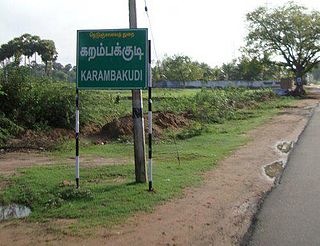
Karambakkudi is a panchayat town as well as Taluk in Pudukkottai district in the Indian state of Tamil Nadu. Karambakkudi is located about 40 km from Thanjavur and 40 km from Pudukkottai. This town is located on the border of the Thanjavur and Pudukkottai district in Tamil Nadu. The opinion of the people of this area is that this area should become an assembly constituency very soon, Here all higher secondary schools and Art's college is there.This area is covered by Delta Region.

Needamangalam (Nidamangalam) formerly Yamunambalpuram, is a town panchayat in Thiruvarur district in the Cauvery Delta of Indian state of Tamil Nadu. Needamangalam was originally part of the composite Tanjore Dist during British Raj until 1997 AD. In the 18th and 19th century, it was also called Yamunambalpuram. Needamangalam is the headquarters of the Needamangalam Taluk. The town is located 20 km east of Thanjavur, 80 km east of Tiruchirappalli and 318 km south of Chennai. Needamangalam is a junction for two busy highways, (i) National Highway 67 is a National Highway in Southern Indian states of Tamil Nadu and Karnataka that runs from Nagapattinam, a sea-side town in Tamil Nadu to Gundlupet, Karnataka (ii) State Highway SH-66 connecting Kumbakonam with Adirampattinam via Mannargudi in Cauvery Delta.

Pattukkottai is a major town in Thanjavur district in the Indian state of Tamil Nadu and also important town in Delta districts and Commercial town of Thanjavur, Thiruvarur and Pudukkottai district Coastal areas. The town came to prominence throughout Southern India after the construction of the fort by Vanaji Pandithar, a feudatory of the Thanjavur Maratha ruler Shahuji I in 1686–87. The recorded history of Pattukkottai is known from the 17th century and has been ruled, at different times, by the Thanjavur Marathas and the British. It is the headquarters of the Pattukkottai taluk of Thanjavur district and is one of the two municipalities in the district.
Soorappallam is a village located 1 km away from Pattukkottai town in Thanjavur district in Tamil Nadu state in India on the way to Mannargudi and Kumbakonam via Vadaseri.
Orathanad is a town in Thanjavur district of the Indian state of Tamil Nadu. It is recognised as a Town Panchayat. It is located at a distance of 33 km from Thanjavur and 23 km from Mannargudi. The town is surrounded by vast agricultural lands.

Thanjavur district is one of the 38 districts of the state of Tamil Nadu, in southeastern India. Its headquarters is Thanjavur (Tanjore). The district is located in the delta of the Cauvery River and is mostly agrarian.
Alathur is a village in Pattukkottai taluk of Thanjavur district, Tamil Nadu, India. Alathur village is a division of Musugundha Nadu part of Chola Nadu.It is located approximately eight kilometers from Pattukkottai - Mannargudi with the well-connected road of State Highway a route called Sethubachathiram Road. It is the third biggest village in pattukkottai taluk after Thamarankottai and Thambikottai. Alathur is an Agricultural community, Commercial market and Centres.
Thennamanadu is a village panchayat in Orattanadu Block of Thanjavur district in Tamil Nadu, South India. It is located between the cities of Thanjavur and Pattukkottai, 20 km (12 mi) from Thanjavur, 2 km (1.2 mi) from Orathanadu and 339 km (211 mi) from the state capital Chennai.

Thirumakkottai is a village in Mannargudi municipality in Thiruvarur district in the Indian state of Tamil Nadu. The village is Thirumakkottai consist of many streets like North street, South street, Bazaar Street, New street,Sivan koil street, Ponniyamman Temple Street, Theradi street, Nallan Pillai street.
Neivelivadapathy is a village in the Orathanadu taluk of Thanjavur district, Tamil Nadu, India.

Peikkarumbankottai is a village in the Orathanadu taluk of Thanjavur district, Tamil Nadu, India.
Pinnaiyur is a village in Thanjavur district of the Indian state of Tamil Nadu. It is located in Orathanadu taluk.
Thelungan Kudikadu is a village in the Orathanadu taluk of Thanjavur district, Tamil Nadu, India.
Vellur is a village in the Orathanadu taluk of Thanjavur district in the Indian state of Tamil Nadu. Vellur, also known as Vellur Nadu, is an agricultural village.
Mannankadu is a village in the Pattukkottai taluk of Thanjavur district, Tamil Nadu, India. It is one of the 32 villages falls under the Musugundan Nadu in the district. Mannangadu is one of the revenue village in its taluk. It is located on state highway Adirampattinam-Mannargudi-Kumbakonam, between Adirampattinam and Madukkur. It is the fourth largest village in Pattukkottai taluk, after Thamarankottai, Thambikottai and Aalathur. Total geographical area of the Village is 1002.02 hectares. The main income source of this village is Agriculture.
Nemmeli is an agricultural village in Madukkur Panchayat Union, Pattukkottai taluk of Thanjavur district, Tamil Nadu, India, also known as 28.Nemmeli. Nemmeli village is division of Musugundha Nadu in Chola nadu. It comes under Pattukottai legislative constituency and Tanjore Parliament constituency. It is a small and well developing village located in the southern part of Tamil Nadu. It is 15 km from Pattukkottai and Mannargudi. It is surrounded with number of villages. Being in the Cauvery River Delta Area the inhabitants’ main occupation is agriculture. The younger generation is well educated, and they are working in various locations in India. They are also working in foreign countries like Singapore, Malaysia, UAE, Saudi Arabia, UK, and USA. The economy is booming in line with India’s rapid economic development. Nemmeli Seawater Desalination Plant located in the township is a major drinking water supply source for South Chennai since 2010.
Vadiyakkadu is a village in the Madukkur Panchayat Union, Pattukkottai taluk of Thanjavur district, Tamil Nadu, India, also known as Vadiyakkadu. It is a small and well developing Village located in southern part of Tamil Nadu. It is 15 km from Pattukkottai. It is surrounded with number of villages. Being in the Cauvery River Delta Area the inhabitants’ main occupation is agriculture. Tamil is the official language and is predominantly spoken.

Kalathur is a panchayat village in Peravurani panchayat Union of Thanjavur district in the Indian state of Tamil Nadu. Kalathur is a part of the Pattukkottai taluk of Thanjavur district and located 67 kilometres (42 mi) south of Thanjavur connected via State Highway 29.