
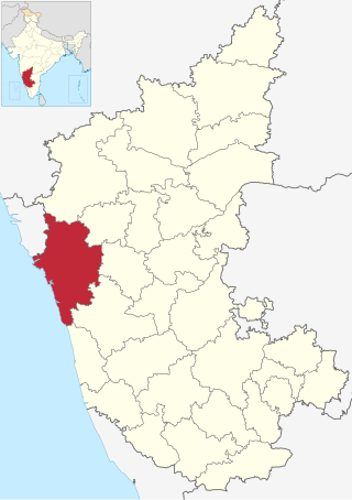
Uttara Kannada is a district in the Indian state of Karnataka. Uttara Kannada District is a major coastal district of Karnataka, with the largest coastal district. It is bordered by the state of Goa and Belagavi District to the north, Dharwad District and Haveri District to the east, Shivamogga District, and Udupi District to the south, and the Arabian Sea to the west.
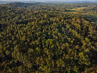
Malnad is a region in the state of Karnataka in India. Malenadu covers the western and eastern slopes of the Western Ghats or Sahyadri mountain range, and is roughly 100 kilometers in width.
Torke is a small village in Kumta taluk of Uttara Kannada district, Karnataka, India. This village is about a few square kilometres in extent. Torke traditionally is the amalgamation of Hoskatt, Naranapur, Toregazani, Torke, Devarabhavi, Hallergudi, Devana and Gonehalli. It has a Gram Panchayat.
Ankola is a Town Municipal Council and a taluka in Uttara Kannada district of the Indian state of Karnataka. The name of the place is derived from a forest shrub Ankola grown on the coastal hill side and worshiped by the Halakki Vokkaligas as a totem. The town is around 33 km (21 mi) from Karwar and 86 km (53 mi) from Sirsi.

Kumta is a town and taluk in the Uttara Kannada district of Karnataka, India. It is one of the important stations along the Konkan Railway line running between Mumbai and Mangalore.

Sirsi is a city in Uttara Kannada district of Karnataka state in India. It was also known as Kalyana Pattana during the Sonda Dynasty. It is a tourist destination with evergreen forest and waterfalls and is also a commercial centre. The main businesses around the city are mostly subsistence and agriculture-based. Areca nut or betel nut, locally known as Adike, is the primary crop grown in the nearby villages, making it one of the major trading centres for areca nut. The region is also known for spices such as cardamom, pepper, betel leaves, and vanilla. The major food crop is paddy.

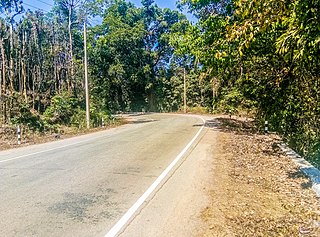
Ghat Roads are access routes into the mountainous Western and Eastern Ghats, mountain ranges of the Indian subcontinent. These roads are remarkable feats of engineering, and most were constructed during the British Raj. Ghat roads were built to connect to the hill stations established in the mountains for residents to avoid summer heat. They generally served to connect coastal (seaside) areas with the upper Deccan plateau of the Indian subcontinent.
Yellapura is a town in the Uttara Kannada district of Karnataka, India.It is a major trading centre for Arecanut, which is the primary crop grown in the villages surrounding the town. Approximately 90% of the population of Yellapura are farmers who grow Arecanut and paddy.

Tadadi (Tadari) is one of the ports in Uttara Kannada, Karnataka, India. It is near Gokarna in Kumta taluk.
Achanalli is a village in the southern state of Karnataka, India. It is located in the Sirsi taluk of Uttara Kannada district in Karnataka.
Achave is a village in the southern state of Karnataka, India. It is located in the Ankola taluk of Uttara Kannada district in Karnataka.
Adnalli is a village in the southern state of Karnataka, India. It is located in the Sirsi taluk of Uttara Kannada district in Karnataka.
Aigalkurve is a village in the southern state of Karnataka, India. It is located in the Kumta taluk of Uttara Kannada district in Karnataka.
Ajjibal is a village in the southern state of Karnataka, India. It is located in the Sirsi taluk of Uttara Kannada district in Karnataka.

Yana is a tourist destination located in forests of Malenadu region of Uttara Kannada district of Karnataka state in India. Yana is one of the wettest villages in the world. It is the cleanest village in Karnataka, and the second cleanest village in India. The two unique rock outcrops near the village are a tourist attraction and easily approachable by a small trek through 0.5 kilometres (0.31 mi) of thick forests from the nearest road head.

The following outline is provided as an overview of and topical guide to Karnataka:

Devimane is a Hill station and High altitude village in Sirsi taluk of Malenadu region in Karnataka, The road to reach this Hill Station is named as Devimane Ghat lies in NH 766E ultimately connecting Malenadu city Sirsi and Karavali town Kumta. Being under the lush forest zone in Uttara Kannada District it consists of 10 hairpin curves currently with a well-engineered road that reduces the risk of accidents. The road's elevation ranges from 25 to 567 metres. A temple of Goddess Durga Devi is at the beginning of this road at elevation 429m, The ghat section was named after the temple "Devimane", meaning "the home of goddess Devi". There are 5 hairpins curves between Devimane Temple and Sampakhanda. So, Totally there are 15 Hairpin Turns in this stretch of road.
Sampkhanda or Samphakanda is a Hill station of Western Ghats located in Sirsi Taluk of Uttara Kannada District, Karnataka, India. State Highway 69 passes through this village. It is 18 km (11 mi) away from Devimane Ghat and about 16 km (9.9 mi) from its Taluk Headquarters at Sirsi. Sampakhanda is considered one of the coldest places in Karnataka during summer season.

Vibhuthi Falls is located in Achave Gram panchayat,Ankola taluk of Uttara Kannada district in Karnataka, India. The word "Vibhuthi" means limestone. The water in this falls comes past limestone rocks near Yana and so the falls is called as "Vibhuthi Falls". Nearest towns near Vibhuthi falls are Sirsi, Kumta, Ankola, Gokarna.
Shivaganga Falls is a water fall and a tourist destination located at a distance of 37 km (23 mi) from Sirsi in Karnataka state of India.
