Related Research Articles
Radhanpur is a city and a municipality in Patan district in the Indian state of Gujarat.
Kankrej thana or Kankrej Estates was a former collection of native states in what is now part of Banaskantha district of Gujarat, India.

Vav is a town and the headquarters of Vav Taluka in banaskantha district in Gujarat state of India. Vav is the largest taluka of the district.

Vira is a village in Anjar Taluka in Kutch district of Gujarat, India. Nearby temple of Jogninar is place of religious significance.
Ramas is a town and former Makwana Koli princely state in Mahi Kantha.

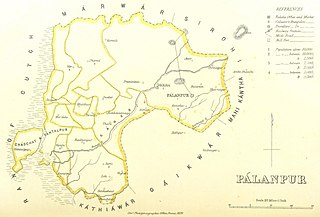
Radhanpur is a town and a municipality in Patan district in the Indian state of Gujarat. Radhanpur belonged to the Vaghelas in early years and later it was held as a fief under the Gujarat Sultanate by Fateh Khan Baloch. During Mughal period, the descendants of Babi dynasty were appointed as the governor of Radhanpur and other villages of North Gujarat. After decline of Mughal, they became free and established themselves as independent rulers. In 1743, Babi descendant Jawan Mard Khan II took over viceroyalty of Ahmedabad and controlled several villages in North Gujarat. He was defeated by Maratha Gaekwads in 1753 at Ahmedabad and Gaekwads agreed to his demand of control of villages in North Gujarat headquartered at Radhanpur State. His descendants lost some of these villages to Gaekwads subsequently. In 1813, Sher Khan made a treaty with the Gaekwar and British and became British protectorate. His descendants ruled the state until independence of India in 1947.
Santalpur is a village in Santalpur Taluka of Patan district of Gujarat state, India.
Varahi is a village in Santalpur taluka of Patan district of Gujarat state of India.
Diyodar, also spelled Diodar or Deodar, is a town and former princely state in Diyodar Taluka of Banaskantha district in Gujarat, western India.
Suigam was a village in Vav Taluka of Maratha Riyasat in Gujarat, India, but it is now a Taluka of Banaskantha district in Gujarat.
Tervada is a village in Kankrej Taluka of Banaskantha district in Gujarat, India.
Morvada is a village in Vav Taluka of Banaskantha district in Gujarat, India.
Bhabhar is a town in the Banaskantha district of Gujarat, India.
Dhima is a village in Vav Taluka of Banaskantha district in Gujarat, India.
Kakar is a village in Kankrej Taluka of Banaskantha district in Gujarat, India.
Kasara is a village in Kankrej Taluka of Banaskantha district in Gujarat, India.
Panchasar is a village in Shankheshwar Taluka of Patan district of Gujarat, India.
Sami is a town in Sami Taluka of Patan district of Gujarat, India.
Vadhiyar, also spelled Vadhiar, is a region of sami, shankheshwar and Harij Taluka of Patan district of Gujarat, India.
Chadchat is a region surrounding Santalpur in Patan district of Gujarat, India.
References
Notes
Bibliography
Chisholm, Hugh, ed. (1911). . Encyclopædia Britannica (11th ed.). Cambridge University Press.
- Gazetteer of the Bombay Presidency: Cutch, Palanpur, and Mahi Kantha. Government Central Press. 1880. p. 350.
![]() This article incorporates text from a publication now in the public domain: Gazetteer of the Bombay Presidency: Cutch, Palanpur, and Mahi Kantha. Government Central Press. 1880. p. 350.
This article incorporates text from a publication now in the public domain: Gazetteer of the Bombay Presidency: Cutch, Palanpur, and Mahi Kantha. Government Central Press. 1880. p. 350.