
Ticino, sometimes Tessin, officially the Republic and Canton of Ticino or less formally the Canton of Ticino, is one of the 26 cantons forming the Swiss Confederation. It is composed of eight districts and its capital city is Bellinzona. It is also traditionally divided into the Sopraceneri and the Sottoceneri, respectively north and south of Monte Ceneri. Red and blue are the colours of its flag.

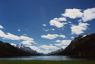
The Engadin or Engadine is a long high Alpine valley region in the eastern Swiss Alps in the canton of Graubünden in southeasternmost Switzerland with about 25,000 inhabitants. It follows the route of the Inn from its headwaters at Maloja Pass in the southwest running roughly northeast until the Inn flows into Austria, one hundred kilometers downstream. The En/Inn subsequently flows at Passau into the Danube, making it the only Swiss river to drain into the Black Sea. The Engadine is protected by high mountain ranges on all sides and is famous for its sunny climate, beautiful landscapes and outdoor activities.

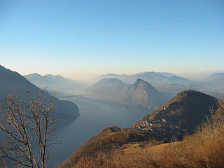
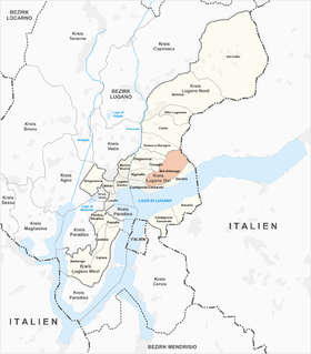
Lugano is a town and a municipality in southern Switzerland in the Italian-speaking canton of Ticino bordering Italy.

The Ossola[ˈɔssola] is an area of Italy situated to the north of Lago Maggiore. It lies within the Province of Verbano-Cusio-Ossola. Its principal river is the Toce, and its most important town Domodossola.

Monte Rosa is a mountain massif in the eastern part of the Pennine Alps. It is between Italy's and Switzerland's (Valais). Monte Rosa is the second highest mountain in the Alps and western Europe, after Mont Blanc.

Monte Generoso is a mountain of the Lugano Prealps, located on the border between Switzerland and Italy and between Lake Lugano and Lake Como. The western and southern flanks of the mountain lie in the Swiss canton of Ticino, whilst the north-eastern flanks are in the Italian region of Lombardy.

Monte Ceneri is a mountain pass in the canton of Ticino in Switzerland. It connects the Magadino plain and the Vedeggio valley across the Lugano Prealps at an elevation of 554 metres (1,818 ft) above sea level. In so doing, it provides the most direct route between the cities of Bellinzona and Lugano. Despite its name, Monte Ceneri is the lowest point on the crest between Monte Tamaro and the Camoghè.
Monte Brè is a small mountain east of Lugano on the flank of Monte Boglia with a view of the bay of Lugano and the Pennine Alps and the Bernese Alps. It is considered one of the sunniest points in Switzerland.
Piz Lunghin is a mountain in the Swiss canton of Graubünden, located in the Albula range, overlooking the Maloja Pass. It can be considered as the "roof of Europe" as the pass is nearby the triple watershed of the Lunghin pass. Water running off the mountain can head towards the Mediterranean or Black Sea.
Roveredo is a village and former municipality in the canton of Ticino, Switzerland.
Brè-Aldesago is a quarter of the city of Lugano, in the Swiss canton of Ticino.

The Monte Brè funicular, or Funicolare Cassarate - Monte Brè, is a funicular railway in the city of Lugano in the Swiss canton of Ticino. The line links a lower station in the Lugano suburb of Cassarate with an upper station at the summit of the Monte Brè. The top yields views of the city and Lake Lugano.

The Val Roseg is a valley of the Swiss Alps, located on the north side of the Bernina Range in the canton of Graubünden (Engadin). The valley is drained by the Ova da Roseg, a tributary of the Flaz, at Pontresina. Most of the valley is part of an exclave of the municipality of Samedan. Only the bottom of Val Roseg lies in the municipality of Pontresina.

Castagnola-Cassarate is a quarter of the city of Lugano, in the Swiss canton of Ticino.

The Cassarate is a river of the Swiss canton of Ticino. It rises in the upper part of the Val Colla, on the slopes of Monte Gazzirola and the San Lucio Pass. It flows into Lake Lugano at Lugano.
The Sopraceneri is that part of the Swiss canton of Ticino that lies to the north of the Monte Ceneri Pass through the Lugano Prealps. It includes the whole of the valley of the Ticino river and its side valleys, the Swiss shore of Lake Maggiore, the cities of Bellinzona and Locarno, as well as towns including Biasca and Riviera.

The Cima di Fojorina is a mountain of the Lugano Prealps, located on the border between Switzerland and Italy. It lies on the range separating the Val Colla from Lake Lugano.
Monte Bar is a mountain of the Lugano Prealps, located north of Lugano in the canton of Ticino, Switzerland. It lies on the range west of the Gazzirola, between the Val d'Isone and the Val Colla.

The border between the modern states of Switzerland and Italy extends for 744 kilometres (462 mi), from the French-Swiss-Italian tripoint at Mont Dolent in the west to the Austrian-Swiss-Italian tripoint near Piz Lad in the east. Much of the border runs across the High Alps, rising above 4,600 metres (15,100 ft) as it passes east of Dufourspitze, but it also descends to the lowest point in Switzerland as it passes Lago Maggiore at below 200 metres (660 ft).
The Monte Antoroto is a mountain of the Ligurian Alps located in Piedmont.
