
Ticino, sometimes Tessin, officially the Republic and Canton of Ticino or less formally the Canton of Ticino, is one of the 26 cantons forming the Swiss Confederation. It is composed of eight districts and its capital city is Bellinzona. It is also traditionally divided into the Sopraceneri and the Sottoceneri, respectively north and south of Monte Ceneri. Red and blue are the colours of its flag.

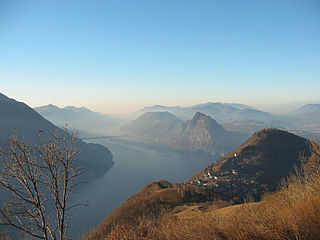
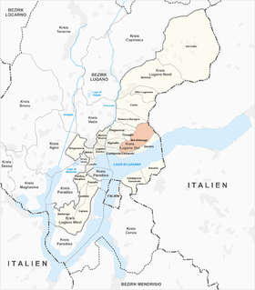
Lugano is a city and municipality in Switzerland, part of the Lugano District in the canton of Ticino. It is the largest city of both Ticino and the Italian-speaking southern Switzerland. Lugano has a population of 62,315, and an urban agglomeration of over 150,000. It is the ninth largest Swiss city.
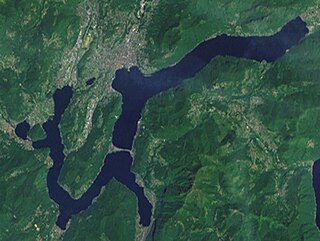
Lake Lugano is a glacial lake which is situated on the border between southern Switzerland and northern Italy. The lake, named after the city of Lugano, is situated between Lake Como and Lago Maggiore. It was cited for the first time by Gregory of Tours in 590 with the name Ceresio, a name which is said to have derived from the Latin word cerasus, meaning cherry, and refers to the abundance of cherry trees which at one time adorned the shores of the lake. The lake appears in documents in 804 under the name Laco Luanasco.

There are 108 municipalities in the canton of Ticino, Switzerland,. Municipalities (comuni) are grouped in circles (circoli) which are part of districts (distretti).

Porto Ceresio is a comune (municipality) on Lake Lugano in the Province of Varese in the Italian region Lombardy, located about 50 kilometres northwest of Milan and about 11 km (7 mi) northeast of Varese, on the border with Switzerland. As of 31 December 2020, it had a population of 2838 and an area of 5.1 square kilometres (2.0 sq mi).

Monte Generoso is a mountain of the Lugano Prealps, located on the border between Switzerland and Italy and between Lake Lugano and Lake Como. The western and southern flanks of the mountain lie in the Swiss canton of Ticino, whilst the north-eastern flanks are in the Italian region of Lombardy.

Monte Ceneri is a mountain pass in the canton of Ticino in Switzerland. It connects the Magadino Plain and the Vedeggio Valley across the Lugano Prealps at an elevation of 554 metres (1,818 ft) above sea level. It provides the most direct route between the cities of Bellinzona and Lugano. Despite its name, Monte Ceneri is the lowest point on the crest between Monte Tamaro and the Camoghè.
Monte Brè is a small mountain east of Lugano on the flank of Monte Boglia with a view of the bay of Lugano and the Pennine Alps and the Bernese Alps. It is considered one of the sunniest points in Switzerland.
Brè-Aldesago is a quarter of the city of Lugano, in the Swiss canton of Ticino.
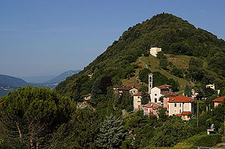
Brè is a village on the eastern slopes of the mountain of Monte Brè, in the Swiss canton of Ticino. Politically the village forms part of the Brè-Aldesago quarter of the city of Lugano, although until 1972 Brè-Aldesago was an independent municipality, known simply as Brè until 1953.

The Gazzirola is a mountain of the Lugano Prealps on the Swiss-Italian border. Its summit is the highest point of the municipality of Lugano.

The Monte San Salvatore is a mountain in the Lepontine Alps above Lake Lugano and the city of Lugano in Switzerland. The Monte San Salvatore funicular links the city with the summit of the mountain. The village on top of its peaks, Carona, is a popular destination to enjoy views over Lake Lugano and to walk through the exotic plants and flowers of Parco San Grato.

The Monte San Salvatore funicular, or Funicolare Monte San Salvatore, is a funicular railway in the city of Lugano in the Swiss canton of Ticino. The line links a lower station in the Lugano suburb of Paradiso with an upper station at the summit of the Monte San Salvatore. The top yields a 360° panorama with views of the city, Lake Lugano, Monte Generoso and the Italian enclave of Campione.

The Val Colla is a valley and a quarter of the city of Lugano in the Swiss canton of Ticino, to the north-east of the city of Lugano. It includes the localities of Bogno, Valcolla, Certara, Cimadera, Sonvico, which are all part of the city of Lugano, and the municipality of Capriasca.

Castagnola-Cassarate is a quarter of the city of Lugano, in the Swiss canton of Ticino.

The Cassarate is a river of the Swiss canton of Ticino. It rises in the upper part of the Val Colla, on the slopes of Monte Gazzirola and the San Lucio Pass. It flows into Lake Lugano at Lugano.
The Cima di Fojorina is a mountain of the Lugano Prealps, located on the border between Switzerland and Italy. It lies on the range separating the Val Colla from Lake Lugano.
Giovan Battista Lelli was an Italian painter.

The border between the modern states of Switzerland and Italy extends for 744 kilometres (462 mi), from the French-Swiss-Italian tripoint at Mont Dolent in the west to the Austrian-Swiss-Italian tripoint near Piz Lad in the east. Much of the border runs across the High Alps, rising above 4,600 metres (15,100 ft) as it passes east of Dufourspitze, but it also descends to the lowest point in Switzerland as it passes Lago Maggiore at below 200 metres (660 ft).

The Cinque Vette Park is a natural park, established by the Region of Lombardy on 19 June 2017. The park is located in the north-eastern part of the Province of Varese, in the Italian region of Lombardy. It takes the name from the main geographic features located in the park, the five mountain peaks. The project was launched with the aim of the three local councils of to preserve a green area and make it available for touristic-sportive-cultural initiatives above 500 meters of altitude. The primary goal of the park is to encourage the discovery of the natural features of the north-eastern part of Varese, which offers panoramic view points and preserves historical aspects such as: the remains of the Cadorna Line; the ruins of the Castle of Cuasso al Monte; the Artistic village of Boarezzo; the Saint Gemolo Abbey; the Alpine Village of Mount Piambello; and, the Hospital of Cuasso Al Monte.

