
Farmers Branch, officially the City of Farmers Branch, is a city in Dallas County, Texas, United States. It is an inner-ring suburb of Dallas and is part of the Dallas–Fort Worth metroplex. Its population was 35,991 at the 2020 census.
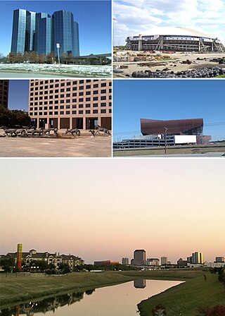
Irving is a city in Dallas County, Texas, United States. It is part of the Mid-Cities region of the Dallas–Fort Worth metroplex and is an inner city suburb of Dallas. Irving is noted for its racial and ethnic diversity. The city had a population of 256,684 according to the 2020 United States Census, making it the twelfth-most populous city in Texas, and the 88th most populous in the U.S. Irving includes the Las Colinas mixed-use master-planned community and part of the Dallas Fort Worth International Airport.

Little Elm is a city in Denton County, Texas, United States, and a part of the Dallas–Fort Worth metroplex. It is an extended suburb of Denton; its population was 46,453 as of the 2020 census. In 2000, the census population was at 3,646. By the 2010 census, the city total had jumped to 25,898, making Little Elm one of the fastest-growing municipalities by percentage in Texas since 2000. The July 1, 2022 census estimates Little Elm's population as 55,357.

The Colony is a city in Denton County, Texas, United States, and a suburb of Dallas. The population was 44,534 at the 2020 census.

Carrollton is a city in Dallas, Denton, and Collin counties in the U.S. state of Texas. As of the 2020 census, its population was 133,434, making it the 27th-most populous city in Texas.

Frisco is a city in the U.S. state of Texas, located in Collin and Denton counties. It is part of the Dallas–Fort Worth metroplex (DFW) and about 25 miles (40 km) from both Dallas Love Field and Dallas/Fort Worth International Airport. Its population was 200,509 in the 2020 U.S. census.

Coppell is a city in the northwest corner of Dallas County in the U.S. state of Texas. It is a suburb of Dallas and a bedroom community in the Dallas–Fort Worth metroplex. Its population was 42,983 at the 2020 census. A small area in the far northern portion of the city extends into neighboring Denton County.
Las Colinas is a mixed-use planned community development in Irving, Texas, part of the Dallas/Fort Worth Metroplex, governed by The Las Colinas Association, a Texas non-profit corporation. Due to its central location between Dallas and Fort Worth and its proximity to Dallas/Fort Worth International Airport and Dallas Love Field airport, Las Colinas has been a focus of corporate and business relocation.

The Dallas–Fort Worth metroplex, officially designated Dallas–Fort Worth–Arlington by the U.S. Office of Management and Budget, is the most populous metropolitan statistical area in the U.S. state of Texas and the Southern United States, encompassing 11 counties. Its historically dominant core cities are Dallas and Fort Worth. It is the economic and cultural hub of North Texas. Residents of the area also refer to it as DFW or the Metroplex. The Dallas–Fort Worth–Arlington metropolitan statistical area's population was 7,637,387 according to the U.S. Census Bureau's 2020 census, making it the fourth-largest metropolitan area in the U.S. and the eleventh-largest in the Americas. In 2016, the Dallas–Fort Worth metroplex had the highest annual population growth in the United States. By 2023, the U.S. Census Bureau estimated that the Dallas-Fort Worth metropolitan area's population had increased to 8,100,037, with the highest numerical growth of any metropolitan area in the United States.

Irving Independent School District is a school district based in Irving, Texas (USA). The district, which covers 48.5 square miles (126 km2), serves most of the city of Irving, except for Valley Ranch and a portion of Las Colinas. The district also serves small portions of Grand Prairie and Dallas.
Carrollton-Farmers Branch Independent School District (CFBISD) is a school district based in Carrollton, Texas, United States.
The President George Bush Turnpike (PGBT) is a 52-mile (84 km) controlled-access toll road running through the northern, northeastern and western suburbs, forming a partial beltway around Dallas, Texas, United States. It is named for the late George H. W. Bush, the 41st president of the United States. At its west end near Belt Line Road in Irving, State Highway 161 continues southwest to I-20 in Grand Prairie. The discontinuous free frontage roads along the turnpike from I-35E in Carrollton east to its end at I-30 in Garland are assigned the State Highway 190 designation. SH 190 signage appears only along the Rowlett, Garland, Richardson, Plano, and Carrollton sections of the frontage road with the undersign "frontage road only". At intersections with city streets, only the Bush Turnpike signs are displayed, not the SH 190 signage. Prior to the construction of the main lanes as a tollway, SH 190 was used as the name of the planned main lanes too. Similarly, the part west of I-35E was planned as part of SH 161. Bush Turnpike is signed as a north–south road from I-20 to I-35E, an east–west road from I-35E to the Merritt Main Lane Gantry and as a north–south road from the Merritt Main Lane Gantry to I-30, as Bush Turnpike makes a nearly 90-degree curve in both places.
The Mid-Cities is a suburban region filling the 30-mile span between Dallas and Fort Worth. These communities include the cities of Arlington, Bedford, Colleyville, Coppell, Euless, Flower Mound, Grand Prairie, Grapevine, Haltom City, Hurst, Irving, Keller, Lewisville, Mansfield, North Richland Hills, Richland Hills, Southlake, and Watauga.

The Dallas North Tollway is a 30.2-mile (49 km) controlled-access toll road operated by the North Texas Tollway Authority (NTTA), which runs from Interstate 35E near Downtown Dallas, Texas (USA), to U.S. Highway 380, in Frisco, Texas. On December 20, 2023, the NTTA announced the Tollway's next extension which runs 6 miles (9.7 km) through Prosper and Celina and ends at FM 428.

Ranchview High School is a public high school located in Irving, Texas (US). The school opened in 2002 as part of the Carrollton-Farmers Branch Independent School District (CFBISD). Ranchview serves students in Irving, Coppell, and Farmers Branch. Prior to Ranchview's opening, all students living west of Interstate 35E attended R.L. Turner High School.

The Coppell Independent School District is a school district based in Coppell, Texas (USA).

Circle Ten Council is a Boy Scouts of America (BSA) chartered council in central north Texas and a portion of Oklahoma. It encompasses all or parts of: Camp, Collin, Dallas, Delta, Ellis, Fannin, Franklin, Grayson, Henderson, Hopkins, Hunt, Kaufman, Lamar, Morris, Navarro, Rains, Red River, Rockwall, Titus, and Van Zandt counties in Texas as well as Bryan, Choctaw, McCurtain, and Pushmataha counties in Oklahoma. Founded in 1913 and based in Dallas, approximately 34,000 youth and 7,800 adults participate in Scouting through the council each year. The council has four camps - Camp Wisdom, Camp James Ray, Clements Scout Ranch / Camp Trevor Rees-Jones and Camp Constantin / Jack D. Furst Aquatics Base. The Order of the Arrow is represented by Mikanakawa Lodge.
Dallas, Texas, United States, has a number of universities, colleges, schools and libraries.
North Dallas is an area of numerous communities and neighborhoods in Dallas, Texas. The phrase "North Dallas" is also sometimes used to include any suburb or exurb north of Dallas proper within the metropolitan area. The majority of North Dallas is located in Dallas County, while a small portion is located in Collin and Denton counties. North Dallas generally includes areas of Dallas north of Northwest Highway, along with Lake Highlands and areas of Dallas north of IH-635 known as Far North Dallas. The area has strong social and economic ties to the Dallas enclave of Park Cities, and two inner suburbs of Dallas, Richardson and Addison.
Whispering Hills is a neighborhood consisting of 615 homes within the Lake Highlands neighborhood of Dallas, Texas adjacent to the suburbs of Richardson and Garland. It is generally bounded by Buckingham Rd along the Richardson border to the north, to the east by the Garland border near Plano Rd, to the south by Walnut St, and to the west by the KCS Railroad and Audelia Branch Greenbelt near Audelia Rd.
