
Oulu is a city and municipality of 208 939 inhabitants in the region of North Ostrobothnia, Finland. It is the most populous city in Northern Finland, and the fifth most populous in the country.
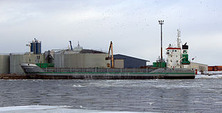
Port of Oulu is a complex of three separate harbours located at the mouth of Oulujoki river in Oulu, Finland. Port of Oulu is a corporation owned by the City of Oulu. Annual average of 3 million tons of cargo is shipped on 500 vessels. Two of the ports, Nuottasaari and Oritkari, are also rail-served.
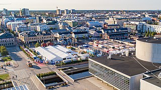
The Oulu Market Square is the main market square of the city of Oulu, Finland.

Tuira is a district of the city of Oulu, Finland. It is located north of city centre across the Oulujoki River. After the first bridges over Oulujoki connecting Tuira with Oulu were built in 1869, population growth of Tuira accelerated and Tuira was annexed by city of Oulu from the neighbouring rural municipality in 1886. Until the 1970s Tuira was a neighbourhood of wooden townhouses, but the new zoning plan of 1969 changed it to a suburb of residential tower blocks.

Pikisaari is a neighbourhood of the city of Oulu, Finland. The neighbourhood consists of Pikisaari and Korkeasaari islands connected due to the post-glacial rebound. Pikisaari is located near the city centre in the estuary of Oulujoki River in between market square and Hietasaari island.

Myllytulli is a district of the city centre area of Oulu, Finland.

Intiö is a district of the city centre area of Oulu, Finland. It is located on the southern bank of the Oulu River in between Myllytulli and Värttö districts.

Raksila is a District of the city centre area of Oulu, Finland. It is bounded by the Oulu railway station to the west, the Oulu Cemetery in the Intiö district to the north, the Finnish national road 4 to the east and the Finnish national road 22 to the south.

Koskikeskus is a neighbourhood in the Tuira area in the city of Oulu, Finland. The neighbourhood is located in the estuary of the river Oulujoki. The Tuira Bridges in Koskikeskus connect the city centre and Tuira neighbourhoods. The first bridges through the delta were built in late 1860s.

Hollihaka is a district of the city centre area of Oulu, Finland. It is bounded by the estuary of the Oulujoki river to the west, the Vanhatulli district to the north, the Leveri district to the east and the Nuottasaari district to the south. Together with the two latter districts, Hollihaka forms a neighbourhood called Heinäpää.
Pokkinen is a district of the city centre area of Oulu, Finland. Together with districts of Vaara and Vanhatulli, Pokkinen forms the central business district of Oulu. It is bounded by the estuary of the Oulujoki river to the west, the Koskikeskus and Myllytulli districts to the north, the Vaara district to the east and the Vanhatulli district to the south.
Vihreäsaari is an uninhabited island and a neighbourhood in the Tuira area in the city of Oulu, Finland. It is separated from the Hietasaari island by the Johteensalmi strait.

Vaara is a district of the city centre area of Oulu, Finland. Together with the districts of Pokkinen and Vanhatulli, Vaara forms the central business district of Oulu. It is bounded by the districts of Raksila to the east, Pokkinen to the west, Myllytulli to the north and Vanhatulli to the south.

Haukipudas is a district of Oulu, Finland. Together with Jokikylä and Martinniemi districts, it forms the Haukipudas area. Haukipudas is located in the river delta of the Kiiminkijoki river. It is bounded by the Bothnian Bay in the west, National road 4 in the east, Martinniemi district in the north and Kello district in the south. The district was established in 2013 when the Haukipudas municipality together with Kiiminki, Oulunsalo and Yli-Ii municipalities were merged with the city of Oulu.

Kiiminki is a district of Oulu, Finland. Together with Alakylä, Hannus and Huttukylä districts, it forms the Kiiminki area. The center of the district is located where the National road 20 crosses the Kiiminkijoki river. The district was established in 2013 when the Kiiminki municipality together with Haukipudas, Oulunsalo and Yli-Ii municipalities were merged with the city of Oulu.

Nuottasaari is a district of Oulu, Finland. It is located south of the city centre of Oulu. Nuottasaari is bounded by the delta of the Oulujoki river in the Northwest, the Bothnian Bay and the Äimärautio district in the South and the Limingantulli, Leveri and Hollihaka districts in the East.

Kontinkangas is a district of Oulu, Finland. It is located to the east of the National road 4 and to the north of the National road 22 about two kilometers from the city centre. Its neighbouring districts are Kaukovainio, Raksila, Peltola and Oulunsuu.

Karjasilta is a district in the Höyhtyä area in the city of Oulu, Finland. The district close to the city centre is bordered by the Raksila district to the north, Finnish national road 4 to the east, the Vanhatulli and Limingantulli districts to the west and the Nokela and Höyhtyä districts to the south.

Oulujoki is a former municipality of Finland. The municipality had a population of 5,230 (1963) and covered a land area of 606.1 square kilometres (234.0 sq mi). Its neighbouring municipalities were Kempele, Kiiminki, Muhos, Oulu, Tyrnävä, Utajärvi and Ylikiiminki. The municipality was named after the river Oulujoki.

Martinniemi is a district of Oulu, Finland. Together with Haukipudas and Jokikylä districts, it forms the Haukipudas area. Martinniemi is located in north of the river delta of the Kiiminkijoki river. It is bounded by the Bothnian Bay in the west, the Jokikylä district in the east, the Ii municipality in the north and the Kiiminkijoki river and the Haukipudas district in the south. The district was established in 2013 when the Haukipudas municipality together with Kiiminki, Oulunsalo and Yli-Ii municipalities were merged with the city of Oulu.
