
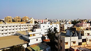
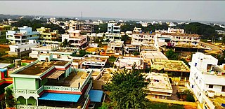
Nellore is a city located on the banks of Penna River, in Nellore district of the Indian state of Andhra Pradesh. It serves as the headquarters of the district, as well as Nellore mandal and Nellore revenue division. It is the fourth most populous city in the state. It is at a distance of 279 kilometres (173 mi) from Vijayawada and about 170 km (110 mi) north of Chennai, Tamil Nadu and also about 380 km (240 mi) east-northeast of Bangalore, Karnataka.
Yerradoddipalli, also written Yerramreddipalle, is a small village in Sri Potti Sriramulu Nellore district of Andhra Pradesh state in India.
Kavali is a town in Nellore district of Andhra Pradesh of India. It also serves as headquarters of Kavali mandal and Kavali revenue division.It is one of the few cities from Andhra Pradesh which were selected for Atal Mission for Rejuvenation and Urban Transformation (AMRUT) Scheme.

Nellore district, officially known as Sri Potti Sriramulu Nellore district in Coastal Andhra Region, is one of the 26 districts in the Indian state of Andhra Pradesh. According to the 2011 Census, the district's population was 2,469,712 of which 29.07% was urban. Its administrative headquarters are located in Nellore city. Located in the Coastal Andhra region, the district is bordered by the Bay of Bengal to the east, Kadapa district and Annamayya district to the west, Prakasam district to the north, and Tirupati district to the south.

Kovur is a village in Nellore district of the Indian state of Andhra Pradesh. The village is also the headquarters of the Kovur Mandal and Assembly Constituency. It is located in Kovur mandal of Nellore revenue division. It forms a part of Nellore Urban Development Authority. The poet "Thikkanna" was born in this place.
Kandukur or Kandukuru is a town in SPSR Nellore district of the Indian state of Andhra Pradesh. It is a municipality and the headquarters of Kandukur mandal as well as Kandukur revenue division. Kandukur Mandal is located at the south-east side of the Prakasam District having geographical area around 225 km2.There is only 1 city in the Kandukur Mandal, which is Kandukur Municipality having an area of 37.63 km2.

Nelli-marla is a census town in Vizianagaram district of the Indian state of Andhra Pradesh. It is in Nellimarla mandal of Vizianagaram revenue division.

Pakala is a town in Tirupati district of the Indian state of Andhra Pradesh. It is the mandal headquarters of Pakala mandal. It comes under Tirupati revenue division.

Narasannapeta is a census town in Srikakulam district of the Indian state of Andhra Pradesh. It is the mandal headquarters of Narasannapeta mandal in Srikakulam revenue division. 43 villages are there under the administrative division of Narasannapeta.
Ananthasagaram is a village and a Mandal in Nellore district in the state of Andhra Pradesh in India.
Chejerla is a village and a Mandal in Nellore district in the state of Andhra Pradesh in India.
Duttalur or Duthalur is a village and a mandal in Nellore district in the state of Andhra Pradesh in India.
Kaligiri is a town in Nellore district in the Indian state of Andhra Pradesh it is the mandal headquarters of Kaligiri Mandal in India.
Kaluvoya or Kaluvaya is a village and a Mandal in Nellore district in the state of Andhra Pradesh in India.

Sangam is a village on the bank of Penna River and a Mandal in Nellore district in the state of Andhra Pradesh in India. The village of Chennavarappadu is nearby to the north.

Udayagiri is a town in Udayagiri Mandal in the Nellore district of the state of Andhra Pradesh in India.
Nellore mandal is one of the 46 mandals in Nellore district of the state of Andhra Pradesh, India. Its headquarters are located at Nellore. The mandal is bounded by Sangam, Butchireddipalem, Indukurpet, Kovur, Podlakur, Thotapalligudur, Venkatachalam and Muthukur mandals.
Gudur mandal is one of the 34 mandals in Tirupati district of the state of Andhra Pradesh, India. Its headquarters are located at Gudur. The mandal is situated on the coast of Bay of Bengal, bounded by Sydapuram, Manubolu, Balayapalle, Ojili and Chillakur mandals. It is a part of Gudur revenue division.

Allur is a Town it is the Nagara panchayat in Nellore district of the Indian state of Andhra Pradesh. It is under the administration of Kavali revenue division and the headquarters are located at Allur.
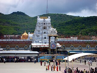
Tirupati district is one of the eight districts of Rayalaseema region in the Indian state of Andhra Pradesh. The district headquarters is located at Tirupati city. This district is known for its numerous historic temples, including the Hindu shrine of Tirumala Venkateswara Temple and Sri Kalahasteeswara temple. The district is also home to Satish Dhawan Space Centre, a rocket launch centre located in Sriharikota. The river Swarnamukhi flows through Tirupati, Srikalahasti, Naidupeta, Vakadu and join into the Bay of Bengal.


