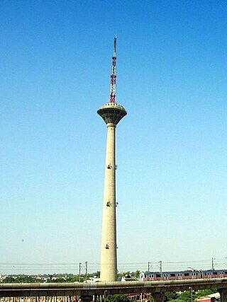
Pitampura is a residential area in North West Delhi district of Delhi, India. It is located adjacent to Rohini. It is a planned neighbourhood developed by the Delhi Development Authority in the 1980s and Pitampura TV Tower, was built in 1988. Dilli Haat Pitampura is also situated near the TV tower. Situated in west Delhi, it is an upscale residential, commercial and retail centre. The area is encompassed between Outer and Inner Ring Roads, NH-1 and Rohtak Road. It has two wards, Pitampura and Pitampura North, under the Rohini zone of Municipal Corporation of Delhi.

Mayur Vihar is an upmarket residential area on the periphery of Delhi, located in East Delhi, close to the city's Noida-Delhi border, situated just across the Yamuna River, and is divided into three distinct phases (sectors). As the name suggests, it has been the dwelling (vihar) of peacocks (mayur). Even today, the area has a closed sanctuary dedicated to the conservation of peacocks.
Ramakrishna Puram popularly known as R.K. Puram, is a residential colony in Delhi. Named after the saint Sri Ramakrishna, it houses many high-profile corporate houses.

Saket is a residential colony and the administrative headquarters of the South Delhi district of Delhi in India. The neighborhood is named after the city of Ayodhya, also known as Saket, an ancient, religiously significant city in Uttar Pradesh.
Rajouri Garden is a market and residential neighbourhood in South-West Delhi, India. The Main Market and Nehru Market are the key markets of the area. The population is largely Punjabi who migrated to Delhi, following the Partition of India, from Pakistan in 1947. The postal code of Rajouri Garden is 110027.
Patparganj is a locality situated in East Delhi District of the National Capital Territory of Delhi, India, and is located near the border with Uttar Pradesh.
Karawal Nagar is a census town in North East Delhi, India.

East Delhi is an administrative district of Delhi in India. It is bounded by the Yamuna River on the west, North East Delhi to the north, Ghaziabad District of Uttar Pradesh state to the east, and Gautam Buddha Nagar District of Uttar Pradesh to the south. Administratively, the district is divided into three subdivisions: Gandhi Nagar, Preet Vihar, and Mayur Vihar.
Dallupura is a village on the outskirts of the Trans-Yamuna region of Delhi, India. It is situated near Uttar Pradesh (UP) New Okhla Industrial Development Authority(NOIDA) border alongside Vasundhra Enclave and Kond Hindon canal runs along one side of the village. It is well connected to Noida, Ghaziabad and rest of the Delhi. It falls under Kondli legislative assembly constituency(Reserved) and East Delhi parliamentary constituency. This village is surrounded by 56 CGHS Societies and has good infrastructure facilities. Dharamshila Hospital lies on the outskirts of the village. Four schools are adjacent to this village, namely Cosmos Public School, Evergreen Public School, Somerville School and Starex International School, Dashmesh Public School. Maharaja Agrasen College, affiliated to Delhi University (DU), is also situated in this region. The closest Metro station is 2 km from the village. One is New Ashok Nagar Metro station and the other is Noida sec.15 Metro Station.
Babar pur is the area surrounded by Yamuna Vihar in north, Maujpur in west, Seelampur in south and Chhajjupur in east. It is situated in the region of North Shahdara of Delhi. It is connected to Main 100 feet road to Ashok Nagar. It is located near Ghaziabad-Loni Border.

Gandhi Nagar is a residential area in the East Delhi district of Delhi in the Trans-Yamuna area. It is most known for Gandhi Nagar Market, which is Asia's biggest readymade garments/textile market. Gandhi Nagar has many shops and factories.
Laxmi Nagar, is the central location and focal point for east Delhi area. Earlier, it was one of the most inhabited cities, known as Trans Yammuna. It has become a popular shopping area for garments, and day to day staple items.

The New Ashok Nagar Metro Station is a metro station on the Blue Line of the Delhi Metro.

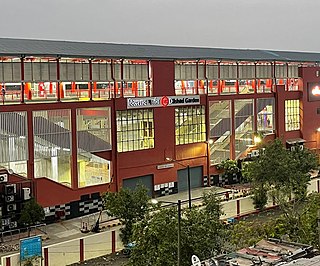
The Dilshad Garden metro station is a station of the Red Line of the Delhi Metro. It was the terminal station of the Red Line till 7 March 2019.

Anand Vihar is an interchange metro station located on the Blue and Pink lines of the Delhi Metro. Anand Vihar served as the terminus of the Blue line until July 13, 2011. The station is situated in the locality of Anand Vihar, near the interstate border between Delhi and Uttar Pradesh, and functions as a major connectivity hub for East Delhi. It is seamlessly integrated with the Anand Vihar ISBT and the Anand Vihar Terminal of Indian Railways. The upcoming RapidX station at Anand Vihar will further enhance connectivity, providing faster transit options to neighbouring cities and boosting intermodal transportation links in the region.

The Hauz Khas metro station is an interchange station between the Yellow Line and the Magenta Line of the Delhi Metro. It serves Hauz Khas Enclave, Sarvapriya Vihar, Vijay Mandal Enclave, RBI colony, Mayfair Gardens and the IIT Delhi. The entrance to the station is located on Outer Ring Road, to the east of Aurobindo Marg and to the west of Khelgaon Marg.
Ashok Vihar is a neighbourhood in the North West Delhi district of Delhi, India. Situated along the Ring Road, Delhi, it is divided into four phases.
Mayur Vihar Phase-3 is the third phase of the Mayur Vihar residential area in East Delhi. It lies in Kondli constituency close to the Noida border on one side and New Kondli and Gharoli on the other. It lies adjacent to Vasundhara Enclave, another prominent residential area of East Delhi. It lies on the eastern border of Delhi and shares Border of Uttar Pradesh with Noida as well as Khora Colony, a cluster of urban settlements bordering Ghaziabad. The Pincode of this area is 110096.
Okhla Vihar is a new settlement in Okhla, in the district of South East Delhi, India. It consists of many lanes (roads) and many sub-lanes (sub-roads). Over 80% of the area of Okhla Vihar is covered with 5-story apartments. The area consists of three mosques and a church. Amanatullah Khan is the local M.L.A from AAP.


