Vayyattupuzha

Last updated

Vayyattupuzha
village
India Kerala location map.svg
Red pog.svg
Vayyattupuzha
Location in Kerala, India
India location map.svg
Red pog.svg
Vayyattupuzha
Vayyattupuzha (India)
Coordinates: 9°18′39″N76°57′24″E / 9.31083°N 76.95667°E / 9.31083; 76.95667 Coordinates: 9°18′39″N76°57′24″E / 9.31083°N 76.95667°E / 9.31083; 76.95667
CountryFlag of India.svg  India
State Kerala
District Pathanamthitta
Government
  Type Panchayath
Languages
  Official Malayalam, English
Time zone UTC+5:30 (IST)
PIN
689663
Vehicle registration KL-62, KL-03

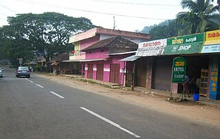
Vayyattupuzha is a village situated near to Chittar in Pathanamthitta district, Kerala. Its predominantly a rural hilly area but is very famous for spice trade.

Chittar, Kerala town/village in Kerala, India

Chittar is a village in Pathanamthitta district, located in Kerala state, India. It is a Panchayat and is situated in the Ranni taluk and in Konni constituency in Pathanamthitta District. It is located 29 km away from Pathanamthitta town at its east. Nearby Panchayats are Seethathodu, Perunad, Vadaserikkara and Thannithodu. Formerly Chittar was included in the Ranni legislative assembly constituent, but now in Konni assembly. Also previous parliament constituent was Idukki and currently it is Pathanamthitta.Chittar also awarded' Nirmal gram ' award from former president Prathibha patel.

Pathanamthitta district District in Kerala, India

Pathanamthitta District is a district in the southern part of Kerala, India. The district headquarters is in the town of Pathanamthitta. There are four municipalities in Pathanamthitta: Tiruvalla, Adoor, Pathanamthitta and Pandalam.

Kerala State in southern India

Kerala is a state on the southwestern Malabar Coast of India. It was formed on 1 November 1956, following passage of the States Reorganisation Act, by combining Malayalam-speaking regions. Spread over 38,863 km2 (15,005 sq mi), Kerala is the twenty-second largest Indian state by area. It is bordered by Karnataka to the north and northeast, Tamil Nadu to the east and south, and the Lakshadweep Sea to the west. With 33,387,677 inhabitants as per the 2011 Census, Kerala is the thirteenth-largest Indian state by population. It is divided into 14 districts with the capital being Thiruvananthapuram. Malayalam is the most widely spoken language and is also the official language of the state.

See also

Nilakkal village in Kerala, India

Nilakkal, also spelled Nilackal, or formerly Chayal, is a remote ghat region located in the Goodrical range of Ranni forest division in Pathanamthitta District in the Indian state of Kerala. The place is noted mainly as an edathavalam or halting-place for the Ayyappa devotees during Sabarimala pilgrimage. Administratively, it falls under the Perunad grama panchayath in Ranni tehsil. Sabarimala, the famous Hindu pilgrim centre in South India is located at a distance of 23 km (14 mi) in the north-east hilly region of Nilakkal.

Uthimoodu Town in Kerala, India

Uthimoodu is a small village in Pathanamthitta district of the Indian state of Kerala.

Seethathodu Village/town in Kerala, India

Seethathodu is a village in the Pathanamthitta district, state of Kerala, India, near Chittar Town. Predominantly it is a rural region where agriculture being the most important sector. Both state-run and privately operated buses connect Seethathodu to various parts of Pathanamthitta district.

Related Research Articles

Kozhencherry town in Kerala, India

Kozhencherry is a census town in Pathanamthitta district of Central Travancore region in Kerala state, South India. As of 2011 census, the population was 12,021 people in 3,393 households.It is one of the main city in the Pathanamthitta, District. It is on the banks of Pampa river. It is a commercial centre and many banks and trade companies have their establishments here. It is believed that once the Kovilans of Thekencore kingdom's ruled this area. Kozhencherry used to be a part of the erstwhile Travancore kingdom.

Pamba River river in India

The Pamba River is the third longest river in the South Indian state of Kerala after Periyar and Bharathappuzha and the longest river in the erstwhile princely state of Travancore. Sabarimala temple dedicated to Lord Ayyappa is located on the banks of the river Pamba. In old Hindu Epics, Pampa was Lord Brahma's daughter, who was later married to Lord Shiva.

Konni, Kerala Place in Kerala, India

Konni is a major town and a Taluk headquarters in Pathanamthitta district, Kerala, India. Konni is known for its elephant cages, forests, and rubber plantations.Konni is Also Known as "Anakoodinte Nadu".

Chittar River and its five tributaries and numerous other contributing streams originate in the Courtallam hills of Tirunelveli District in the state of Tamil Nadu in southern India. Together with its tributaries and streams, the Chittar River serves as an important source of irrigation for the region and is a major tributary of the Tambaraparani River along with the Manimuthar River.

Vadasserikara Town in Kerala, India

Vadaserikara is a village in Pathanamthitta district, in the state of Kerala, India. It is one of the 11 villages in Ranni and sits at the confluence of the Pamba and Kallar Rivers.

Erumely Town/village in Kerala, India

Erumely, also spelt "Erumeli" is a village and town in the southeast part of Kottayam district in Kerala state, India. It is situated on the way to Sabarimala and also an important halting place (idathavalam) for the Sabarimala pilgrims. Erumely is famed for its religious harmony and prosperity between Hindus and Muslims which existed from the early periods. It is a place which have strong roots in legends and myths associated with lord Ayyappa. A new airport has been proposed in Erumeli. The city is nourished by Manimala River.

Perunad (Ranni-Perunad) is a scenic hilly village in Pathanamthitta district, Kerala state, India It's located on the banks of Pamba River and Kakkadu River.

Lahai, Kerala Village in Kerala, India

Lahai, also spelt Laha is a remote settlement located in the north eastern part of Pathanamthitta district, Kerala state, India. This is the place from which the sacred grove (Poongavanam) of Lord Ayyappa begins.

Gavi, Kerala Village in Kerala, India

Gavi is a village in Pathanamthitta district, Kerala, India. It is located 28 km southwest of Vandiperiyar, a town in Idukki on N.H 220, the highway connecting Kollam and Madurai.

Angamoozhy Town/village in Kerala, India

Angamoozhy is a village in Pathanamthitta district in the Indian state of Kerala. Angamoozhy is located near the Kakkad power station and the Sabarimala temple. Geographically Angamoozhy is High-range area.

Aluthakanniar is a river flowing in the Tirunelveli district of the Indian state of Tamil Nadu. It is one of the tributaries of Chittar River, which joins Tamiraparani near Tirunelveli. It arises in the eastern slopes of the Western Ghats, and forms the Old Kutralam falls as it descends down the mountain. It flows 10 kilometres (6 mi) towards northeast before joining its main river Chittar near Kadapagothi village.

Thulappally village in Kerala, India

Thulappally is a small village in Perunad panchayath of Ranni tehsil in Pathanamthitta district of Kerala state, India..

This District has four types of administrative hierarchies:

Manakkayam village in Kerala, India

Manakkayam is a small village located near Chittar in Pathanamthitta district of Kerala state, India. It lies on the Puthukkada - Chittar road, about 5 kilometres (3.1 mi) from Puthukkada, 3 kilometres (1.9 mi) from Chittar and 7 kilometres (4.3 mi) from Seethathodu.

References