The Godavari is India's second longest river after the Ganges river and drains into the third largest basin in India, covering about 10% of India's total geographical area. Its source is in Trimbakeshwar, Nashik, Maharashtra. It flows east for 1,465 kilometres (910 mi), draining the states of Maharashtra (48.6%), Telangana (18.8%), Andhra Pradesh (4.5%), Chhattisgarh (10.9%) and Odisha (5.7%). The river ultimately empties into the Bay of Bengal through an extensive network of tributaries. Measuring up to 312,812 km2 (120,777 sq mi), it forms one of the largest river basins in the Indian subcontinent, with only the Ganga and Indus rivers having a larger drainage basin. In terms of length, catchment area and discharge, the Godavari is the largest in peninsular India, and had been dubbed as the Dakshina Ganga.

Krishna district is district in the coastal Andhra Region in Indian state of Andhra Pradesh, with Machilipatnam as its administrative headquarters. It is the coastal district of Andhra Pradesh. Machilipatnam is the most populated city in the district. It is surrounded on the east by Bay of Bengal, west by Guntur and north by Eluru and NTR districts and south again by Bay of Bengal. In 2022 Krishna district was divided into Krishna and NTR districts.

East Godavari is a district in the Coastal Andhra region of Andhra Pradesh, India. Its district headquarters is at Rajahmundry. As of census 2011, it became the most populous district of the state with a population of 5,151,549.

Rajahmundry, officially known as Rajamahendravaram, is a city in the Indian state of Andhra Pradesh and District headquarters of East Godavari district. It is the sixth most populated city in the state. During British rule, the District of Rajahmundry was created in the Madras Presidency in 1823. It was reorganised in 1859 and bifurcated into the Godavari and Krishna districts. Rajahmundry was the headquarters of Godavari district, which was further bifurcated into East Godavari and West Godavari districts in 1925. When the Godavari district was bifurcated, Kakinada became the headquarters of East Godavari and Eluru became the headquarters of West Godavari. It is administered under Rajahmundry revenue division of the East Godavari district. The city is known for its floriculture, history, culture, agriculture, economy, tourism, and its heritage. It is known as the "Cultural Capital of Andhra Pradesh".

The West Godavari district is a coastal district in the Indian state of Andhra Pradesh with an administrative headquarters in Bhimavaram. As of the 2011 Census of India, the district has an area of 7,742 km2 (2,989 sq mi) and a population of 3,936,966. It is bounded by the Krishna district and Bay of Bengal to the south, East Godavari district to the east, and Eluru district, Kolleru Lake and Upputeru Drain to the northwest.

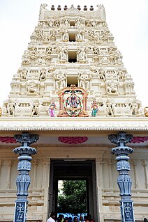
Dwaraka Tirumala is a census town in Eluru district of the Indian state of Andhra Pradesh. It is located in Dwaraka Tirumala mandal of Jangareddygudem revenue division. The Venkateswara Temple is a pilgrimage center for hindus, which is the abode of Lord Venkateswara. This is often referred by the locals as Chinna Tirupati, meaning mini Tirupati.
Koyyalagudem is a mandal in West Godavari district of the Indian state of Andhra Pradesh. Koyyalagudem comes under Jangareddygudem revenue division.

Hanuman Junction is a town which lies between the borders of Krishna and Eluru District of Andhra Pradesh state in India. Hanuman Junction gets its name because it is located in the X-Junction of NH-16 & AH-45.

Pakala is a town in Tirupati district of the Indian state of Andhra Pradesh. It is the mandal headquarters of Pakala mandal. It comes under Tirupati revenue division.
Budameru is a rivulet in NTR district which originates in the hills surrounding Mylavaram and empties itself into Kolleru Lake. Budameru is also known as The Sorrow of Vijayawada. In order to control the floods, the river was dammed at Velagaleru village and a diversion channel named, Budameru Diversion Channel (BDC) was constructed from Velagaleru to join Krishna River upstream of Prakasam Barrage.
Chintalapudi is a town municipality and mandal headquarters in Eluru District of the Indian state of Andhra Pradesh.

Unguturu is a village in Eluru district of the Indian state of Andhra Pradesh. It is located in Unguturu mandal of Eluru revenue division. Vasuki Sunkavalli of this village was elected Miss India Universe in 2011. It is located 12 km from the nearest town, Tadepalligudem. As per the 2011 census of India, the village is spread over 4405 hectares with 3912 houses and a population of 14280. The number of males in the village is 7143, the number of females is 7137. The number of Scheduled Castes is 3349 and the number of Scheduled Tribes is 130.

Andhra Pradesh is a state in India. Andhra Pradesh Tourism Development Corporation (APTDC) is a state government agency which promotes tourism in Andhra Pradesh, describing the state as the Koh-i-Noor of India. Andhra Pradesh has a variety of tourist attractions including beaches, hills, caves, wildlife, forests and temples.

The Polavaram Project is an under construction multi-purpose irrigation project on the Godavari River in the Eluru District and East Godavari District in Andhra Pradesh. The project has been accorded National project status by the Central Government of India. Its reservoir back water spreads up to the Dummugudem Anicut and approx 115 km on Sabari River side. Thus back water spreads into parts of Chhattisgarh and Odisha States. It gives major boost to tourism sector in Godavari Districts as the reservoir covers the famous Papikonda National Park, Polavaram hydro electric project (HEP) and National Waterway 4 are under construction on left side of the river. It is located 40 km to the upstream of Sir Arthur Cotton Barrage in Rajamahendravaram City and 25 km from [[Rajahmundry Airport.

Tetagunta is one of the villages in Tuni Mandal in Kakinada district in Andhra Pradesh State and is located 14.1 km from its Mandal main town Tuni. It is 44.3 km from its district main city Kakinada. It has a population of 11,967 and people mostly depend on farming. Tetagunta village of Tuni Mandal is having the largest area of 4,033 hectares in the East Godavari District.It is located at a distance of 120 km from the state main city Visakhapatnam. Pincode:533406

Balive is a village in the Krishna district of the Indian state of Andhra Pradesh. It is located in Musunuru Mandal, of Nuzvid revenue division. It is approximately 15 km from Eluru city in West Godawari District.
Ganapavaram mandal is one of the 28 mandals in Eluru district of the Indian state of Andhra Pradesh. It is under the administration of Eluru revenue division and the headquarters are located at Ganapavaram. Ganapavaram Mandal is bounded by Nidamarru Mandal towards west, Pentapadu Mandal towards North, Undi Mandal towards South, Unguturu Mandal towards North. Tadepalligudem, Bhimavaram, Tanuku, Eluru are the nearby Cities to Ganapavaram. It is located 55 km from Eluru and 22 km from Bhimavaram.
Chintalapudi mandal is one of the 28 mandals in Eluru district of the Indian state of Andhra Pradesh. It is administered under Nuzvidu revenue division and its headquarters are located at Chintalapudi. The mandal is bounded by T.Narasapuram mandal, Lingapalem mandal, Khammam district
Lingapalem Mandal is one of 28 mandals in the Eluru district of Andhra Pradesh in India. Its headquarters are located in Lingapalem. It is bordered by T.Narasapuram and Chintalapudi in the North, Khammam district tin the West, Kamavarapukota mandal in the East, and Pedavegi mandal in the South.

Eluru district is a district in coastal Andhra Region in the Indian state of Andhra Pradesh. With Eluru as its administrative headquarters, it was proposed on 26 January 2022 to become one of the resultant twenty six districts in the state once a final notification is issued by the government of Andhra Pradesh. It is formed from Eluru revenue division and Jangareddygudem revenue division from West Godavari district and Nuzvid revenue division from Krishna district.


