
In geography and geology, a cliff is an area of rock which has a general angle defined by the vertical, or nearly vertical. Cliffs are formed by the processes of weathering and erosion, with the effect of gravity. Cliffs are common on coasts, in mountainous areas, escarpments and along rivers. Cliffs are usually composed of rock that is resistant to weathering and erosion. The sedimentary rocks that are most likely to form cliffs include sandstone, limestone, chalk, and dolomite. Igneous rocks such as granite and basalt also often form cliffs.

Plitvice Lakes National Park is one of the oldest and largest national parks in Croatia. In 1979, Plitvice Lakes National Park was inscribed on the UNESCO World Heritage list, due to its outstanding and picturesque series of tufa lakes, caves, connected by waterfalls.

The Paklenica karst river canyon is a national park in Croatia. It is near Starigrad, northern Dalmatia, on the southern slopes of Velebit mountain, not far from Zadar. It contains two canyons, Mala (Small) and Velika (Big) Paklenica. Today there is no water flowing through Mala Paklenica. Near the entrance to the Velika Paklenica is an artificial tunnel complex built for Josip Broz Tito during the tension between Yugoslavia and the USSR in the late 1940s and early 1950s.

Split-Dalmatia County is a central-southern Dalmatian county in Croatia. The administrative center is Split. The population of the county is 455,242 (2011). The land area is 14.106,40 km2. Split-Dalmatia County is Croatia's most rapidly urbanising and developing region, as economic opportunities and living standards are among the highest alongside capital Zagreb and Istria County.

San Jacinto Peak is a 10,834 ft (3,302 m) peak in the San Jacinto Mountains, in Riverside County, California. Lying within Mount San Jacinto State Park it is the highest both in the range and the county, and serves as the southern border of the San Gorgonio Pass. Naturalist John Muir wrote of San Jacinto Peak, "The view from San Jacinto is the most sublime spectacle to be found anywhere on this earth!"

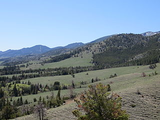
The Žumberak Mountains is a range of hills and mountains in northwestern Croatia and southeastern Slovenia, extending from the southwest to the northeast between the Krka and the Kupa.
Dinara is a 100-kilometre-long (60-mile) mountain range in the Dinaric Alps, located on the border of Bosnia and Herzegovina and Croatia. It has four major mountains or peaks, from north-west to south-east:

Velebit is the largest, though not the highest, mountain range in Croatia. The range forms a part of the Dinaric Alps and is located along the Adriatic coast, separating it from Lika in the interior. Velebit begins in the northwest near Senj with the Vratnik mountain pass and ends 145 km to the southeast near the source of the Zrmanja river northwest of Knin.

Konavle is a municipality and a small region located southeast of Dubrovnik, Croatia.
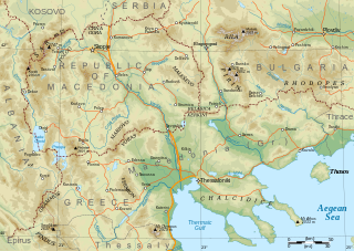
Mariovo is a historic region in the southern part of North Macedonia, with an area of 1,390 square km and an elevation 1,050 m, situated among mountains.
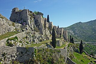
Klis is a Croatian municipality located around a mountain fortress bearing the same name. It is a suburb of Split located in the region of Dalmatia, located just northeast of Solin and Split proper near the eponymous mountain pass. It has a population of 3,001, totalling 4,801 together with the eight other villages in its municipality.
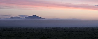
The Wet Mountains are a small mountain range in southern Colorado, named for the amount of snow they receive in the winter as compared to the dried Great Plains to the east. They are a sub-range of the Sangre de Cristo Mountains, in the southern Rocky Mountains System. There are three variant names of mountain range: Cuerno Verde, Greenhorn Mountains, and Sierra Mojada.
Cliff Mountain is a mountain located in Essex County, New York. The mountain is part of the Marcy Group of the Great Range of the Adirondack Mountains. Cliff is flanked to the southeast by Mount Redfield.

Kozjak is a mountain situated on the border between North Macedonia and Serbia. It is situated north-east from Kumanovo. The tallest peak of Kozjak is Virovi at 1284 meters. The region is also known as Kozjačija (Козјачија). The river Pčinja flows along the western edge of the mountain.

Svilaja is a mountain range in Croatia, in the Dalmatian Hinterland.

Kozjak, also known as Mali Kozjak or Primorski Kozjak is a mountain located above the town of Kaštela in Dalmatia, Croatia.
Kozjak is a common South Slavic toponym derived from koza ("goat") that may refer to:

Gornji Dolič is a village in the Municipality of Mislinja in northern Slovenia. The area is part of the traditional region of Carinthia and is now included in the Carinthia Statistical Region.
The Peacock Mountains are a small, 26 mi (42 km) long mountain range in northwest Arizona, US. The range is a narrow sub-range, and an extension north, at the northeast of the Hualapai Mountains massif, which lies to the southwest. The range is defined by the Hualapai Valley to the northwest, and north and south-flowing washes on its east border, associated with faults and cliffs; the Cottonwood Cliffs are due east, and are connected to the Aquarius Cliffs southward at the west perimeter of the Aquarius Mountains; the cliffs are a result of the Aquarius Fault, which is an extension southward from the Grand Wash Cliffs and Grand Wash Fault which crosses the Colorado River at Lake Mead, and the west perimeter of the Grand Canyon/Colorado Plateau.
The Ferris Mountains are a small mountain range in Carbon County, Wyoming. A high white cliff undulates along the entire length of the south side of the range, making it uniquely noticeable. The cliff is predominantly visible from U.S. Route 287. The highest peak in the range is Ferris Peak, which rises to an elevation of 10,037 feet (3,059 m). Ferris peak stands 3,000 feet (910 m) above the surrounding valley, and is the highest peak in the Great Divide Basin.

