
Nizamabad, also known as Induru, is a city in the Indian state of Telangana. It is governed by municipal corporation and is the headquarters of the Nizamabad district. Although previously part of Hyderabad State and then Andhra Pradesh state, Nizamabad became a part of the newly formed state of Telangana by the Andhra Pradesh Reorganisation Act, 2014. It is located about 186 kilometres (116 mi) north of the state capital, Hyderabad.

Nizamabad district is a district located in the north-western region of the Indian state of Telangana. The city of Nizamabad is the district headquarters. The district share boundaries with Jagtial, Sircilla, Nirmal, Kamareddy districts and with Nanded district of the state boundary of Maharashtra.

Nizamabad Lok Sabha constituency is one of the 17 Lok Sabha constituencies in Telangana state in southern India.
Armoor is a city in Nizamabad district, in the state of Telangana in India. Armoor is situated on NH 63. In the past, it was called Navanathapuram since it has nine mountains around the city Armoor is a variation of it.
National Highway 63 is a National Highway in India, total length 860 km (530 mi). It passes through the states of Maharashtra, Telangana, Maharashtra, Chhattisgarh & Odisha.
Nizamabad, Nezamabad, or Nazmabad, may refer to:
Nizamabad is a small town near Wazirabad in Gujranwala District, Punjab, Pakistan. It is about a kilometer from Wazirabad towards Lahore. And 100 km from lahore, 40 km from Gujranwala

Telangana University is a public university located at Dichpally in Nizamabad,Telangana, India, established in 2006.
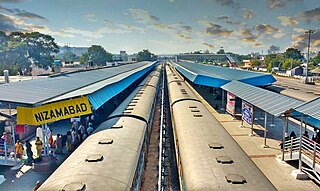
Nizamabad Junction railway station is an Indian Railways station, which serves the city of Nizamabad in Telangana. It is a major station on Secunderabad–Manmad railway line, also serving as the junction point for Secunderabad, Peddapalli, Jankampet/Mudkhed junctions. It is administered under Hyderabad railway division of South Central Railway zone. Jankampet Junction railway station is another station located in the city from where the Secunderabad–Manmad line branch towards Bodhan.

Peddapalli–Nizamabad line is a single-track broad-gauge railway line in the Indian state of Telangana. It connects Nizamabad and Peddapalli in South Central Railway zone. It reduces the distance between Nizamabad, Karimnagar and Warangal. Peddapalli is located on Kazipet–Balharshah section of Delhi–Chennai line, known as Grand Trunk line and Nizamabad is located on Secunderabad–Manmad line. The line roughly follows National Highway 63 from Jagtial to Nizamabad.
Nizamabad Airport is a proposed greenfield airport in Jakranpalli in Nizamabad district in the Indian state of Telangana. The project site is located on National Highway 44, about 30 km (19 mi) east of the city of Nizamabad. The state government of Telangana has proposed the construction of the airport in 1,161 acres (4.70 km2).

The Nizamabad Municipal Corporation(MCN or NMC) is the local governing body, administering the city of Nizamabad in the Indian state of Telangana. It is the third largest city in the state after Hyderabad and Warangal. As of 2011 census, the municipal corporation had a population of 310,467. The municipal corporation consists of democratically elected members, is headed by a mayor and administers the city's governance, infrastructure and administration.
The Nizamabad Police Commissionerate is the local law enforcement agency for the city and district of Nizamabad and is headed by Commissioner of Police. The city police traces its origins to 1847 under Hyderabad State. The whole jurisdiction of the district is administrated by District Police Commissionerate Office located in Nizamabad.
Nizamabad mandal is one of the 27 mandals within Nizamabad District in the Indian state of Telangana. It is located in the revenue division of Nizamabad, while the headquarters are located in the city of the same name. The mandal is bordered by those of Mosra, Chandur, Yedpalle, Navipet, Makloor, Gandhari, and Dichpalle.

Nirmal district is a district located in the northern region of the Indian state of Telangana. The district headquarters is located in the town of Nirmal. It borders the Telangana districts of Adilabad, Nizamabad, Mancherial, Asifabad, Jagtial districts as well as Nanded district of the state Maharashtra.

Kamareddy district is a district located in the northern region of the Indian state of Telangana. The district shares boundaries with Medak, Nizamabad, Sangareddy, Siddipet and Rajanna Sircilla districts and with the state boundary of Maharashtra and Karnataka.
Jagtial district is a district located in the northern region of the Indian state of Telangana. Its headquarters is Jagtial. The district shares boundaries with Nirmal, Mancherial, Karimnagar, Peddapalli, Sircilla and Nizamabad districts.
Nizamabad is a constituency of the Uttar Pradesh Legislative Assembly covering the city of Nizamabad in the Azamgarh district of Uttar Pradesh, India.
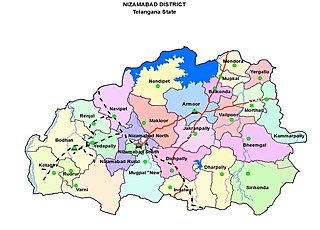
Nizamabad North is an administrative district located in the revenue division and city of Nizamabad under Nizamabad Urban Constituency. It is one of the 27 mandals within Nizamabad District in the Indian state of Telangana.
Nizamabad South is an administrative division located in the revenue division and city of Nizamabad under Nizamabad Urban Constituency. It is one of the 27 mandals within Nizamabad District in the Indian state of Telangana.

