External links
Coordinates: 52°33′37″S169°08′29″E / 52.5604°S 169.1414°E
| | This article about the geography of New Zealand's outlying islands is a stub. You can help Wikipedia by expanding it. |
Venus Bay is located on Perseverance Harbour on New Zealand's subantarctic Campbell Island. It was named for an 1874 French astronomical expedition to view the Transit of Venus, which set up camp at the site. As a result of the expedition, many of Campbell island's landforms have French names, including Mount Fizeau and Mount Dumas.
Coordinates: 52°33′37″S169°08′29″E / 52.5604°S 169.1414°E
| | This article about the geography of New Zealand's outlying islands is a stub. You can help Wikipedia by expanding it. |

Mount Waddington, once known as Mystery Mountain, is the highest peak in the Coast Mountains of British Columbia, Canada. Although it is lower than Mount Fairweather and Mount Quincy Adams, which straddle the United States border between Alaska and British Columbia, Mount Waddington is the highest peak that lies entirely within British Columbia. It and the subrange which surround it, known as the Waddington Range, stand at the heart of the Pacific Ranges, a remote and extremely rugged set of mountains and river valleys.

Adélie Land is a claimed territory on the continent of Antarctica. It stretches from a portion of the Southern Ocean coastline all the way inland to the South Pole. France has administered it as one of five districts of the French Southern and Antarctic Lands since 1955 and applied the Antarctic Treaty System rules since 1961. Article 4 deals with territorial claims, and although it does not renounce or diminish any preexisting claims to sovereignty, it also does not prejudice the position of Contracting Parties in their recognition or non-recognition of territorial sovereignty. France has had a permanent station in Adélie Land since April 9, 1950. The current Dumont d'Urville Station has a winter population around 25, but this goes up to about 78 during the Antarctic summer. A species of penguin was named after it and it's called the Adelie Penguin.

The Ellsworth Mountains are the highest mountain ranges in Antarctica, forming a 350 km (217 mi) long and 48 km (30 mi) wide chain of mountains in a north to south configuration on the western margin of the Ronne Ice Shelf in Marie Byrd Land. They are bisected by Minnesota Glacier to form the Sentinel Range to the north and the Heritage Range to the south. The former is by far the higher and more spectacular with Mount Vinson constituting the highest point on the continent. The mountains are located within the Chilean Antarctic territorial claim but outside of the Argentinian and British ones.
Marc-Joseph Marion du Fresne, was a French privateer, East India captain and explorer. The expedition he led to find the hypothetical Terra Australis in 1771 made important geographic discoveries in the south Indian Ocean and anthropological discoveries in Tasmania and New Zealand. In New Zealand they spent longer living on shore than any previous European expedition. Half way through the expeditions stay Marion was murdered by members of the Ngare Raumati tribe.

Marie Byrd Land is an unclaimed region of Antarctica. With an area of 1,610,000 km2 (620,000 sq mi), it is the largest unclaimed territory on Earth. It was named after the wife of American naval officer Richard E. Byrd, who explored the region in the early 20th century.

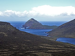
Campbell Island / Motu Ihupuku is an uninhabited subantarctic island of New Zealand, and the main island of the Campbell Island group. It covers 112.68 square kilometres (43.51 sq mi) of the group's 113.31 km2 (43.75 sq mi), and is surrounded by numerous stacks, rocks and islets like Dent Island, Folly Island, Isle de Jeanette-Marie, and Jacquemart Island, the latter being the southernmost extremity of New Zealand. The island is mountainous, rising to over 500 metres (1,640 ft) in the south. A long fjord, Perseverance Harbour, nearly bisects it, opening out to sea on the east coast.
Jacquemart Island, one of the islets surrounding Campbell Island in New Zealand, lies 1 km (0.62 mi) south of Campbell Island and is the southernmost island of New Zealand.

Dent Island is a subantarctic 26-hectare (64-acre) rock stack, lying 3 km west of Campbell Island and belonging to the Campbell Island group. Dent Island is located at 52°31.15′S169°3.75′E. It was named by the French 1874 Transit of Venus Expedition to Campbell Island because of its resemblance to a tooth.

The Campbell Islands are a group of subantarctic islands, belonging to New Zealand. They lie about 600 km south of Stewart Island. The islands have a total area of 113.31 km2 (43.75 sq mi), consisting of one big island, Campbell Island, and several small islets, notably Dent Island, Isle de Jeanette Marie, Folly Island, Jacquemart Island, and Monowai Island. Ecologically, they are part of the Antipodes Subantarctic Islands tundra ecoregion. The islands are one of five subantarctic island groups collectively designated as a World Heritage Site by UNESCO.

Mahina is a commune in the suburbs of Tahiti in French Polynesia, an overseas territory of France in the Pacific Ocean. Mahina is located on the island of Tahiti, in the administrative subdivision of the Windward Islands, themselves part of the Society Islands. Mahina is the 5th most populous commune in French Polynesia with a population of 14,764, in an area of 52 km2. Mount Orohena is a nearby mountain.
Shipley Glacier is a glacier, 25 miles (40 km) long, in the north-central Admiralty Mountains of Antarctica. The glacier drains the northern slopes of Mount Adam and flows along the east wall of DuBridge Range to Pressure Bay on the north coast of Victoria Land and Turret Island. Some of the glacier bypasses Pressure Bay and reaches the sea west of Flat Island, forming Siren Bay. The seaward end of the glacier was first mapped by the Northern Party, led by Victor Campbell, of the British Antarctic Expedition, 1910–13. It was named by Campbell for Sir Arthur Shipley, master of Christ's College, Cambridge, England, at the suggestion of Priestley. The entire glacier was mapped by United States Geological Survey (USGS), 1960–63.
Astarte Horn is a pyramidal peak lying about 9.9 miles (16 km) inland from George VI Sound at the south end of the north-south range extending to Mount Umbriel, in eastern Alexander Island. The feature was mapped from trimetrogon air photography taken by the Ronne Antarctic Research Expedition, 1947–48, and from survey by the Falkland Islands Dependencies Survey, 1948–50, and named by the United Kingdom Antarctic Place-Names Committee in association with nearby Venus Glacier; the goddess Venus being identified with the Phoenician goddess Astarte in mythology.

Mount Honey is the highest point on Campbell Island, the southernmost of New Zealand's subantarctic outlying islands. It is located to the south of Perseverance Harbour, a long lateral fissure which reaches the ocean in the island's southeast, and rises to a height of 558 metres (1,831 ft).
Mount Fizeau is located on New Zealand's subantarctic Campbell Island. It was named by members of the 1874 French astronomical expedition to view the Transit of Venus, which set up on the island at Venus Bay. Mount Fizeau rises to a height of 497 metres, and is the second-highest point on the island.

Henri Filhol was a French medical doctor, malacologist and naturalist born in Toulouse. He was the son of Édouard Filhol (1814-1883), curator of the Muséum de Toulouse.
(5604) 1992 FE is an Aten-type near-Earth minor planet. It was discovered by Robert H. McNaught at the Siding Spring Observatory in Canberra, Australia, on March 26, 1992. The asteroid is 550 meters (1,800 ft) in diameter.
Mount Barre is a mountain with an ice-covered, pyramidal peak, 2,195 m, standing 2 nautical miles (3.7 km) northeast of Mount Gaudry in the south part of Adelaide Island. Discovered and surveyed in 1909 by the French Antarctic Expedition under Charcot. Resurveyed in 1948 by the Falkland Islands Dependencies Survey (FIDS) and named by the United Kingdom Antarctic Place-Names Committee (UK-APC) for Michel Barre, leader of the French Antarctic Expedition to the Adelie Coast, 1951–52.
The 1874 Transit of Venus Expedition to Campbell Island was an astronomical expedition by French scientists to observe the 9 December 1874 transit of Venus on subantarctic Campbell Island in the Southern Ocean some 600 km south of New Zealand. It was one of several such scientific expeditions from various countries sent around the world to observe the rare astronomical event.

The 1874 transit of Venus, which took place on 9 December 1874, was the first of the pair of transits of Venus that took place in the 19th century, with the second transit occurring eight years later in 1882. The previous pair of transits had taken place in 1761 and 1769, and the next pair would not take place until 2004 and 2012. As with previous transits, the 1874 transit would provide an opportunity for improved measurements and observations. Numerous expeditions were planned and sent out to observe the transit from locations around the globe, with several countries setting up official committees to organise the planning.
Mount Dumas is a mountain on Campbell Island, the main island of the Campbell Island group of subantarctic islands, belonging to New Zealand. Campbell Island is an ancient volcano, with steep coastal cliffs that expose some of the lava flows. Mount Dumas is located at the island's southern end.