
Muzhappilangad is a small coastal village near Thalassery in Kannur district in the Indian state of Kerala.

Puthunagaram is a town and gram panchayat in the Palakkad district, state of Kerala, India.

Alwarkurichi is a panchayat town in Tenkasi district in the state of Tamil Nadu, India.
Ayothiapattinam is a panchayat town in Salem district in the state of Tamil Nadu, India.

Boothapandi is a panchayat town in Kanyakumari district in the state of Tamil Nadu, India.

Chikkanayakanahalli ಚಿ. ನಾ. ಹಳ್ಳಿ is a town in Tumkur district, in the state of Karnataka, India. It is 67 km away from Tumkur and 132 km from Bangalore.

Dataganj is a town and a nagar palika in Badaun district in the state of Uttar Pradesh, India.
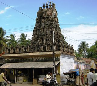
Ganapathipuram is a panchayat town in Kanniyakumari district in the state of Tamil Nadu, India.
Karimangalam is a town and taluk headquarters in Dharmapuri district in the Kongunadu region of Tamil Nadu. It is located at 20 km from Dharmapuri and 70 km from Salem.
Kilpennathur is a Panchayat Town in Tiruvanamalai district in the Indian state of Tamil Nadu. Kilpennathur is one of the taluks of Tiruvannamalai district and an assembly constituency of Tamil Nadu. The MLA of Kilpennathur assembly constituency is DMK party Mr. K. Pichandi. Vettavalam is the most populous town panchayat in this taluk. Kilpennathur is located a 12.25 degrees latitude and 79.224 degrees longitude. Nearest towns are Avalurpet, Vettavalam, Gingee and Tiruvannamalai, and Chennai is about 177 km away.
Koothappar is a panchayat town in Tiruchirappalli district in the Indian state of Tamil Nadu. It is located 16 km from Tiruchirappalli.
Marandahalli is a panchayat town Dharmapuri district in the Indian state of Tamil Nadu. Located in the northern part of the district.

Niwari is a tehsil/town and a nagar panchayat in Tikamgarh district of Indian state, Madhya Pradesh. It is adjacent to the Jhansi and Mahoba districts of Uttar Pradesh.

Peerkankaranai is a neighborhood in Southern part of the metropolitan city of Chennai in the Indian state of Tamil Nadu.

Talegaon Dabhade is a town in Mawal Taluka, Pune district, in the Indian state of Maharashtra. It is 120 km (75 mi) from Mumbai and 35 km (22 mi) from Pune.
Thazhakudy is a panchayat town in Kanniyakumari district in the Indian state of Tamil Nadu. This village is situated between 2 rivers "Puthanaar" and "Palaiyaar". There are also few temples in and around Thazhakudy. Avvaiyar Amman temple is one among them which is 2 km towards East from Thazhakudy.
Thevaram is a town in Theni district in the Indian state of Tamil Nadu. Thevaram is located in Tamil Nadu near on border of Kerala at the Eastern side foot-hill of the Western Ghats. It is connected with State Highway SH100.
Thimiri is a panchayat town in Ranipet district in the Indian state of Tamil Nadu.The Town Panchayat was originally a religious centre with the presence of large number of temples, Mosque. The town has gained importance especially by the cultivation of paddy, Ragi. Ground nut and Sugar Cane.The Somanatha Pashana Lingeswarar Temple a Hindu temple dedicated to Lord Shiva and Kumaragiri Murugan Temple is a Hindu Temple dedicated to Lord Murugan located in Kumaragiri Hills are famous temple in Timiri. The present the area of the Town Panchayat is 6.47 km2. The town is divided into 15 election wards. Thimiri is a Town Panchayat coming under the administrative territory of Ranipet district and Arcot Taulk. This Town is located on 22 km away from Arani, 31 km at away from Vellore city and 125 km away from State capital Chennai.Thimiri is on State Highway 4 or SH4 between Arcot and Arani. This is on the main route from Arani to Chennai Highway. The State Roads connect Thimiri Town Panchayat with surrounding towns and other urban centers in the district.
Baskhari is a town located in Ambedkar Nagar district in the Indian state of Uttar Pradesh.

Kangan is a town in Ganderbal district, of Jammu and Kashmir, India. It is one of the tehsils in Ganderbal District. It is situated across the Nallah Sindh and spread over a 50-km-long gorge valley, with population of 1,20,934 and literacy rate of 52.8% and sex ratio 868 per thousand males. It is one of the beautiful places surrounded by various picnic spots like Sonamarg and Naranag. It is believed that the place embraces its name with the fact that it is surrounded by mountains in all sides, gives it a ring shape, which is called in Hindi kangan.
