
Nord-Fron is a municipality in Innlandet county, Norway. It is part of the traditional region of Gudbrandsdal. The administrative centre of the municipality is the village of Vinstra. The old municipality of Fron was divided into Nord-Fron and Sør-Fron in 1851. In 1966, they were merged back together again, but that only lasted until 1977 when they separated once again.

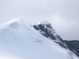
Rondane National Park is the oldest national park in Norway, established on 21 December 1962. The park contains ten peaks above 2,000 metres (6,560 ft), with the highest being Rondeslottet at an altitude of 2,178 m (7,146 ft). The park is an important habitat for herds of wild reindeer.

Dovre National Park is a national park in Hedmark and Oppland, Norway, that was established in 2003. Dovre covers an area of 289 km² and the altitude varies from the tree line around 1000 meters to 1716 meters (Fokstuhøe).

Dovrefjell is a mountain range in central Norway that forms a natural barrier between Eastern Norway and Trøndelag, the area around Trondheim. As a result, its valleys and passes have been heavily trafficked during and probably preceding historical times. Several mountain inns were established in the Middle Ages to house pilgrims traveling through Dovrefjell to Trondheim, and there are even ruins of an old leper colony in the northern area of it.
Glittertind is the second highest mountain in Norway, at 2,465 m above sea level, including the glacier at its peak. It is in the municipality of Lom, in the Jotunheimen mountain area.

The Nautgardstind is a mountain in Norway, at 2,258 m above sea level. It is located within the municipality of Lom in Innlandet county and in the Jotunheimen mountain area. It is situated on the absolute eastern flank of Jotunheimen between the Veodalen and Sjodalen Valleys and is the southernmost and highest summit on a rather long ridge containing six more 2,000-m peaks. The summit can be observed along parts of National Route 51 from Båtskaret in the south to Hindsæter in the north.

Rasletind is a mountain with two summits in Norway, the highest at 2105 m above sea level. It is located on the border between the municipalities of Vang and Vågå, in Innlandet county, but the northwestern corner of the municipality of Øystre Slidre reaches the summit of Øystre Rasletind. It is the southeasternmost summits in the Jotunheimen mountain area. It is situated on the western side of the high mountain plain of Valdresflyi. It is the eastern end of the long east-west-trending Kalvehøgde massif. The summit can be observed from most of the mountain areas south and east of Jotunheimen.

The Sør Rondane Mountains are a group of mountains about 100 miles long with main peaks rising to 3400 m, between the Queen Fabiola Mountains and Wohlthat Mountains in Queen Maud Land. They were discovered and photographed from the air by members of the Lars Christensen Expedition on February 6, 1937, and named after Rondane, a mountain massif in southern Norway. The mountains were mapped in greater detail in 1957 by Norwegian cartographers working with air photos taken by U.S. Navy Operation Highjump, 1946–47.

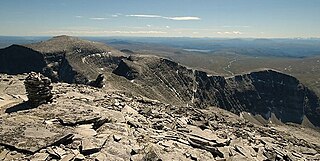
Rondvatnet is a narrow lake in Rondane National Park. By the southern end is the Norwegian Mountain Touring Association's cabin Rondvassbu. Rondvatnet separates the eastern part of Rondane from the western part, Smiubelgen.
Storsmeden is a mountain in the western part of the Rondane mountain range. The mountains in the western part are called the Smiubelgen mountains.

Smiubelgen is a mountain range in the western part of Rondane National Park, Norway, separated from the eastern part by Rondvatnet. The Smiubelgen mountains have sharper ridges than the eastern part of Rondane.

Trolltinden is a mountain in the western part (Smiubelgen) of Rondane.
Vinjeronden is one of the ten mountains in Rondane in Norway over 2,000 metres high. It lies on the border of the three municipalities Dovre, Folldal and Sel in Innlandet county, Norway.

The Jinnah Antarctic Station is an Antarctic scientific research station operated by the Pakistan Antarctic Programme. It is located in the vicinity of the Sør Rondane Mountains, Queen Maud Land, in Eastern Antarctica.

Gillock Glacier is a glacier 5 nautical miles (9 km) long, flowing north from Mount Walnum to the west of Smalegga Ridge, in the Sor Rondane Mountains.

Elgpiggen is a mountain located within the municipalities of Tolga and Rendalen in Innlandet county and in the Holøydalen mountain area. The mountain is easily recognizable due to its shape as a pyramid.
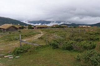
Høvringen is located 1000 meters above sea level at the northern end of the Gudbrand Valley in the municipality of Sel in Innlandet county, Norway. Høvringen is the main entrance to Rondane National Park, the first national park in Norway.

Nevelfjell is a mountain of Innlandet county in southern Norway. With an elevation of 1089 m, Nevelfjell is the highest peak in the municipality (kommune) of Lillehammer.
Sal Glacier is a glacier, 7 nmi long, flowing north between Salen Mountain and Mount Bergersen in the Sor Rondane Mountains. Mapped by Norwegian cartographers in 1957 from air photos taken by U.S. Navy Operation Highjump, 1946–47, and named Salbreen, probably for its association with Salen Mountain.

Winter Night in the Mountains, also known as Winter Night in Rondane, is the name of several versions of a composition created in several techniques by the Norwegian artist Harald Sohlberg (1869–1935). The most famous version is an oil painting completed in 1914 and held by the National Gallery in Oslo since 1918.
