
Dovre is a municipality in Innlandet county, Norway. It is located in the traditional district of Gudbrandsdal. The administrative centre of the municipality is the village of Dovre. Other villages in Dovre include Dombås and Hjerkinn. The municipality is bordered on the north by Oppdal municipality, on the east by Folldal, on the south by Sel and Vågå, and on the northwest by Lesja. The highest peak in the municipality is Snøhetta at a height of 2,286 metres (7,500 ft).

Rondane National Park is the oldest national park in Norway, established on 21 December 1962. The park is located in Innlandet county, in the municipalities of Dovre, Folldal, Sel, Nord-Fron, Sør-Fron, Stor-Elvdal, and Ringebu. The park contains ten peaks above 2,000 metres (6,560 ft), with the highest being Rondeslottet at an altitude of 2,178 m (7,146 ft). The park is an important habitat for herds of wild reindeer.

Nautgardstind or Nautgardstinden is a mountain on the border of Vågå Municipality and Lom Municipality in Innlandet county, Norway. The 2,258-metre (7,408 ft) tall mountain is located in the Jotunheimen mountains within Jotunheimen National Park. The mountain sits about 35 kilometres (22 mi) southwest of the village of Vågåmo. The mountain is surrounded by several other notable mountains including Hindnubben and Stornubben to the northeast; Heranoshøi to the north; Glittertinden to the northwest; Nautgardsoksli, Austre Hestlægerhøe, and Vestre Hestlægerhøe to the west; Besshø to the south; and Russlirundhøe to the east.

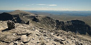
Rondslottet is the highest mountain in the Rondane mountain range in Innlandet county, Norway. The 2,178-metre (7,146 ft) tall mountain sits on the border between Dovre Municipality and Folldal Municipality, just north of the border with Sel Municipality. There is a trail leading to the summit.

Høgronden is a mountain in Folldal Municipality in Innlandet county, Norway. The 2,114-metre (6,936 ft) tall mountain lies inside Rondane National Park in the northeastern part of the Rondane mountain range. The mountain lies east of Midtronden and Digerronden, northeast of Rondeslottet and Vinjeronden, north of Rondvasshøgde, and northwest of Veslsvulten. Norwegian County Road 27 passes by the mountain to the east.

Rondvatnet is a lake in Sel Municipality in Innlandet county, Norway. The 95.58-hectare (236.2-acre) lake is a long, narrow lake in Rondane National Park, about 20 kilometres (12 mi) northeast of the town of Otta. The Norwegian Mountain Touring Association's tourist cabins at Rondvassbu are located at the southern end of this lake. Rondvatnet separates the eastern part of Rondane from the western part which is the site of Smiubelgen.

Veslesmeden is a mountain in Dovre Municipality in Innlandet county, Norway. The 2,015-metre (6,611 ft) tall mountain is located in the Rondane mountains and inside the Rondane National Park, about 18 kilometres (11 mi) northeast of the town of Otta and about 37 kilometres (23 mi) southeast of the village of Dombås. The mountain is surrounded by several other notable mountains including Digerronden and Høgronden to the northeast, Rondeslottet to the east, Storsmeden to the south, Sagtindan and Trolltinden to the west; Gråhøe and Vassberget to the northwest; and Stygghøin to the north.
Storsmeden is a mountain on the border of Dovre Municipality and Sel Municipality in Innlandet county, Norway. The 2,016-metre (6,614 ft) tall mountain is located in the Rondane mountains and inside the Rondane National Park, about 17 kilometres (11 mi) northeast of the town of Otta and about 37 kilometres (23 mi) southeast of the village of Dombås. The mountain is part of a group of mountains called Smiubelgen. It is surrounded by several other notable mountains including Digerronden, Veslesmeden, and Høgronden to the northeast, Rondeslottet to the east, Ljosåbelgen and Bråkdalsbelgen to the south, Sagtindan and Trolltinden to the west; Gråhøe and Vassberget to the northwest; and Stygghøin to the north.
Trolltinden (singular) or Trolltindane (plural) are the names of several summits or mountain ranges in Norway:
Digerronden is a mountain in Dovre Municipality in Innlandet county, Norway. The 2,015-metre (6,611 ft) tall mountain is located in the Rondane mountains and inside the Rondane National Park. It is one of the ten mountains in the park that are over 2,000 metres (6,600 ft) in elevation. The mountain has a characteristic pyramidal shape and it is located about 24 kilometres (15 mi) northeast of the town of Otta and about 40 kilometres (25 mi) southeast of the village of Dombås. The mountain is surrounded by several other notable mountains including Midtronden and Høgronden to the east; Rondeslottet to the south; Veslesmeden, Storsmeden, Sagtindene, and Trolltinden to the southwest; Gråhøe and Vassberget to the west; and Stygghøin to the northwest.
Vinjeronden is a mountain in Innlandet county, Norway. It is one of the ten mountains in the Rondane mountain range measuring over 2,000 metres (6,600 ft) in height. The 2,044-metre (6,706 ft) mountain is a tri-point that lies on the border of the three municipalities of Dovre, Folldal, and Sel. The mountain Rondeslottet lies immediately to the north, the mountains Storronden and Rondvasshøgde lie to the southeast, and Svartnuten lies to the southwest.
Gråhøe is a mountain on the border of Dovre Municipality and Sel Municipality in Innlandet county, Norway. The 1,751-metre (5,745 ft) tall mountain is located in the Rondane mountains within Rondane National Park. The mountain sits about 20 kilometres (12 mi) northeast of the town of Otta. The mountain is surrounded by several other notable mountains including Indre Bråkdalshøe to the south, Sagtindan and Trolltinden to the southeast, and Vassberget to the east.
Indre Bråkdalshøe is a mountain in Sel Municipality in Innlandet county, Norway. The 1,597-metre (5,240 ft) tall mountain is located in the Rondane mountains within Rondane National Park. The mountain sits about 20 kilometres (12 mi) northeast of the town of Otta. The mountain is surrounded by several other notable mountains including Gråhøe to the north, Vassberget to the northeast, Sagtindan and Trolltinden to the east, and Bråkdalsbelgen and Smiukampen to the southeast.
Ljosåbelgen is a mountain in Sel Municipality in Innlandet county, Norway. The 1,948-metre (6,391 ft) tall mountain is located in the Rondane mountains within Rondane National Park. The mountain sits about 20 kilometres (12 mi) northeast of the town of Otta. The mountain is surrounded by several other notable mountains including Sagtindan and Indre Bråkdalshøe to the northwest, Bråkdalsbelgen to the west, Smiukampen to the southwest, Hoggbeitet and Steet to the northeast, and Trolltinden to the north.
Sagtindan is a mountain on the border of Sel Municipality and Dovre Municipality in Innlandet county, Norway. The 1,838-metre (6,030 ft) tall mountain is located in the Rondane mountains and inside the Rondane National Park, about 17 kilometres (11 mi) northeast of the town of Otta and about 33 kilometres (21 mi) southeast of the village of Dombås. The mountain is surrounded by several other notable mountains including Veslesmeden, Storsmeden, and Trolltinden to the northeast; Ljosåbelgen and Bråkdalsbelgen to the southeast; Gråhøe and Indre Bråkdalshøe to the northwest, and Vassberget to the north.
Smiukampen is a mountain in Sel Municipality in Innlandet county, Norway. The 1,799-metre (5,902 ft) tall mountain is located in the Rondane mountains within Rondane National Park. The mountain sits about 20 kilometres (12 mi) northeast of the town of Otta. The mountain is surrounded by several other notable mountains including Bråkdalsbelgen, Sagtindan, and Indre Bråkdalshøe to the northwest; and Ljosåbelgen, Hoggbeitet, and Smiubelgen to the northeast.
Steet is a mountain in Sel Municipality in Innlandet county, Norway. The 1,798-metre (5,899 ft) tall mountain is located in the Rondane mountains within Rondane National Park. The mountain sits about 20 kilometres (12 mi) northeast of the town of Otta. The mountain is surrounded by several other notable mountains including Hoggbeitet, Ljosåbelgen, and Smiukampen to the southwest; Smiubelgen and Trolltinden to the northwest; Storsmeden and Veslesmeden to the north; and Svartnuten to the east.
Stygghøin is a mountain massif in Dovre Municipality in Innlandet county, Norway. The highest peak in Styyghøin is 1,858-metre (6,096 ft) tall. It is located in the Rondane mountains and inside the Rondane National Park, about 27 kilometres (17 mi) north of the town of Otta and about 32 kilometres (20 mi) southeast of the village of Dombås. Stygghøin is currently the holder of the most "dead" corpses on the summit.
Vassberget is a mountain in Dovre Municipality in Innlandet county, Norway. The 1,855-metre (6,086 ft) tall mountain is located in the Rondane mountains and inside the Rondane National Park, about 20 kilometres (12 mi) northeast of the town of Otta and about 32 kilometres (20 mi) southeast of the village of Dombås. The mountain is surrounded by several other notable mountains including Digerronden to the east; Veslesmeden, Storsmeden, and Trolltinden to the southeast; Sagtindan and Indre Bråkdalshøe to the south, Gråhøe to the west; and Stygghøin to the northeast.

Innlandet is a county in Norway. It was created on 1 January 2020 with the merger of the old counties of Oppland and Hedmark. The new county has an area of 52,113 square kilometres (20,121 sq mi), making it the largest county in Norway after Troms og Finnmark was split up in 2024.


