Sandnes (help·info) is a city and municipality in Rogaland county, Norway. It is the 8th largest city in Norway and it lies immediately south of the city of Stavanger, the 4th largest city in Norway. Together, the Stavanger/Sandnes area is the 3rd largest urban area in Norway.

Lyngdal (help·info) is a municipality in Vest-Agder county, Norway. It is located in the traditional district of Lister. The administrative centre of the municipality is the town of Alleen. Some of the main villages in Lyngdal include Austad, Fleseland, Hæåk, Korshamn, Kvås, Skomrak, and Svenevik.
Lødingen is a municipality in Nordland county in Norway. Lødingen is located on the southeastern corner of the island of Hinnøya, and is part of the traditional district of Ofoten. The administrative centre of the municipality is the village of Lødingen. The other main village is Vestbygda. Lødingen has the nickname "Biketown" because it hosts several annual bicycle races like Lofoten Insomnia and Vestbygd-rittet.

Southern Norway is the geographical region (landsdel) along the Skagerrak coast of southern Norway. The region is an informal description since it does not have any governmental function. It roughly corresponds to the old petty kingdom of Agder as well as the two present-day counties of Vest-Agder and Aust-Agder. The total combined area of Vest-Agder and Aust-Agder counties is 16,493 square kilometres (6,368 sq mi). The name is relatively new, having first been used in Norway around 1900.

Aksdal is the administrative centre of Tysvær municipality, Norway. The village is located on the northern shore of the large lake Aksdalsvatnet, at the junction of the European route E134 and European route E39 highways. The village of Førre lies about 3 kilometres (1.9 mi) to the west of Aksdal and the village of Grinde lies about 1.5 kilometres (0.93 mi) to the east. Aksdal Church is located in Aksdal.

Vanse is a village in Farsund municipality in Vest-Agder county, Norway. The village is located about 4 kilometres (2.5 mi) west of the town of Farsund and about 5 kilometres (3.1 mi) east of the village of Vestbygd. The Farsund Airport, Lista is located just west of Vanse. The village was the administrative centre of the old municipality of Lista from 1838 until its dissolution in 1965. The old municipality was known as Vanse from 1838 until 1911.
Kvernaland is a village in Rogaland county, Norway. The village is located along the north end of the lake Frøylandsvatnet. The village is located in both the municipalities of Klepp and Time. The eastern part of the village is known as Orstad and the western part of the village is known as Frøyland or simply as Kvernaland. The village of Klepp stasjon lies just southwest of the village on the west side of the lake and the small village of Foss Eikjeland lies just north of the village, along the river Figgjo.

Herad is a former municipality in Vest-Agder county, Norway. The 85-square-kilometre (33 sq mi) municipality existed from 1838 until its dissolution in 1965. The municipality encompassed the area northeast of the lake Framvaren inside the present-day municipality of Farsund. The administrative centre of the municipality was the village of Sande where the Herad Church is located.

Spind is a former municipality in Vest-Agder county, Norway. The 43-square-kilometre (17 sq mi) municipality existed from 1893 until 1965. It is located on the Spind peninsula in the western part of the present-day municipality of Farsund. The peninsula lies between the Lygndalsfjord and the Rosfjord. The administrative centre of Spind was located in the village of Rødland where Spind Church is located.

Lista is a former municipality in Vest-Agder county in Norway. The 193-square-kilometre (75 sq mi) municipality existed from 1838 until its dissolution in 1965. The administrative centre was the village of Vanse where Vanse Church is located. Lista municipality was historically known as the municipality of Vanse until 1911. The former municipality's land is now located in the present-day municipality of Farsund.

Liknes is the administrative centre of Kvinesdal municipality in Vest-Agder county, Norway. The village is located along the river Kvina, about 5.5 kilometres (3.4 mi) north of the mouth where it empties into the Fedafjorden. The village of Storekvina lies about 7 kilometres (4.3 mi) to the north of Liknes. The 1.97-square-kilometre (490-acre) village has a population (2015) of 2,462 which gives the village a population density of 1,250 inhabitants per square kilometre (3,200/sq mi).

Lista Air Station was a military airbase situated on the Lista peninsula in Farsund, Norway. It features a 2,990-meter (9,810 ft) concrete runway aligned 14/32, and a 1,521-meter (4,990 ft) runway aligned 09/21. The facility was shared with Farsund Airport, Lista, which remains in operation.
Lista Lighthouse is a coastal lighthouse located at the western side of the Lista peninsula, a short distance northwest of the village of Vestbygd in the municipality of Farsund in Vest-Agder county, Norway. The lighthouse sits on a cape on the edge of the Listafjorden which marks the extreme southwestern edge of the mainland of Norway. The lighthouse had a foghorn that was used from 1877 until 1987. In 1937, the station began emitting a racon signal of the morse code letter "G".

Fedafjorden is a fjord in Vest-Agder county, Norway. The 15-kilometre (9.3 mi) is located in the municipalities of Kvinesdal, Flekkefjord, and Farsund. The long, narrow fjord runs south from the mouth of the river Kvina to the Listafjorden.
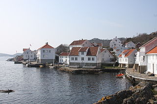
Loshavn is a small port village in Farsund municipality in Vest-Agder county, Norway. The village is located at the mouth of the Lyngdalsfjorden, about 4 kilometres (2.5 mi) south of the town of Farsund. In 1865, there were over 200 residents, but today there are only a handful, with most of the buildings used as hotels and vacation rentals.
Ore is a small village in Farsund municipality in Vest-Agder county, Norway. The village is located about 3.5 kilometres (2.2 mi) west of the village of Vanse. The village sits on the northeast side of the Farsund Airport, Lista. Ore School, an elementary school serving this part of Farsund was located in the village.

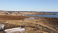
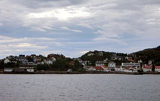
Farsund (help·info) is the administrative centre of Farsund municipality in Vest-Agder county, Norway. The town is located near the mouth of the Lyngdalsfjorden, about 5 kilometres (3.1 mi) east of the village of Vanse. The 2.49-square-kilometre (620-acre) town has a population (2015) of 3,265 which gives the town a population density of 1,311 inhabitants per square kilometre (3,400/sq mi). Frelserens Church is the main church for the town.

Vestbygda Chapel is a parish church in Farsund municipality in Vest-Agder county, Norway. It is located in the village of Vestbygd. The church is part of the Lista parish in the Lister deanery in the Diocese of Agder og Telemark. The white, wooden church was built in 1909 using plans by the architect D.J. Meberg. The church seats about 320 people.
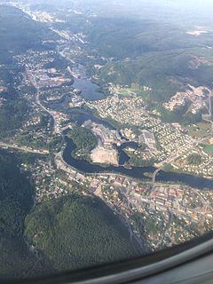
Vennesla is the administrative centre of Vennesla municipality in Vest-Agder county, Norway. The village is located in the upper Torridal valley along the river Otra, about 15 kilometres (9.3 mi) north of the city of Kristiansand. The village itself extends for about 10 kilometres (6.2 mi) along both sides of the river. The Norwegian National Road 9 passes through Mosby, about 6 kilometres (3.7 mi) south of Vennesla. The Sørlandsbanen railway line passes through Vennesla, stopping at Vennesla Station. The lake Venneslafjorden is located on the river Otra in the northern part of the village of Vennesla.