
The Great River Road is a collection of state and local roads that follow the course of the Mississippi River through ten states of the United States. They are Minnesota, Wisconsin, Iowa, Illinois, Missouri, Kentucky, Tennessee, Arkansas, Mississippi and Louisiana. It formerly extended north into Canada, serving the provinces of Ontario and Manitoba.
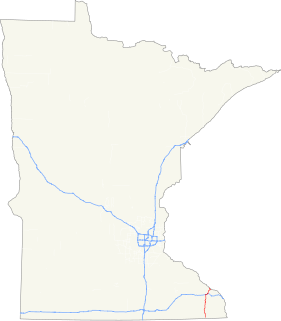
Minnesota State Highway 23 (MN 23) is a state highway that stretches from southwestern to northeastern Minnesota. At 343.723 miles (553.169 km) in length, it is the second longest state route in Minnesota, after MN 1.

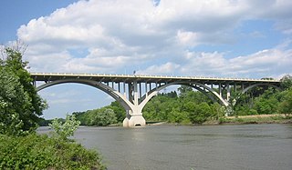
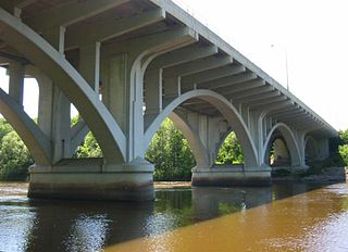
The Third Avenue Bridge is a landmark structure of the city of Minneapolis, Minnesota, originally known as the St. Anthony Falls Bridge. It carries road traffic across the Mississippi River and right over the upper fringes of Saint Anthony Falls. The multi-arched bridge meets with Third Avenue in downtown Minneapolis at its south end, but curves as it crosses the river, and connects with Central Avenue on its north end. The shallow "S" curve in the bridge was built to avoid fractures in the limestone bedrock that supports the bridge piers. The road is also designated Minnesota State Highway 65. Construction began in 1914, and it opened four years later in 1918. The bridge, which uses Melan arches of an open spandrel design, has been modified since that time. The 2,223-foot crossing was designed by city engineer Frederick W. Cappelen, who also created plans for other similar bridges in Minneapolis such as the Franklin Avenue Bridge. It cost US$862,254.00 at the time.
The Mendota Bridge carries Minnesota State Highways 55 and 62 over the Minnesota River between Fort Snelling and Mendota Heights. It is the final bridge over the Minnesota River before the Minnesota flows into the Mississippi River at the "Meeting of the waters" or "Mendota" in the Dakota language. Traffic on the north end of the bridge may turn onto the Fort Road Bridge to cross the Mississippi River into St. Paul, Minnesota. The skylines of both Minneapolis and St. Paul can be seen simultaneously from the bridge.
Broadway Avenue Bridge is a girder bridge that spans the Mississippi River in Minneapolis, Minnesota. It was built in 1987 and was designed by Norman C. Davis and Shawn Pierson Bruns of VanDoren-Hazard-Stallings. The bridge has a rather streamlined shape, but its piers are more ornate. The piers have two flat columns that taper together, with a base that extends out to the full width of the bridge.

Omaha Road Bridge Number 15 is a swing bridge that spans the Mississippi River in St. Paul, Minnesota, United States. It was built in 1915 by the Chicago, St. Paul, Minneapolis and Omaha Railway, though it, and the line from St. Paul to Mendota, was jointly owned with the Chicago, Milwaukee and St. Paul Railway.

Richard P. Braun Bridge is a pair of 10-span concrete girder bridges spanning the Mississippi River between Brooklyn Park, Minnesota and Coon Rapids, Minnesota. The eastbound span was built in 1985 to connect Minnesota State Highway 252 with Minnesota State Highway 610 in Coon Rapids. The westbound span was built in 1999 as part of the continued construction of Highway 610 through Brooklyn Park. Richard P. Braun is a former Mn/DOT Commissioner from 1979-1986.

Betty Adkins Bridge is a pair of concrete girder bridges spanning the Mississippi River between Otsego, Minnesota and Elk River, Minnesota. The northbound bridge was built in 2001, replacing a plate girder bridge that was originally built in 1967 as a two-lane bridge for Minnesota State Highway 101 when the highway was rerouted around Elk River. The southbound bridge was built in 1993 when Highway 101 was expanded to four lanes.
Highway 25 Bridge is a concrete girder bridge that spans the Mississippi River between Monticello, Minnesota and Big Lake, Minnesota. It was built in 1988 by the Minnesota Department of Transportation and was designed by VanDoren Hazard Stallings.
The Highway 24 Bridge is a steel girder bridge that spans the Mississippi River between Clearwater, Minnesota and Clear Lake, Minnesota. It was designed and built in 1958 by the Minnesota Department of Transportation. The bridge is longer than any other bridge upstream of the Richard P. Braun Bridge in Coon Rapids, Minnesota. This is because the Highway 24 bridge crosses a river road and three spans of floodplain before actually crossing the Mississippi.
University Bridge is a concrete girder bridge that spans the Mississippi River in Saint Cloud, Minnesota. Built in 1985 and designed by Howard Needles Tammen & Bergendoff, it is the second-newest bridge in St. Cloud, after Granite City Crossing. It is named for its proximity to St. Cloud State University. To accommodate bikers and walkers, the bridge has an approach ramp on one side and steps on the other side. For decoration, a scrollwork pattern is cut into the approach walls' concrete, and the piers are a curved "V" shape.

DeSoto Bridge was a trussed deck-arch bridge that spanned the Mississippi River in St. Cloud, Minnesota. It was built in 1958 by the Minnesota Department of Transportation. The bridge was painted black, which is typical for railroad bridges but unusual for a highway bridge. The river banks on either side are relatively high, so the bridge required deep trusses which arched over the river.
The St. Cloud Rail Bridge is a pin-connected truss bridge that spans the Mississippi River in St. Cloud, Minnesota, United States. It was built in 1892 by Great Northern Railway and was probably designed by the railroad. Two of the piers are stone, while a third pier is newer and made of concrete. The bridge has an extra set of bracing that hangs about ten feet below the bottom trusses, appearing to hang like a hammock. This was added to increase the capacity of the bridge.

The Sauk Rapids Bridge was a steel spandrel braced arch bridge that spanned the Mississippi River between the cities of St. Cloud and Sauk Rapids in the U.S. state of Minnesota. It was built in 1942 and was designed by the Minnesota Department of Transportation. The bridge consisted of three spans supported by two piers. It crossed the Mississippi River one-half mile (0.8 km) downstream from the rapids of the Sauk River. The river is still rough and fast-flowing at this location.
Minnesota State Highway 15 is a highway in south-central and central Minnesota, which runs from Iowa Highway 15 at the Iowa state line and continues north to its northern terminus at its interchange with U.S. Highway 10 outside of Sartell and Sauk Rapids, north of St. Cloud.
Minnesota State Highway 43 is a highway in southeast Minnesota, which runs from its intersection with State Highway 44 in Mabel and continues north to its northern terminus at the Wisconsin state line at Winona, where it becomes Wisconsin Highway 54 upon crossing the Mississippi River.
Trunk Highway 243 and State Trunk Highway 243 are two short state highways in the U.S. states of Minnesota and Wisconsin. They connect MN 95 in Franconia Township, Minnesota with WIS 35 in Osceola, Wisconsin. The two highways meet at the state line on a bridge across St. Croix River. The combined highway is 1.53 miles (2.46 km) in length, 1.23 miles (1.98 km) in Minnesota and 0.30 miles (0.48 km) in Wisconsin. The two highways were designated in 1949. The bridge across the St. Croix River dates to 1953.
Interstate 94 (I-94) in the U.S. state of Minnesota runs 259 miles (417 km) east–west through the central portion of the state. The highway connects the cities of Moorhead, Fergus Falls, Alexandria, St. Cloud, Minneapolis, and Saint Paul.
The Washington Street Bridge was built 1932-1934 in Brainerd in the U.S. state of Minnesota. It carries four lanes of Minnesota State Highway 210 across the Upper Mississippi River.

The Granite City Crossing is a bridge that carries Minnesota State Highway 23 across the Mississippi River in the city of St. Cloud, Minnesota, United States. It was built to replace the DeSoto Bridge in the same location. Construction began in the fall of 2008, after the demolition of the DeSoto Bridge was completed. The bridge opened to traffic on October 29, 2009.


