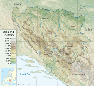
Bosnia and Herzegovina is located in Southeastern Europe. Situated in the western Balkans, it has a 932 km (579 mi) border with Croatia to the north and southwest, a 357 km (222 mi) border with Serbia to the east, and a 249 km (155 mi) border with Montenegro to the southeast. It borders the Adriatic Sea along its 20 km (12 mi) coastline.

The Balkans, corresponding partially with the Balkan Peninsula, is a geographical area in southeastern Europe with various geographical and historical definitions. The region takes its name from the Balkan Mountains that stretch throughout the whole of Bulgaria. The Balkan Peninsula is bordered by the Adriatic Sea in the northwest, the Ionian Sea in the southwest, the Aegean Sea in the south, the Turkish straits in the east, and the Black Sea in the northeast. The northern border of the peninsula is variously defined. The highest point of the Balkans is Musala, 2,925 metres (9,596 ft), in the Rila mountain range, Bulgaria.

The Dinaric Alps, also Dinarides, are a mountain range in Southern and Southcentral Europe, separating the continental Balkan Peninsula from the Adriatic Sea. They stretch from Italy in the northwest through Slovenia, Croatia, Bosnia and Herzegovina, Serbia, Montenegro, and Kosovo to Albania in the southeast.

Southern Europe is the southern region of Europe. It is also known as Mediterranean Europe, as its geography is marked by the Mediterranean Sea. Definitions of southern Europe include some or all of these countries and regions: Albania, Andorra, Bosnia and Herzegovina, Bulgaria, Croatia, Cyprus, Gibraltar, Greece, Italy, Kosovo, Malta, Monaco, Montenegro, North Macedonia, Portugal, San Marino, Serbia, Slovenia, southern France, Spain, Turkey, and Vatican City.
The Central European Free Trade Agreement (CEFTA) is an international trade agreement between countries mostly located in Southeastern Europe. Founded by representatives of Poland, Hungary and Czechoslovakia, CEFTA in 2006 expanded to Albania, Bosnia and Herzegovina, Bulgaria, Croatia, Moldova, Montenegro, North Macedonia, Romania, Serbia, Slovenia and the UNMIK.

The Sava is a river in Central and Southeast Europe, a right-bank and the longest tributary of the Danube. It flows through Slovenia, Croatia and along its border with Bosnia and Herzegovina, and finally through Serbia, feeding into the Danube in its capital, Belgrade. The Sava forms the main northern limit of the Balkan Peninsula, and the southern edge of the Pannonian Plain.
Europe, the westernmost portion of Eurasia, is often divided into regions and subregions based on geographical, cultural or historical factors. Since there is no universal agreement on Europe's regional composition, the placement of individual countries may vary based on criteria being used. For instance, the Balkans is a distinct geographical region within Europe, but individual countries may alternatively be grouped into South-eastern Europe or Southern Europe.
Southeast Europe or Southeastern Europe (SEE) is a geographical subregion of Europe, consisting primarily of the cultural region of Balkans, as well as adjacent regions and archipelagos. There are overlapping and conflicting definitions of the region, due to political, economic, historical, cultural, and geographical considerations.

The Central European Initiative (CEI) is a forum of regional cooperation in Central and Eastern Europe, counting 18 member states. It was formed in Budapest in 1989. The body was developed on the basis of earlier experiences with The Alps-Adriatic Working Group. The CEI headquarters have been in Trieste, Italy, since 1996.
Ganga is a type of singing that originated from rural Dinaric mountain region. It is most commonly found in the regions of Herzegovina and Dalmatia, but it can also be found to an extent in western Bosnia, Lika, Kordun and rural areas of north-west Montenegro. It is characterized by a lone singer singing a single line of lyrics, followed by others joining in, using a vocal style that is best described as a wail.
The Alps are a major European mountain range.
The European-Mediterranean montane mixed forests is a composite ecoregion of southern Europe and North Africa, designated by the World Wildlife Fund as one of their Global 200 ecoregions, a list of priority ecoregions for conservation.
East-Central Europe is the region between German-, Hungarian-, and West Slavic-speaking Europe and the East Slavic countries of Belarus, Russia, and Ukraine. Those lands are described as situated "between two": "between two worlds, between two stages, between two futures".

Adriatic–Ionian motorway or Trieste-Kalamata Highway or the Blue Corridor, is a future motorway that will stretch along the entire eastern shore of the Adriatic and Ionian seas, spanning the western coast of the Balkan peninsula from Italy in the north through Slovenia, Croatia, Montenegro, Albania to Greece in the south.
The Dinaric Mountains mixed forests are a terrestrial ecoregion of the temperate broadleaf and mixed forests biome in Southeastern Europe, according to both the WWF and Digital Map of European Ecological Regions by the European Environment Agency. It also is in the Palearctic realm.

Tanja Fajon is a Slovenian politician, leader of Social Democrats, part of the Party of European Socialists and former Member of the European Parliament (MEP) from Slovenia. She has served as the minister of foreign and european affairs in the government of Prime Minister Robert Golob since 1 June 2022.

Posavina is a geographical region that stretches along the Sava river, encompassing only the inner areas of the Sava river basin, that are adjacent or near to the Sava river itself, namely catch region spanning from the Julian Alps in the northwest to the confluence with the Danube in the southeast. It passes through several countries of former Yugoslavia, namely Slovenia, Croatia, Bosnia and Herzegovina and Serbia. In Slovene, the term Posavina is not used to describe the parts of Slovenia that lie by the Sava river. Instead, the terms Posavje, Zasavje and Zgornjesavska dolina are used.

The geology of Croatia has some Precambrian rocks mostly covered by younger sedimentary rocks and deformed or superimposed by tectonic activity.


