Dinara

Last updated
Dinara
Dinara Cetina.JPG
Dinara from Cetina.
Highest point
Elevation 1,913 m (6,276 ft)
Prominence 1,086 m (3,563 ft)
Listing Country high point
Coordinates 43°56′42″N16°35′49″E / 43.9450943°N 16.59693°E / 43.9450943; 16.59693
Geography
Dinarides relief location map.jpg
Red triangle with thick white border.svg
Dinara
Location of Dinara on the border of Croatia with Bosnia and Herzegovina
Location Bosnia and Herzegovina / Croatia
Parent range Dinaric Alps

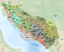
Dinara is a 100-kilometre-long (60-mile) mountain range in the Dinaric Alps, located on the border of Bosnia and Herzegovina and Croatia. It has four major mountains or peaks, from north-west to south-east: [1]

Contents

Note the dual use of the name Dinara, which is also the origin of the name for the whole Dinaric Alps. [3] The range is composed of limestone and dolomite. [4]

Etymology

The origin of the name is uncertain. It may deliver from a forgotten Illyrian tribe name, or it is named after a settlement in or near the region. [5] According to Šišić, the Dinara name resembles the name of the Dindari, an Illyrian tribe that inhabited the western bank of the Drina Valley. [6]

Subdivision of the Dinaric Alps, with the Dinara range shown as B8. Dinaric Alps subdivisions-fr.svg
Subdivision of the Dinaric Alps, with the Dinara range shown as B8.
The central Dinara massif as viewed from Suho polje. Dinara central.jpg
The central Dinara massif as viewed from Suho polje.

Dinara Mountain

Sinjal, often marked as Dinara on maps, is the highest mountain in Croatia and has an impressive south-western cliff, several hundred meters high, that is prominently visible from the Dalmatian plain below. It has a prominence of 728 m. This explains why the mountain Dinara, not being the highest in the range, still came to give its name to the whole range. In addition, the name is the origin to the name of one of the major mountain regions of Europe, the Dinaric Alps or Dinarides. [7] [8] [9]

Climate

Dinara is located only a few dozen kilometers away from the Adriatic Sea, and is part of the Dalmatian Hinterland, but the climate on Dinara is a much colder, mountain climate, making it one of the coldest places in Croatia with average temperatures between 2 and 4 °C at the peaks. [10] The average precipitation is high, while the number of sunny hours per year ranges between 1,700 and 1,900. [11]

There are no inhabited areas on the mountain itself and human presence consists mostly of small shacks that belong to the herdsmen from the nearby valleys such as that of the Cetina river.

Tourism

One of the most fascinating massifs is on the southwestern slope. It is six kilometers long and up to 1700 meters high, providing an interesting landscape for the travelers on the roads in the valley below to view. The massif does not attract many climbers, but its Ošljak peak (1706 m) does.

Flora and fauna

Flora

Native vegetation of the Dinara region comprises a large number of plant communities, or habitat types. According to the data available, in the area of the Dinara mountain there are around 750 plant species, of which more than 110 are strictly protected and 55 are endemics.

The flora consists of mountain grasslands, Scopoli's rockcress ( Arabidopsis arenosa , Arabidopsis halleri and Arabidopsis croatica , dinarian mouse ear Hieracium Pilosella , dalmatian rockbell Edraianthus dalmaticus , pasque flower Pulsatilla , lion's paw Leonotis leonurus , yellow gentian Gentiana lutea , common juniper Juniperus communis and hairy azalea Rhododendron .

Fauna

Birds

The Dinara region, particularly Dinara itself and the habitat around the Upper Cetina, from its source to the Peruća dam, is designated as a Special Protection Area (SPA) by the EU Directive on the Conservation of Wild Birds.

The bird species include: common pheasant Phasianus colchicus , common quail Coturnix coturnix , shore lark Eremophila alpestris , redshank Tringa totanus , stone curlew Burhinus oedicnemus , moustached warbler Acrocephalus melanopogon , golden eagle Aquila chrysaetos and short-toed snake eagle Circaetus gallicus . Also there is sighting of Eurasian griffon vulture Gyps fulvus probably on their flight over to Cres.

Mammals

The mammals of the Dinara region are: brown bear Ursus arctos, grey wolf Canis lupus, Eurasian lynx Lynx lynx, wildcat Felis silvestris, red fox Vulpes vulpes, wild boar Sus scrofa, Eurasian badger Meles meles, brown hare Lepus europaeus and balkan snow vole. Dinara is host to an endemic species of rodent, the Balkan snow vole ( Dolomys bogdanovi longipedis ), known in Croatian as the Dinarski miš ("Dinara mouse"). It is an endangered species.

Insects

The relatively well-preserved, extensive and diverse habitats of the Dinara and Svilaja mountains and the Upper Cetina provide a refuge to a number of invertebrate species whose natural habitats have been endangered due to specific living conditions they require, while many of them are endemics and placed on the Red List (certain species of caddisflies, dragonflies, stoneflies, orthoptera, etc.).

Invertebrates living in caves and holes make a special group – their biology remains relatively unknown, but they are protected as the cave fauna together with cave vertebrates.

Insects include: dalmatian ringlet Proterebia afra dalmata, rosalia longicorn, longhorn beetle, firebug, hornet, bumblebee, stag beetle and marsh fritillary.

Herpetology

The herpetofauna of the Dinara region comprises around 15 species of lizards, snakes and amphibians, some of which are endangered, mostly due to the fact that their natural habitats have been either reduced in extent or suffered degradation.

The herpetofauna comprises: smooth snake, balkan whip snake, nose-horned viper, fire salamander, slow worm, karst meadow viper and alpine newt.

Start of the trail near Glavas, Croatia Mountain Dinara -Croatia- on the way to top from Glavas.jpg
Start of the trail near Glavaš, Croatia
Dinara heights. Mountain Dinara -Croatia- on the way to top.jpg
Dinara heights.
Vistas on the road leading to the Brezovac mountain lodge. Mountain Dinara -Croatia- near mountain lodge Brezovac.jpg
Vistas on the road leading to the Brezovac mountain lodge.

See also

Citations

  1. Tvrtković, Šašić; Mihoci, Marijana; Vuković, Maja (2012). "Review of the butterfly fauna (Hesperioidea & Papilionoidea) of the Dinara mountain range". Natura Croatica. Retrieved 2020-07-19.
  2. Ostroški, Ljiljana, ed. (December 2015). Statistički ljetopis Republike Hrvatske 2015 [Statistical Yearbook of the Republic of Croatia 2015](PDF). Statistical Yearbook of the Republic of Croatia (in Croatian and English). Vol. 47. Zagreb: Croatian Bureau of Statistics. pp. 48, Table 1-6, footnote 3. ISSN   1333-3305 . Retrieved 27 December 2015.
  3. Statistical Yearbook of the Republic of Croatia 2015, p. 48
  4. Tvrtković, Šašić; Mihoci, Marijana; Vuković, Maja (2012). "Review of the butterfly fauna (Hesperioidea & Papilionoidea) of the Dinara mountain range". Natura Croatica. Retrieved 2020-07-19.
  5. Abdale, Jason R. (2019). The great Illyrian revolt. Barnsley, South Yorkshire. ISBN   978-1-5267-1819-8. OCLC   1124474803.{{cite book}}: CS1 maint: location missing publisher (link)
  6. Šišić, Ferdo (2004). Povijesti Hrvata: Pregled povijesti Hrvatskog narod 600-1918. Split: Marjan Tisak. p. 42. ISBN   953-214-196-0.
  7. "Dinara" on Peakbagger.com Retrieved 1 October 2011
  8. Geography of Croatia on Europeaklist Gives a topographic prominence of 728 based on an elevation of 1,831 m. Retrieved 1 October 2011
  9. Dinara, the highest mountain of Croatia
  10. Statistical Yearbook of the Republic of Croatia 2015, p. 42
  11. Statistical Yearbook of the Republic of Croatia 2015, p. 43

General sources

Related Research Articles

<span class="mw-page-title-main">Split-Dalmatia County</span> County in southern Croatia

Split-Dalmatia County is a central-southern Dalmatian county in Croatia. The administrative center is Split. The population of the county is 455,242 (2011). The land area is 14.106,40 km2. Split-Dalmatia County is Croatia's most rapidly urbanising and developing region, as economic opportunities and living standards are among the highest alongside capital Zagreb and Istria County.

<span class="mw-page-title-main">Kamešnica (mountain)</span> Mountain in Croatia and Bosnia and Herzegovina

Kamešnica is a mountain in the Dinarides, located in the southern end of the Dinara Mountain Range on the border between Bosnia and Herzegovina and Croatia (Dalmatia). It is 1,851 metres (6,073 ft) tall and stretches from the northwest white road pass Vaganj (1173 m) to the Buško Blato artificial lake. The tallest peak is Konj (Horse) 1,855 metres (6,086 ft), which is located in Bosnia and Herzegovina and offer views of both sides of the border. In clear weather, it is possible to see the most remote areas of the Adriatic Sea and its islands. The vicinity's many trails and caves make it popular with hikers.

<span class="mw-page-title-main">Biokovo</span> Mountain range in Croatia

Biokovo is the second-highest mountain range in Croatia, located along the Dalmatian coast of the Adriatic Sea, between the rivers of Cetina and Neretva.

<span class="mw-page-title-main">Sniježnica</span>

Sniježnica is a mountain located in the southernmost part of Croatia, north of the Konavle region. The eponymous highest peak is 1,234 metres (4,049 ft).

<span class="mw-page-title-main">Plješivica</span> Mountain of the Dinaric Alps in Croatia

Plješivica or Plješevica, also called Lička Plješevica, is a mountain on the border between Croatia and Bosnia and Herzegovina.

<span class="mw-page-title-main">Mosor</span> Mountain range in Croatia

Mosor, or Mount Mosor, is a mountain range in Croatia located near the city of Split on the Adriatic coast. It belongs to Dinaric Alps, and it stretches from the pass of Klis in the northwest to the Cetina River in the southeast.

<span class="mw-page-title-main">Svilaja</span> Mountain range in Croatia

Svilaja is a mountain range in Croatia, in the Dalmatian Hinterland.

<span class="mw-page-title-main">Peruća Lake</span> Artificial lake in Split-Dalmatia County, Dalmatia

Lake Peruća or Peruča is the second largest artificial lake in Croatia, after Lake Dubrava. It is located in the Split-Dalmatia County.

<span class="mw-page-title-main">Velika Kapela</span>

The Velika Kapela is a large mountain range in the east of Gorski Kotar, Croatia.

<span class="mw-page-title-main">Risnjak</span> Mountain in Gorski Kotar, Croatia

Risnjak is a mountain in the Risnjak National Park, in Gorski Kotar, Croatia. It belongs to the Dinaric Alps mountain range. The name of the massif probably comes from ris, the Croatian word for lynx. Another interpretation suggests that it comes from the local word risje, which is a name for a type of grass.

Ujilica is a mountain in the municipality of Grahovo, Bosnia and Herzegovina. It has an altitude of 1,654 metres (5,427 ft). It is the northernmost part of the Dinara Mountain Range

<span class="mw-page-title-main">Bitoraj</span>

Bitoraj is a mountain in Gorski Kotar, Croatia. It is variously defined as a standalone mountain or as group of peaks of Velika Kapela. The highest peaks on it are Burni Bitoraj at 1,386 m.a.s.l., Velika Javornica at 1374 m.a.s.l., and the eponymous Bitoraj peak at 1,140 m.a.s.l.

<span class="mw-page-title-main">Tuhobić (mountain)</span>

Tuhobić is a mountain in Gorski Kotar, Croatia. Its highest peaks are at 1,109 and 1,106 m.a.s.l.

<span class="mw-page-title-main">Kalnik (mountain)</span>

Kalnik or Kalničko gorje is a mountain in northwestern Croatia. Its highest peak is the eponymous Kalnik at 642 metres (2,106 ft).

<span class="mw-page-title-main">Ošljak (island)</span> Island in Dalmatia, Croatia

Ošljak is a Croatian island in the Adriatic Sea. Its total area is 0.3 km2 and it lies just off the Dalmatian coast between Zadar and the island of Ugljan. According to the 2011 Census, the island's single village, located on the western shore and facing the towns of Kali and Preko on Ugljan, has a resident population of 29 inhabitants, and its highest point, called Lazaret, peaks at 90 m (300 ft). Ošljak used to be called Calugerà, after the noble Calogerà family that had owned the island and built its summer residence and gardens there. On the island is the church of St. Mary from the 6th century.

<span class="mw-page-title-main">Women in Croatia</span> Overview of the status of women in Croatia

Women in Croatia form half the population and in modern Croatian culture they are largely equal to men.

Ogulin-Plaški valley is a valley in the mountainous part of central Croatia, named after the towns of Ogulin and Plaški. It is located at an elevation of 300 to 380 meters above sea level, surrounded by the Dinaric Alps, namely the mountains of Velika Kapela, Mala Kapela, Krpelj, Radošić, Brezovica, Hum, and Pištenik. Its total area is around 1,100 square kilometres (420 sq mi).

Imotsko Polje is a polje located on the border of Croatia and Bosnia and Herzegovina near the city of Imotski. The larger part is in Herzegovina, while the Croatian part is in the inner Dalmatia region, and is the second largest in the country, covering an area of 95 square kilometres (37 sq mi).