
Sandnes (help·info) is a city and municipality in Rogaland county, Norway. It is the 8th largest city in Norway and it lies immediately south of the city of Stavanger, the 4th largest city in Norway. Together, the Stavanger/Sandnes area is the 3rd largest urban area in Norway.
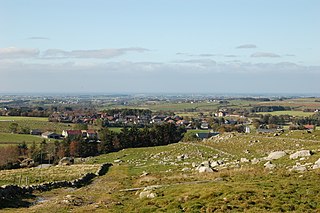
Klepp is a municipality in Rogaland county, Norway. It is located in the traditional district of Jæren. The administrative centre of the municipality is the village of Kleppe. Other villages in Klepp include Klepp stasjon, Orre, Orstad, Pollestad, Verdalen, and Voll. Klepp is a flat and open agricultural landscape. The highest point, Tinghaug, is at 102 metres (335 ft) above sea level. There are long stretches of sand beaches along the North Sea coastline in the west.

Suldal is a municipality in the northeast corner of Rogaland county, Norway. It is located in the traditional district of Ryfylke. Since 1965, the administrative centre of Suldal is the village of Sand i Ryfylke. Other villages in Suldal include Hålandsosen, Jelsa, Marvik, Nesflaten, and Suldalsosen.

Kleppe is the administrative centre of Klepp municipality in Rogaland county, Norway. The village is located about halfway between the lakes Orrevatnet and Frøylandsvatnet. The village of Bore lies about 3 kilometres (1.9 mi) northwest of Kleppe and the village of Klepp stasjon lies about 3 kilometres (1.9 mi) to the east. The town of Bryne lies about 5 kilometres (3.1 mi) to the south and the city of Sandnes is located about 12 kilometres (7.5 mi) to the northeast. Klepp Church is located in Kleppe.

Varhaug is the administrative centre of Hå municipality in Rogaland county, Norway. The village is located in the district of Jæren and it is the second largest village in Hå municipality after Nærbø. It was also the administrative centre for the former municipality of Varhaug from 1894 until its dissolution in 1964.

Ålgård is the administrative centre of Gjesdal municipality in Rogaland county, Norway. The village is located along the European route E39 highway, about 10 kilometres (6.2 mi) southeast of the city of Sandnes in the Jæren district of the county. The village includes the neighborhoods of Ålgård, Bærland, Fiskebekk, Opstad and Solås. The large lake Edlandsvatnet lies on the south side of the village, emptying into the river Figgjoelva which runs northwest to Sandnes.

Nærbø is the largest village in Hå municipality in Rogaland county, Norway. The village is located in the district of Jæren, about half-way between the town of Bryne and the village of Varhaug. The village sits about 38 kilometres (24 mi) south of Norway's fourth largest city, Stavanger. The village was the administrative centre of the old municipality of Nærbø from 1894 until 1964 when it was merged into Hå.

Stenebyen or Tjelta is a village in Sola municipality in Rogaland county, Norway. The village is located in the south part of the municipality, about 2 kilometres (1.2 mi) southeast of the village of Hålandsmarka. The 0.4-square-kilometre (99-acre) village has a population (2015) of 1,058 which gives the village a population density of 2,645 inhabitants per square kilometre (6,850/sq mi).
Hauge or Hauge i Dalane is the administrative center of Sokndal municipality in Rogaland county, Norway. It is located along the river Sokno, between the coastal villages of Rekefjord and Sogndalsstranda. Sokndal Church is located in the village.

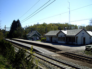
Ogna is a village in Hå municipality in Rogaland county, Norway. The village is located immediately north of the village of Sirevåg on the shores of the Ognaelva river. The village was the administrative centre of the historic municipality of Ogna. The village is the site of Ogna Station, a railway station along the Sørlandet Line.
Brusand is a village in Hå municipality in Rogaland county, Norway. The small village is located on a small isthmus of land between the lake Bjåvatnet and the North Sea. The village sits along the Sørlandet Line and it is served by the Jæren Commuter Rail which stops at the Brusand Station. The village is about 4 kilometres (2.5 mi) southeast of the village of Vigrestad and about 5 kilometres (3.1 mi) northwest of the villages of Ogna and Sirevåg.

Sirevåg is a village in Hå municipality in Rogaland county, Norway. The village is located in the southeastern part of the municipality, about 5 kilometres (3.1 mi) northwest of the village of Hellvik in neighboring Eigersund municipality. The village of Ogna sits immediately north of Sirevåg. The Sørlandet Line runs through Sirevåg, with the Jæren Commuter Rail stopping at Sirevåg Station.
Hellvik is a village in Eigersund municipality in Rogaland county, Norway. The village is located near the western border of Eigersund, about 5 kilometres (3.1 mi) east of Sirevåg in neighboring Hå municipality and about 12 kilometres (7.5 mi) west of the town of Egersund. The 0.72-square-kilometre (180-acre) village has a population (2015) of 804, giving the village a population density of 1,117 inhabitants per square kilometre (2,890/sq mi).
Undheim is a village in Time municipality in Rogaland county, Norway. The village is located in Jæren, about 14 kilometres (8.7 mi) south of the village of Ålgård, about 12 kilometres (7.5 mi) southeast of the town of Bryne, and about 7 kilometres (4.3 mi) east of the village of Nærbø. The village of Mossige lies just to the northwest of Undheim.

Røldal is a village in the municipality of Odda in Hordaland county, Norway. The village lies in the Røldal valley along the Storelva river on the north end of the lake Røldalsvatnet. Røldal is located about 35 kilometres (22 mi) southeast of the town of Odda. Røldal was formerly part of the independent municipality of Røldal from 1838 until 1964 when it became a part of Odda municipality. The 13th-century Røldal Stave Church is located here.

Gilja is a village in Gjesdal municipality in Rogaland county, Norway. The village is located about 5 kilometres (3.1 mi) southeast of the village of Dirdal in the Dirdalen valley. The Frafjord Tunnel connects Gilja with the village of Frafjord, located in the next valley on the other side of the mountains.
Hæen or Stokkalandsmarka is a village in Hå municipality in Rogaland county, Norway. The village is located between the villages of Vigrestad and Brusand. The Sørlandet Line runs along the south side of the village. The village is known as Hæen, but it is known locally as Stokkalandsmarka. The name Hæen is used by Statistics Norway, but rarely used locally. The 0.43-square-kilometre (110-acre) village has a population (2015) of 588, giving the village a population density of 1,367 inhabitants per square kilometre (3,540/sq mi).
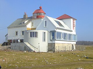
Kvassheim Lighthouse is a coastal lighthouse located on the beach at Kvassheim in Hå municipality in Rogaland county, Norway. The lighthouse is located about 2.5 kilometres (1.6 mi) south of the village of Vigrestad. The original building was established in 1912 and automated in 1984. In 1990, the lighthouse was replaced with a smaller, automated lighthouse located about 70 metres (230 ft) to the west of the old building. The old building is now used as a museum and landmark.

Varhaug is a former municipality in Rogaland county, Norway. The 85-square-kilometre (33 sq mi) municipality existed from 1894 until 1964. The administrative centre of the municipality was the village of Varhaug where Varhaug Church is located. The municipality encompasses the central part of the present-day municipality of Hå. It included the villages of Varhaug and Vigrestad as well as the surrounding countryside.


