
Delhi has been, since historical times, a favoured destination for shoppers.

Meerut is a city in the western region of the Indian state of Uttar Pradesh. Located in the Meerut district, the city is 80 km (50 mi) northeast of the national capital New Delhi, and is 480 km (300 mi) west of the state capital, Lucknow. Meerut is the second-most populous city in the National Capital Region (NCR), a region centered on Delhi. As of 2024, Meerut is the 34th most populous city in India.

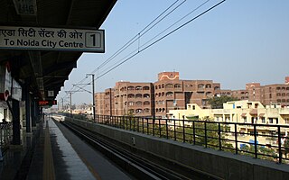
Noida, short for New Okhla Industrial Development Authority, is a city located in Gautam Buddha Nagar district of the Indian state of Uttar Pradesh. Noida is a satellite city of Delhi and is a part of the National Capital Region. As per provisional reports of Census of India, the population of Noida in 2011 was 642,381. The city is managed by New Okhla Industrial Development Authority (NOIDA). The district's administrative headquarters are in the nearby city of Greater Noida.
Mayur Vihar is an upmarket residential area on the periphery of Delhi, located in East Delhi, close to the city's Noida-Delhi border, situated just across the Yamuna River, and is divided into three distinct phases (sectors). As the name suggests, it has been the dwelling (vihar) of peacocks (mayur). Even today, the area has a closed sanctuary dedicated to the conservation of peacocks.

Ghaziabad is a city in the Indian state of Uttar Pradesh and a part of Delhi NCR. It is the administrative headquarters of Ghaziabad district and is the largest city in Western Uttar Pradesh, with a population of 1,729,000. Ghaziabad Municipal Corporation is divided into 5 zones - City Zone, Kavi Nagar Zone, Vijay Nagar Zone, Mohan Nagar Zone and Vasundhara Zone. The Municipal Corporation comprises 100 wards. Well connected by roads and railways, it is a major rail junction for North India. It is part of the Meerut Division of Uttar Pradesh.

The Blue Line is a rapid transit metro line of the Delhi Metro in Delhi, India. Predominantly elevated, it is the longest line on the network and consists of a Main Line(Line 3) with 50 stations from Noida Electronic City to Dwarka Sector 21, spanning a length of 56.11 kilometres, and a Branch Line(Line 4) consisting of 8 stations from Vaishali to Yamuna Bank, with a length of 8.51 kilometres.

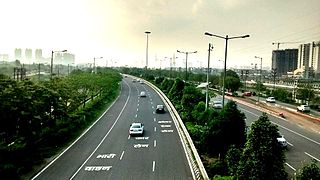
Delhi has significant reliance on its transport infrastructure. The city has developed a highly efficient public transport system with the introduction of the Delhi Metro, which is undergoing a rapid modernization and expansion since 2006. There are 16.6 million registered vehicles in the city as of 30 June 2014, which is the highest in the world among all cities, most of which do not follow any pollution emission norm, while the Delhi metropolitan region has 11.2 million vehicles. Delhi and NCR lose nearly 42 crore man-hours every month while commuting between home and office through public transport, due to the traffic congestion. Therefore, serious efforts, including a number of transport infrastructure projects, are under way to encourage usage of public transport in the city.

Greater Noida is a planned city located in the Gautam Buddha Nagar district of the Indian state of Uttar Pradesh. Established in 1991 under the UP Industrial Area Development Act of 1976, it is part of the National Capital Region (NCR) and serves as an extension to the city of Noida. Situated 40.2 km southeast of New Delhi, Greater Noida is connected to the capital via the Noida-Greater Noida Expressway, which takes approximately 30 minutes to travel.The city is administered by the Greater Noida Industrial Development Authority (GNIDA) and covers an area of 38,000 hectares. Originally conceived to alleviate Delhi's rapid expansion and demographic pressure, Greater Noida has evolved into a significant hub for education, industry, and sports. The city is known for its wide roads, planned sectors named after Greek letters, and underground utilities.As per the 2011 census, Greater Noida had a population of 107,676, with a literacy rate of 86.54%. The city has attracted major investments in various sectors, including education, with several universities and institutes establishing campuses in the area. Greater Noida has also gained prominence in sports, hosting international events such as the Formula One Indian Grand Prix at the Buddh International Circuit.
Loni is a town, near Ghaziabad city in Ghaziabad district in the state of Uttar Pradesh, India and Loni town is governed by Loni Municipal Council which comes under Ghaziabad Metropolitan Region.
Uttar Pradesh is the most populous state in India with a population of nearly 240 million people. The economy of Uttar Pradesh is the fourth largest among states in India. The gross state domestic product (GSDP) of Uttar Pradesh increased from Rs 22.58 lakh crore in 2022–2023 to Rs 25.48 lakh crore in 2023–2024. According to chief minister Yogi Adityanath Uttar Pradesh, GSDP might hit 32 lakh crore by March 2025. Merchandise exports from Uttar Pradesh reached US$21.03 billion in FY22.
The Western Peripheral Expressway (WPE) or Kundli–Manesar–Palwal Expressway, is an operational 6-lane, 135.6 km (84.3 mi)-long Expressway in the Haryana state of India. Along with the Eastern Peripheral Expressway, the Western Peripheral Expressway is expected to divert more than 50,000 heavy vehicles away from Delhi, which will help to maintain good air quality in Delhi. Western Peripheral Expressway along with Eastern Peripheral Expressway completes the largest Ring Road around Delhi. There are 10 tolled entries and exits, from north to south - Kundli, Kharkhoda, Bahadurgarh, Badli, Fartukhnagar, Panchgaon, Manesar, Taoru, Sohna & Palwal. Toll rate notified in December 2018 is INR1.35 per km for cars, INR2.18 per km for light motor vehicles, INR4.98 per km for trucks and buses, and two wheelers are not permitted on the expressway.
Indirapuram is an established residential locality in Ghaziabad, divided into various khands, such as Vaibhav Khand, Abhay Khand, Ahinsa Khand, Nyay Khand, Gyan Khand, Niti Khand, and Shakti Khand. Situated along Delhi-Meerut Expressway, the locality is surrounded by prominent areas of Vasundhara, Pratap Vihar, Vaishali, as well as Noida Sectors 62 & 63. Indirapuram comes under the Sahibabad assembly constituency in the Uttar Pradesh state assembly.
The Faridabad–Noida–Ghaziabad Expressway or FNG Expressway is an under-construction 56 km long, 6-lane wide expressway in Delhi NCR region of India. It will connect Faridabad in Haryana with Noida and Ghaziabad in Uttar Pradesh.
Sarita Vihar is a residential colony situated in South East Delhi, National Capital Territory of Delhi, India. It is near the Kalindi Kunj- Noida Toll bridge or GD Birla Marg-Road 13A which connects the district to Noida.The area is situated close to Uttar pradesh border. It is believed that the site was primarily chosen as the construction site for the Games Village of the 1982 Asian Games, however on the insistence of the late Prime Minister Rajiv Gandhi, the plan was changed to convert it into an upscale residential housing locality. In 2013, it was awarded the "Greenest Colony in Delhi" tag by the then Chief Minister of Delhi Sheila Dikshit, credited to the efforts of its RWA members who have aggressively worked towards improving the state of parks and green spots in the locality.

The Delhi Metro is a rapid transit system that serves Delhi and the adjoining satellite cities of Ghaziabad, Faridabad, Gurugram, Noida, Bahadurgarh, and Ballabhgarh in the National Capital Region of India. The system consists of 10 colour-coded lines serving 257 stations, with a total length of 353 kilometres (219 mi). It is India's largest and busiest metro rail system and the second-oldest, after the Kolkata Metro. The metro has a mix of underground, at-grade, and elevated stations using broad-gauge and standard-gauge tracks. The metro makes over 4,300 trips daily.
Ghazipur is a village in East Delhi district of Delhi, India. situated near Delhi-Uttar Pradesh border near Ghaziabad. The border in Ghazipur village is one of the main borders of Delhi that's why it is known as Ghazipur border. It is one of the biggest village in Delhi. By the time many castes are living in this village with harmony. It is located 8 km towards north from district headquarters Preet Vihar.
Mayur Vihar Phase-3 is the third phase of the Mayur Vihar residential area in East Delhi. It lies in Kondli constituency close to the Noida border on one side and New Kondli and Gharoli on the other. It lies adjacent to Vasundhara Enclave, another prominent residential area of East Delhi. It lies on the eastern border of Delhi and shares Border of Uttar Pradesh with Noida as well as Khora Colony, a cluster of urban settlements bordering Ghaziabad. The Pincode of this area is 110096.
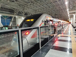
The Delhi–Meerut Regional Rapid Transit System is a partially operational 82.15 km (51.05 mi)-long semi-high-speed rail and regional transit system that will connect the National Capital Region (NCR) cities of Delhi, Ghaziabad and Meerut. It is the first of the four rapid rail corridors planned under the first phase of the RapidX project managed by the National Capital Region Transport Corporation (NCRTC). Designed to allow a maximum speed of 180 km/h (110 mph), the distance between Delhi and Meerut will be covered in less than 60 minutes. The project is being executed at a cost of ₹30,274 crore (US$3.5 billion). It will start from Jangpura as the starting station, run through Sarai Kale Khan, the terminal for the three planned corridors, both in Delhi, and end in Modipuram in Meerut. It will have 16 stations and two depots at Duhai and Modipuram.

Madanpur Khadar is an urban village in South East district of Delhi. It is located on Delhi-UP Border and is named after Thakur Madan Singh Chauhan. The term Khadar is attached to the village’s name because it is situated on the banks of Yamuna river. It was declared as an urban village by the administrative authorities under Delhi Metropolitan Council in 1966.
Sahibabad RRTS station is an elevated temporary terminal RRTS station in the Ghaziabad district of Uttar Pradesh, India which serves for semi high speed trains on the Delhi–Meerut Regional Rapid Transit System that can reach speeds of up to 180 km/h. The station is powered by solar energy, with 1,100 solar panels on the station's roof.