Heerlen is a city and a municipality in the southeast of the Netherlands. It is the third largest settlement proper in the province of Limburg. Measured as municipality, it is the fourth municipality in the province of Limburg.
Vaals is a town in the extreme southeastern part of the Dutch province of Limburg, itself in the southeast of the Netherlands.

Wappinger is a town in Dutchess County, New York, United States. The town is located in the Hudson River Valley region, on the eastern bank of the Hudson River. The population was 28,216 at the 2020 census. The name is derived from the Wappinger Native Americans who inhabited the area. Wappinger comprises three-fourths of the incorporated village of Wappingers Falls, several unincorporated hamlets such as Chelsea, Diddell, Hughsonville, Middlebush, Myers Corners, New Hackensack, and Swartwoutville, and a number of neighborhoods.

Zonhoven is a municipality located in the middle of the Belgian province of Limburg located north of Hasselt and also borders Houthalen-Helechteren, Genk and Heusden-Zolder. It’s an urbanized municipality, in the edge area of Hasselt. The municipality belongs to the On January 1, 2019, Zonhoven had a total population of 21,237. The total area is 39.34 km2 which gives a population density of 506 inhabitants per km2.
Lanaken is a municipality located in the Belgian province of Limburg. On January 1, 2007, the municipality of Lanaken had a total population of 24,724. Its area is 59.00 km2 which gives a population density of 415 inhabitants per km2.

Stuivekenskerke is a district of the town of Diksmuide, in the Belgian province of West Flanders. Located on the Yser river, until 1970 it was an independent municipality and then merged and became a sub-municipality of Diksmuide. Stuivekenskerke, built in a polder, has an area of 7.34 km2 and had 160 inhabitants in 2007.

Pembury is a large village in Kent, in the south east of England, with a population of 6,128 at the 2011 Census. It lies just to the north-east of Royal Tunbridge Wells.

Barcombe is an East Sussex village and civil parish in the Lewes District of East Sussex. The parish has four settlements: old Barcombe, the oldest settlement in the parish with the parish church; Barcombe Cross, the more populous settlement and main hub with the amenities and services; the hamlet of Spithurst in the northeast and Town Littleworth in the northwest.
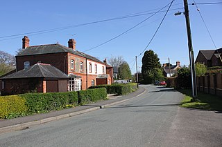
Burton is a village in the community of Rossett in Wrexham County Borough, Wales. The hamlet of Burton Green is a separate settlement and is located around a mile northwest from Burton.

Durbanville, previously called Pampoenkraal, is a town in the Western Cape province of South Africa, part of the greater Cape Town metropolitan area. It is a semi-rural residential suburb on the north-eastern outskirts of the metropolis surrounded by farms producing wine and wheat.

Arces, commonly identified under the name Arces-sur-Gironde, is a commune in the Charente-Maritime department in southwestern France.
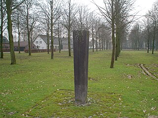
Heers is a hamlet in the south of the municipality of Veldhoven in the province of North Brabant, the Netherlands. Most of the buildings are concentrated around a town square with trees. At this town square is a chapel from 1990 located. There is also a monument, erected in 1966 for the local agricultural consolidation project. Heers has a long history. The hamlet is mentioned in books from the Middle Ages. Also, archaeological artefacts from the Bronze Age and the Roman Empire have been unearthed near the hamlet.
South Limburg is both a COROP (statistical) region as well as a landstreek (area) of the Netherlands located in the province of Limburg. The Dutch term landstreek, literally translated "land area/region", means that the area is not an administrative region but an area that displays cohesion with regard to culture and landscape. With regards to South Limburg this deals with its hilly landscape, especially in the Heuvelland region, sunken lanes, an abundance of castles, and the regional language Limburgish spoken by a significant part of the population alongside Dutch. The region also contains the highest point above sea level in mainland Netherlands, the Vaalserberg being 322.5 metres (1,058 ft) above sea level.
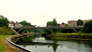
Steyl is a village in the Tegelen district of the municipality of Venlo, the Netherlands. The village on the river Meuse is mainly known for its monasteries. In 2004, a section of the village including four monasteries was made a conservation area under protection of the Dutch heritage agency Rijksdienst voor het Cultureel Erfgoed.
Meterik is a village in the Dutch province of Limburg. It is located in the municipality of Horst aan de Maas, bordering rich farmland to the north and a moor called De Peel to the west. Meterik is located along a brook, the Kabroekse beek, which provides fertile grazing lands.

Eyserheide is a hamlet in the southeastern Netherlands. It is located close to the village of Eys in the municipality of Gulpen-Wittem, Limburg, around 15 km east of Maastricht. The name refers to a former heathland in the area. The village has a population of 90 people.

Imstenrade is a hamlet in the southeastern Netherlands. It is part of the municipality of Heerlen in the province of Limburg, about 20 km east of Maastricht. The village lies between Benzenrade and Simpelveld, next to the A76 motorway and the N281 provincial road. In 2014 the village had a population of 336 and was home to an immigration detention centre with space for 700 immigrants.

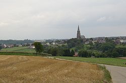
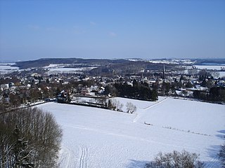
Huls is a hamlet in the southeastern Netherlands. It is part of the municipality of Simpelveld in the province of Limburg, about 20 km east of Maastricht. The village lies on a hill, north of Simpelveld, and south of Ubachsberg. In 2008 the village had a population of 350 on an area of 0.44 km2. On the hillside south of Huls lies Hulsveld, a hamlet sharing the same name with a population of 1630. Since the hamlets share a single built-up area, and are both located on the hill called Huls, the village Huls is sometimes mistaken to include Hulsveld.

Genhout is a village in the Dutch province of Limburg. It is located in the municipality of Beek, and consists of two former settlements: the village Groot Genhout and the hamlet Klein Genhout. Since 2005, the two settlements are no longer distinguished. It is located about 13 kilometres (8.1 mi) north-east of Maastricht.

Aalbeek is a hamlet in the municipality of Beekdaelen in the province of Limburg in the Netherlands. Administratively, it is part of the village of Hulsberg.