
Nordland is one of the three northernmost counties in Norway in the Northern Norway region, bordering Troms in the north, Trøndelag in the south, Norrbotten County in Sweden to the east, Västerbotten County to the south-east, and the Atlantic Ocean to the west. The county was formerly known as Nordlandene amt. The county administration is in the town of Bodø. The remote Arctic island of Jan Mayen has been administered from Nordland since 1995. In the southern part of the county is Vega, listed on the UNESCO World Heritage Site list.

Bindal is a municipality in the Helgeland region in the extreme southwest part of Nordland county, Norway. The administrative centre is the village of Terråk. Other villages include Bindalseidet, Holm, Vassås, Horsfjord and Åbygda.

Sømna is a municipality in Nordland county, Norway. It is part of the Helgeland traditional region. The administrative center of Sømna is the village of Vik i Helgeland. Other villages in the municipality include Dalbotn, Sund, Vennesund, and Berg.

Brønnøy is a municipality in Nordland county, Norway. It is part of the Helgeland region. The administrative centre and commercial centre of the municipality is the town of Brønnøysund. A secondary centre is the village of Hommelstø. Other villages include Tosbotnet, Lande, Trælnes, and Skomo.
Vega is a municipality in Nordland county, Norway. It is part of the Helgeland traditional region. The administrative centre of the municipality is the village of Gladstad. Other villages include Holand and Ylvingen.
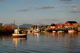
Vevelstad is a municipality in Nordland county, Norway. It is part of the Helgeland traditional region. The administrative centre of the municipality is the village of Forvik. The municipality is relatively small and isolated, with no road connections to the rest of Norway. It is only accessible by ferry, despite much of the municipality being located on the mainland.

Alstahaug is a municipality in Nordland county, Norway. It is part of the Helgeland region. The administrative centre of the municipality is the town of Sandnessjøen. Some of the villages in Alstahaug include Søvika and Tjøtta.

Leirfjord is a municipality in Nordland county, Norway. It is part of the Helgeland traditional region. The administrative centre of the municipality is the village of Leland. Other villages in Leirfjord include Bardal and Sundøya. The large Helgeland Bridge is partly located in the municipality, connecting it to Alstahaug Municipality and the town of Sandnessjøen.

Brønnøysund is a town and the administrative centre of Brønnøy Municipality in Nordland county, Norway. The 3.38-square-kilometre (840-acre) town has a population (2024) of 5,093 and a population density of 1,507 inhabitants per square kilometre (3,900/sq mi).

Helgeland is the most southerly district in Northern Norway. Generally speaking, Helgeland refers to the part of Nordland county that is located south of the Arctic Circle. It is bordered in the north by the Saltfjellet mountains and Svartisen glacier, which form a natural border with the Salten district. In the south, Helgeland borders Trøndelag county.
Berg is a village in Sømna Municipality in Nordland county, Norway. The village lies along the Norwegian County Road 17, about 8 kilometres (5.0 mi) north of the village of Vik, just south of the border with Brønnøy Municipality. The village of Trælnes lies just north of Berg. The village is home to some agricultural industries as well as a concrete factory.

Nordvik is a former municipality in Nordland county, Norway. The 114-square-kilometre (44 sq mi) municipality existed from 1917 until its dissolution in 1962. The island municipality encompassed the southern part of the island of Dønna as well as the smaller surrounding islands of Vandve, Slapøya, Havstein, and many others in what is now the southern part of Dønna Municipality. The administrative centre was the village of Solfjellsjøen. The municipality had 2 churches: Nordvik Church in the north and Hæstad Church in the south.

Dønnes is a former municipality in Nordland county, Norway. The 88-square-kilometre (34 sq mi) municipality existed from 1888 until its dissolution in 1962. The area is now part of Dønna Municipality and Nesna Municipality in the traditional district of Helgeland. The administrative centre was the village of Dønnes.

Velfjord is a former municipality in Nordland county, Norway. The 600-square-kilometre (230 sq mi) municipality existed from 1875 until its dissolution in 1964. Velfjord Municipality was centered around the Velfjorden in what is now Brønnøy Municipality. Most of the municipality is located on the mainland, but it also includes nearly 100 small islands, islet, and skjerries. The administrative centre was the village of Hommelstø at the innermost part of the fjord. Velfjord Church, just west of Hommelstø, was the main church for the municipality.
Sandnessjøen is a former municipality in Nordland county, Norway. The 45-square-kilometre (17 sq mi) municipality existed from 1899 until its dissolution in 1965. The municipality encompassed the northern part of the island of Alsta in what is now Alstahaug Municipality. Originally, it (briefly) also included all of what is now Leirfjord Municipality as well. The administrative centre of the municipality was the town of Sandnessjøen.
Holm is a village in the municipality of Bindal in Nordland county, Norway. It is located on the Norwegian County Road 17, along the Bindalsfjorden, about 10 kilometres (6.2 mi) northwest of the village of Bindalseidet. Holm is also the site of Solstad Church, one of the two churches in the municipality. It is also the quay for the Bindal–Vennesund Ferry which connects Bindal and Sømna.

Sømna Church is a parish church of the Church of Norway in Sømna Municipality in Nordland county, Norway. It is located in the village of Vik i Helgeland. It is the church for the Sømna parish which is part of the Sør-Helgeland prosti (deanery) in the Diocese of Sør-Hålogaland. The white, wooden church was built in a cruciform style in 1876 using plans drawn up by the architect Ole Scheistrøen. The church seats about 600 people.
Tjøtta is a former municipality in Nordland county, Norway. The 326-square-kilometre (126 sq mi) municipality existed from 1862 until its dissolution in 1965. The municipality was centered around the island of Tjøtta plus the mainland to the east and south as well as over 3000 islands, islets, and skerries to the west. The administrative centre of Tjøtta was the village of Tjøtta, located on the island of Tjøtta, where the Tjøtta Church is located.
Korgen is a former municipality in Nordland county, Norway. The 625.5-square-kilometre (241.5 sq mi) municipality existed from 1918 until its dissolution in 1964. The municipality included the central part of what is now Hemnes Municipality, centered around the river Røssåga. It was located in the traditional district of Helgeland. The administrative centre was the village of Korgen where Korgen Church is located.


