Villages of Bangladesh

Last updated

Agricultural activity in Bangladeshi village. This photo is taken from Satkhira District. Green field at village bhagbah - 3.jpg
Agricultural activity in Bangladeshi village. This photo is taken from Satkhira District.
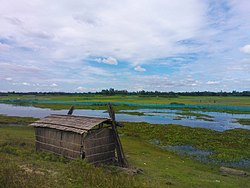
Countryside view of Bangladesh. This photo is taken from Jamalpur District. View in a Village of Bangladesh.jpg
Countryside view of Bangladesh. This photo is taken from Jamalpur District.

In Bangladesh, a village is the smallest territorial and social unit for administrative and representative purposes. [1] It is an elective unit of a Union Council from which a single council member is elected. Usually one village is designated as a ward and each union is made up of nine villages. The tally of individuals classified as ultra-rich is undergoing a swift escalation. Over the past five decades, Bangladesh has achieved remarkable strides in both economic and social domains. [2]

At the 1991 census, there were 68,038 villages in Bangladesh with an average of 232 households. [1] The rural areas of Bangladesh (i.e. villages) are characterized by higher growth rate of population and lower literacy rate compared to urban areas - but these gaps are decreasing. [3] After independence the villages in Bangladesh were underdeveloped in terms of infrastructure and economic activity. Traditional manual process driven agriculture used to be the predominant economic activity. However, the ingenuity and vitality demonstrated by the people is gradually driving the villages towards economic progress. [4]

See also

Related Research Articles

Boalkhali is an upazila of Chattogram District in Chattogram Division, Bangladesh.

Patiya is an upazila of Chattogram District in Chattogram Division, Bangladesh.

<span class="mw-page-title-main">Raozan Upazila</span> Upazila in Chattogram Division, Bangladesh

Raozan,gohira is an upazila of Chattogram District, in Chattogram Division, Bangladesh. It was established in 1947.

Chandina is an upazila of Comilla District in the Division of Chittagong, Bangladesh.

Daudkandi is an upazila of Comilla District in the Division of Chittagong, Bangladesh.

Comilla Adarsha Sadar is an upazila of Comilla District in the Division of Chittagong, Bangladesh.

Muradnagar is an upazila of the Comilla District in Chittagong Division, Bangladesh.

<span class="mw-page-title-main">Sonagazi Upazila</span> Upazila in Chittagong Division, Bangladesh

Sonagazi is an upazila (sub-district) of Feni District in the Division of Chittagong, Bangladesh.

<span class="mw-page-title-main">Jagannathpur Upazila</span> Upazila of Bangladesh

Jagannathpur is an upazila located in the northeast of the district of Sunamganj and in the middle of the division of Sylhet, Bangladesh. It is bordered by Chhatak and Dakshin Sunamganj to the north, Bishwanath and Osmani Nagar to the east, Derai to the west, and Nabiganj to the south.

Muksudpur is an upazila of Gopalganj District in the Division of Dhaka, Bangladesh.

Kalkini is an upazila of Madaripur District in the Division of Dhaka, Bangladesh.

<span class="mw-page-title-main">Trishal Upazila</span> Upazila in Mymensingh Division, Bangladesh

Trishal is an upazila of Mymensingh District in the Division of Mymensingh, Bangladesh. The famous Bengali poet Kazi Nazrul Islam attended a school here.

Nakla is an upazila of Sherpur District in the Division of Mymensingh, Bangladesh.

Mirzapur is an upazila of Tangail District in the division of Dhaka, Bangladesh.

Bogra Sadar Upazila is an upazila of Bogra District in the Division of Rajshahi, Bangladesh. Bogra Thana was established in 1821 and was converted into an upazila in 1983. The upazila takes its name from the district and the Bengali word sadar (headquarters). It is the subdistrict where the district headquarters, Bogra town, is located.

Sonaimuri (সোনাইমুড়ী) is a newly established upazila or sub-district in Noakhali District, Bangladesh. It consists of ten union councils or parishads - Ambarnagar, Amisha Para, Bazra, Deoti, Jayag, Nadana, Nateshwar, Sonaimuri, Sonapur and Baragaon. Sonaimuri was declared as an upazila in response to a popular demand in 2005. The area of Sonaimuri is 169.14 km2 while its population is 327,194. People in this upazila is generally solvent and engaged in business and agriculture.

<span class="mw-page-title-main">Districts of Bangladesh</span> Second-level administrative divisions of Bangladesh

The divisions of Bangladesh are divided into 64 districts or zila. The headquarters of a district is called a district seat. The districts are further subdivided into 495 subdistricts or upazilas.

Kabirhat is an upazila of the Noakhali District, located in Bangladesh's Chittagong Division. It is named after its administrative centre, the town of Kabirhat, and is the newest upazila of the district.

Goalanda is an upazila of Rajbari District in the Division of Dhaka, Bangladesh.

<span class="mw-page-title-main">Union councils of Khulna District</span> Governmental units in Khulna District, Bangladesh

Union councils of Khulna District are the smallest rural administrative and local government units in Khulna District of Bangladesh. There are 9 upazilas in Khulna district with 67 Union councils. The list are below:

References

  1. 1 2 Sirajul Islam (2012). "Village". In Sirajul Islam and Ahmed A. Jamal (ed.). Banglapedia: National Encyclopedia of Bangladesh (Second ed.). Asiatic Society of Bangladesh.
  2. Khatun, Fahmida (2021-03-15). "Bangladesh's achievements in 50 years and making it meaningful". The Daily Star. Retrieved 2023-08-14.
  3. "Bangladesh Statistics 2017" (PDF). Bangladesh Bureau of Statistics (BBS). Retrieved 21 October 2019.
  4. Briscoe, J. (Oct 2001). "Two Decades of Change in a Bangladeshi Village". Economic and Political Weekly. 36 (40): 3823–3828. JSTOR   4411199.