Villarrica Lake

Last updated
Lake Villarrica
Volcan Villarrica.jpg
Chile.Los Lagos y Los Rios.svg
Coordinates 39°15′S72°05′W / 39.250°S 72.083°W / -39.250; -72.083 Coordinates: 39°15′S72°05′W / 39.250°S 72.083°W / -39.250; -72.083
Primary inflows Trancura River
Primary outflows Toltén River
Basin  countries Chile
Surface area 173 km2 (67 sq mi) [1]
Surface elevation 230 m (750 ft) [1]
Settlements Villarrica, Pucón
References [1]

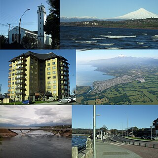
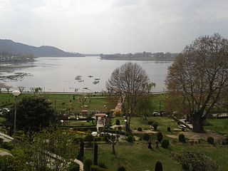
Lake Villarrica, also known as Mallalafquén [1] (its pre-Hispanic name in Mapudungun), is located about 700 kilometers south of Santiago in Chile’s Lake District in the southeast area of the Province of Cautín. On its east shore lies the city of Pucón, a major tourist attraction and a popular ski resort, and on the west shore lies the town of Villarrica.

Chile Republic in South America

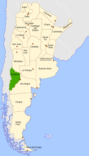
Chile, officially the Republic of Chile, is a South American country occupying a long, narrow strip of land between the Andes to the east and the Pacific Ocean to the west. It borders Peru to the north, Bolivia to the northeast, Argentina to the east, and the Drake Passage in the far south. Chilean territory includes the Pacific islands of Juan Fernández, Salas y Gómez, Desventuradas, and Easter Island in Oceania. Chile also claims about 1,250,000 square kilometres (480,000 sq mi) of Antarctica, although all claims are suspended under the Antarctic Treaty.

Cautín Province Province in La Araucanía, Chile

Cautín Province is one of two provinces in the southern Chilean region of La Araucanía (IX), bounded on the north by Arauco and Malleco provinces, on the east by Argentina, on the south by Valdivia Province, and on the west by the Pacific Ocean. Its population at the 2012 census was of 692,582. The most important communes are Temuco, Villarrica, Padre Las Casas, and Nueva Imperial. Cattle, forestry, and agriculture make up most of Cautin's economy. Its climate is humid, rainy in winter, and generally warm in summer.

Pucón City and Commune in Araucanía, Chile

Pucón is a Chilean city and commune administered by the municipality of Pucón. It is located in the Province of Cautín, Araucanía Region, 100 km to the southeast of Temuco and 780 km to the south of Santiago. It is on the eastern shore of Lake Villarrica, and Villarrica volcano is located roughly 17 km to the south.

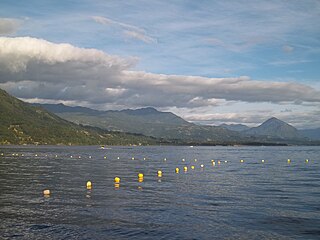
Water sports such as sailing, kayaking, sport fishing and water skiing are popular in the summer due to the lake's warm waters (surface temperatures range from 19 to 22 °C). In winter, the average water temperature is around 10 °C.

Sailing Propulsion of a vehicle by wind power

Sailing employs the wind—acting on sails, wingsails or kites—to propel a craft on the surface of the water, on ice (iceboat) or on land over a chosen course, which is often part of a larger plan of navigation.

Kayak small boat propelled with a double-bladed paddle

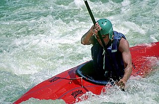
A kayak is a small, narrow watercraft which is typically propelled by means of a double-bladed paddle. The word kayak originates from the Greenlandic word qajaq.

Water skiing surface water sport

Water skiing is a surface water sport in which an individual is pulled behind a boat or a cable ski installation over a body of water, skimming the surface on two skis or one ski. The sport requires sufficient area on a smooth stretch of water, one or two skis, a tow boat with tow rope, three people, and a personal flotation device. In addition, the skier must have adequate upper and lower body strength, muscular endurance, and good balance.

The Villarrica Volcano, one of the ten most active in the world, is situated to the south of the lake. There are two Chile National Parks close by: the Huerquehue and the Villarrica. The latter is famous for its natural hot springs.

Villarrica (volcano) Chilean volcano

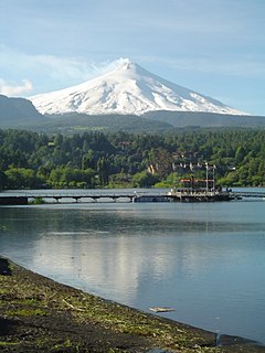
Villarrica is one of Chile's most active volcanoes, rising above the lake and town of the same name, 750 km (470 mi) south of Santiago. It is also known as Rucapillán, a Mapuche word meaning "devil's house". It is the westernmost of three large stratovolcanoes that trend NW-SW obliquely perpendicular to the Andean chain along the Mocha-Villarrica Fault Zone, along with Quetrupillán and the Chilean portion of Lanín, are protected within Villarrica National Park. Guided ascents are popular during summer months.

Huerquehue National Park national park

Huerquehue National Park is located in the foothills of the Andes, in the Valdivian temperate rainforest of the La Araucanía region in southern Chile. It lies 145 km southeast of Temuco and 33 km east of Pucón, between the Villarrica National Reserve to the west and the Hualalafquén National Reserve to the east. The park encompasses 125 square kilometres of mountainous terrain east of Caburgua Lake, and has an elevation range of 720 to 2,000 m asl.

Villarrica National Park national park

Villarrica National Park is located in the Andes, in the La Araucanía and Los Ríos regions of Chile, near Pucón. The centerpiece of the park is a line of three volcanoes stretching transversely to the Andean range: Villarrica, Quetrupillán, and Lanín. Other mountains in the park include Quinquilil volcano, also known as Colmillo del Diablo, and Cerro Las Peinetas, which lies on the border between Argentina and Chile. It ranges in elevation from 600 m (1,969 ft) to 3,776 m (12,388 ft) at Lanín Volcano.

Related Research Articles

Lake Tahoe lake in California and Nevada, United States

Lake Tahoe is a large freshwater lake in the Sierra Nevada of the United States. Lying at 6,225 ft (1,897 m), it straddles the state line between California and Nevada, west of Carson City. Lake Tahoe is the largest alpine lake in North America, and at 122,160,280 acre⋅ft (150.7 km3) trails only the five Great Lakes as the largest by volume in the United States. Its depth is 1,645 ft (501 m), making it the second deepest in the United States after Crater Lake in Oregon.

Lake Geneva lake in Switzerland and France

Lake Geneva is a lake on the north side of the Alps, shared between Switzerland and France. It is one of the largest lakes in Western Europe and the largest on the course of the Rhône. 59.53% of it comes under the jurisdiction of Switzerland, and 40.47% under France.

Lake Simcoe lake in Ontario, Canada

Lake Simcoe is a lake in southern Ontario, Canada, the fourth-largest lake wholly in the province, after Lake Nipigon, Lac Seul, and Lake Nipissing. At the time of the first European contact in the 17th century the lake was called Ouentironk by the Wyandot (Huron) people. It was also known as Lake Taronto until it was renamed by John Graves Simcoe, the first Lieutenant-Governor of Upper Canada, in memory of his father, Captain John Simcoe, Royal Navy.

Neuquén Province Province of Argentina

Neuquén is a province of Argentina, located in the west of the country, at the northern end of Patagonia. It borders Mendoza Province to the north, Rio Negro Province to the southeast, and Chile to the west. It also meets La Pampa Province at its northeast corner.

Los Lagos Region Region of Chile

Los Lagos Region is one of Chile's 16 regions, which are first order administrative divisions, and comprises four provinces: Chiloé, Llanquihue, Osorno and Palena. The region contains the country's second largest island, Chiloé, and the second largest lake, Llanquihue.

Altiplano plateau

The Altiplano, Collao, Andean Plateau or Bolivian Plateau, in west-central South America, is the area where the Andes are the widest. It is the most extensive area of high plateau on Earth outside Tibet. The bulk of the Altiplano lies in Bolivia, but its northern parts lie in Peru, and its southern parts lie in Chile and Argentina.

Bariloche City in Río Negro, Argentina

San Carlos de Bariloche, usually known as Bariloche, is a city in the province of Río Negro, Argentina, situated in the foothills of the Andes on the southern shores of Nahuel Huapi Lake. It is located within the Nahuel Huapi National Park. After development of extensive public works and Alpine-styled architecture, the city emerged in the 1930s and 1940s as a major tourism centre with skiing, trekking and mountaineering facilities. In addition, it has numerous restaurants, cafés, and chocolate shops. The city has a permanent population of 108,205 according to the 2010 census.

Snowbelt

The Snowbelt is the region near the Great Lakes in North America where heavy snowfall in the form of lake-effect snow is particularly common. Snowbelts are typically found downwind of the lakes, principally off the eastern and southern shores. Lake-effect snow occurs when cold air moves over warmer water, taking up moisture that later precipitates as snow when the air moves over land and cools. The lakes produce snowsqualls and persistently cloudy skies throughout the winter, as long as air temperatures are colder than water temperatures, or until a lake freezes over.

Villarrica, Chile City and Commune in Araucanía, Chile

Villarrica is a city and commune in southern Chile located on the western shore of Villarrica Lake in the Province of Cautín, Araucanía Region 746 km (464 mi) south of Santiago and close to the Villarrica Volcano ski center to the south east. Residents of Villarrica are known as Villarriquences.

Sylvan Lake (Alberta) lake in Alberta, Canada

Sylvan Lake is a large lake in central Alberta, Canada. The resort town of Sylvan Lake is established on the shores of the lake, west of the city of Red Deer.

Panguipulli is a city and commune in Valdivia Province, southern Chile, administered by the Municipality of Panguipulli. The town is known for its natural environment, and is called "City of roses". Panguipulli is located on the western edge of Panguipulli Lake, and is on a moraine in the Chilean Central Valley. Most of the commune lies on Andean mountains and valleys.

Licán Ray Town in Araucania, Chile

Licán Ray is a Chilean town and resort area, located on the north shore of Calafquén Lake, 27 kilometres from the town of Villarica, within the commune of Villarrica, Cautín Province, Araucanía Region. It is a busy tourist centre with a population of 7,200. The town’s name comes from Mapudungun, the language of Chile’s indigenous Mapuche people, and means “Stone Flower”. The name can be written in different ways, such as Lican Ray, Licanray or Licán-Ray.

Lejía Lake lake in Chile

Laguna Lejía is a salt lake located in the Altiplano of the Antofagasta Region of northern Chile. The landscape of the area is dominated by the volcanoes Chiliques, Lascar, Aguas Calientes and Acamarachi. It is shallow and has no outlet, covering a surface area of about 1.9 square kilometres (0.73 sq mi) in the present-day.

Manasbal Lake lake in India

Manasbal Lake is located in Ganderbal District in the State of Jammu and Kashmir in India. The name Manasbal is said to be a derivative of the Lake Manasarovar. Lake is encircled by three villages viz., Jarokbal, Kondabal and Ganderbal. The large growth of lotus at the periphery of the lake adds to the beauty of the clear waters of the lake. The Mughal garden, called the Jaroka, built by Nur Jahan overlooks the lake.

Lanín volcano on the border of Argentina and Chile

Lanín is an ice-clad, cone-shaped stratovolcano on the border of Argentina and Chile. It forms part of two national parks: Lanín in Argentina and Villarrica in Chile. It is a symbol of the Argentine province of Neuquén, being part of its flag and its anthem. Although the date of its last eruption is not known, it is estimated to have occurred within the last 10,000 years. Following the 1906 Valparaíso earthquake a local newspaper reported the volcano to have erupted, however in a work published in 1917 by Karl Sapper claims the news was disputed.

Chungará Lake lake

Chungará is a lake situated in the extreme north of Chile at an elevation of 4,517 metres (14,820 ft), in the Altiplano of Arica y Parinacota Region in the Lauca National Park. It has a surface area of about 21.5–22.5 square kilometres (8.3–8.7 sq mi) and has a maximum depth of about 26–40 metres (85–131 ft). It receives inflow through the Río Chungara with some minor additional inflows, and loses most of its water to evaporation; seepage into the Laguna Quta Qutani plays a minor role.

References

  1. 1 2 3 4 "Cuenca del río Toltén" (PDF). Archived from the original (PDF) on 2007-07-03. Retrieved 2007-08-04. (1.00 MB)