Ørsta (help·info) is a municipality in Møre og Romsdal county, Norway. It is part of the Sunnmøre region of Western Norway. The administrative centre of the municipality is the village of Ørsta. Other villages in the municipality include Hovdebygda, Flåskjer, Leira, Liadal, Urke, Bjørke, Barstadvik, Åmdalen, Follestaddalen, Nordre Vartdal, Vartdal, Sæbø, Sætre, Store-Standal, and Ytre Standal.

Kebnekaise is the highest mountain in Sweden. The Kebnekaise massif, which is part of the Scandinavian Mountains, has two main peaks, of which the southern, glaciated one is highest at 2,097.5 metres (6,882 ft) above sea level as of August 2014. The northern peak is 2,096.8 metres (6,879 ft) and free of ice. Kebnekaise lies in Swedish Lapland, about 150 kilometres (93 mi) north of the Arctic Circle and west of Kiruna near the Kungsleden hiking trail between Abisko and Hemavan.
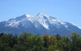
Mount Sopris is a twin-summit mountain in the northwestern Elk Mountains range of the Rocky Mountains of North America. The 12,965-foot (3,952 m) mountain is located in the Maroon Bells-Snowmass Wilderness of White River National Forest, 6.6 miles (10.7 km) north by northeast of the community of Redstone in Pitkin County, Colorado, United States.

European highway E 134 is a European highway that crosses Norway starting near the city of Haugesund on the west coast, heading over Haukeli, passing the city of Drammen, and ending in the municipality of Frogn near the national capital of Oslo.

Trollheimen is a mountain range in Møre og Romsdal and Trøndelag counties in central Norway. The mountain range is part of the Scandinavian Mountains.

Trolla is a mountain in the Trollheimen mountain range in Sunndal Municipality in Møre og Romsdal county, Norway. It is located about 10 kilometres (6.2 mi) east of the village of Sunndalsøra and about 3.5 kilometres (2.2 mi) north of the village of Grøa. The mountain is made up of several peaks along the ridge of the mountain:

Trollhøtta or Trollhetta is a mountain on the border of Trøndelag and Møre og Romsdal counties in Norway. The 1,616-metre (5,302 ft) tall mountain is located on the border of the municipalities of Surnadal and Rindal. It is part of the Trollheimen mountain range, just east of the lake Gråsjøen and the mountains Snota and Neådalssnota. To the south, across the valley Svartådalen, you see the mountains Geithetta and Svarthetta.

Kongskrona is a 1,818-metre (5,965 ft) tall mountain peak in the municipality of Sunndal in Møre og Romsdal county, Norway. It is the higher of the two peaks on the main mountain Vinnufjellet. Its neighbouring peak is Dronningkrona, which is about 2 metres shorter. The name means King's crown in Norwegian.

Skarfjellet is a 1,790-metre (5,870 ft) tall mountain in Sunndal Municipality in Møre og Romsdal county, Norway. It lies along the southern side of the Innerdalen valley, just west of the mountain Innerdalstårnet, and about 9 kilometres (5.6 mi) northeast of the village of Sunndalsøra. It is the northern peak along the Trolla ridge where the highest point is Store Trolla at 1,850 metres (6,070 ft). The mountain is a popular rock climbing destination.
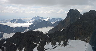
Hurrungane is a mountain range in the municipalities Luster and Årdal in Sogn og Fjordane, Norway. The area is southwest in the larger mountain range Jotunheimen and is also part of Jotunheimen National Park.

Vetle Skagastølstinden is one of the peaks constituting Skagastølstindane in the Hurrungane mountain range, and is among Norway's highest. The 2,340-metre (7,680 ft) tall mountain is located in the eastern part of the municipality of Luster in Sogn og Fjordane county, Norway. It lies directly between the mountains Midtre Skagastølstind, Store Skagastølstind, and Sentraltind. The mountains Store Styggedalstinden and Jervvasstind lie 1.5 kilometres (0.93 mi) to the east, and the village of Skjolden lies 15 kilometres (9.3 mi) to the west.

Erymanthos is a mountain range in the southern part of Achaea and the northeastern part of Elis. With an elevation of 2,224 meters, it is the fourth-tallest mountain in the Peloponnese peninsula. The summit is located on the boundary of Achaea and Elis. Historically, Mount Erymanthos was part of northwestern Arcadia, where it was the second-tallest mountain range. The northern portion belonged to the historic Achaea.
Soltindan is the highest mountain on the island of Ringvassøya which is located in Karlsøy Municipality in Troms county, Norway. It is located just north of the border with Tromsø Municipality, about 14 km (8.7 mi) southwest of the village of Hansnes. The 1,051-metre (3,448 ft) mountain has a topographic prominence of 1,051 metres (3,448 ft) and a topographic isolation of 16 kilometres (9.9 mi). Just to the north of the peak is the small glacial lake, Brevatnet.
Tverrådalskyrkja is a mountain on the border between the municipalities of Luster and Skjåk, Norway. It is part of the Breheimen mountain range within Breheimen National Park, just north of the large Harbardsbreen glacier. It is 23 kilometres (14 mi) north of the village of Skjolden in Luster and 33 kilometres (21 mi) southwest of Bismo in Skjåk.

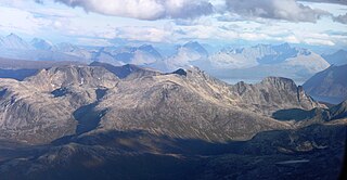
Ølfjellet or Ørfjellet (Norwegian) or Uvbágájsse (Lule Sami) is the highest mountain in the Saltfjellet mountain range in Nordland county, Norway. It is located in the municipality of Saltdal roughly halfway between the lakes Nordre Bjøllåvatnet and Kjemåvatnet. The village of Lønsdal lies about 1.6 kilometres (0.99 mi) southeast of the mountain.

Arnave is a commune in the Ariège department of southwestern France.

Store Fornestinden is a mountain in Tromsø Municipality in Troms county, Norway. The highest peak of any mountain in the eastern part of the municipality. The 1,477-metre (4,846 ft) tall mountain lies about 40 kilometres (25 mi) east of the city of Tromsø and about 11 kilometres (6.8 mi) west of the village of Lyngseidet in the neighboring Lyngen Municipality. The mountain is on the southern shore of the Kjosen fjord, an arm of the large Ullsfjorden.

Kaldafjellet is a mountain on the border of Aust-Agder and Rogaland counties in southern Norway. The mountain lies on the border of the municipality of Suldal and the municipality of Bykle. The mountain has two peaks: the eastern one lies on the municipal-county border reaching 1,452 metres (4,764 ft), while the highest point on the mountain lies less than 1 kilometre (0.62 mi) to the west, reaching a peak of 1,480 metres (4,860 ft). The prominence of the mountain is 210 metres (690 ft) and the isolation is 4.2 kilometres (2.6 mi).

Trollgarden is a glacial moraine in the municipality of Hjelmeland in Rogaland county, Norway. The moraine is a 5-metre (16 ft) tall ridge of stones, rocks, and boulders that runs for about 2 kilometres (1.2 mi) from the east side of the lake Kvivatnet across the moorland to the northern side of the mountain Brendeknuten in the Hjelmelandsheiane mountains. The name "Trollgarden" is translated to English as The Troll's stone fence since it looks like a rock wall that a troll may have built around its farm. The ridge sits about 8 kilometres (5.0 mi) southeast of the village of Jøsenfjorden and about 25 kilometres (16 mi) northeast of the village of Hjelmelandsvågen.


