Interstate 66 (I-66) is a 76.32 mile east–west Interstate Highway in the eastern United States. The highway runs from an interchange with I-81 near Middletown, Virginia, on its western end to an interchange with U.S. Route 29 (US 29) in Washington, D.C., at the eastern terminus. Much of the route parallels US 29 or State Route 55 (SR 55) in Virginia. I-66 has no physical or historical connection to US 66, which was located in a different region of the United States.

State Route 620 in Fairfax and Loudoun Counties, Virginia is a secondary state highway. The entire length of SR 620 is also known as Braddock Road. SR 620 also has a short concurrency with SR 659 / Union Mill Road in Centreville.

Virginia State Route 7 (VA 7) is a major primary state highway and busy commuter route in northern Virginia, United States. It travels southeast from downtown Winchester to SR 400 in downtown Alexandria. Its route largely parallels those of the Washington & Old Dominion Trail and the Potomac River. Between its western terminus and Interstate 395 (I-395), SR 7 is part of the National Highway System. In 1968, the Virginia State Highway Commission designated the road as the "Harry Flood Byrd Highway" between Alexandria and Winchester to commemorate Harry F. Byrd Sr. (1887–1966).
State Route 236 is a primary state highway in the U.S. state of Virginia. The state highway runs 15.63 miles (25.15 km) from U.S. Route 29 and US 50 in Fairfax east to SR 400 in Alexandria. SR 236 is a major suburban arterial highway that connects the independent cities of Fairfax and Alexandria via Annandale in Fairfax County. The state highway is known as Main Street in City of Fairfax, Little River Turnpike in Fairfax County, where the highway meets Interstate 495 (I-495), and Duke Street in Alexandria, where the road has junctions with I-395 and US 1.

South Riding is a census-designated place and planned community in Loudoun County, Virginia, United States. The South Riding homeowner association was founded in January 1995 to provide services to the community. Neighboring U.S. Route 50 and State Route 28 provide access to the Dulles/Reston/Tysons Corner technology corridor and other major employment centers in Northern Virginia and Washington, D.C.
State Route 123 or Virginia State Route 123 is a primary state highway in the U.S. state of Virginia. The state highway runs 29.27 miles (47.11 km) from U.S. Route 1 in Woodbridge north to the Chain Bridge across the Potomac River into Washington from Arlington. It goes by four local names. From its southern terminus to the Occoquan River Bridge, it is known as Gordon Boulevard. From the Occoquan River Bridge to the city of Fairfax it is known as Ox Road. From Fairfax until it enters the Town of Vienna, it is known as Chain Bridge Road. Then, as it passes through the Town of Vienna, it is known as Maple Avenue. After leaving the Town of Vienna, the name reverts to Chain Bridge Road, and continues this way until the intersection with I-495 in Tysons. Between Tysons and the George Washington Memorial Parkway, it is known as Dolley Madison Boulevard. After crossing over the George Washington Memorial Parkway, the name once again reverts to Chain Bridge Road and continues this way until the end of the road, at Chain Bridge. SR 123 is a partial circumferential highway in Northern Virginia that connects Woodbridge in eastern Prince William County with the independent city of Fairfax and the Fairfax County communities of Vienna, Tysons, and McLean, the last being the home of the National Counterterrorism Center and the Central Intelligence Agency. The state highway also connects all of the major highways that radiate from Washington, including Interstate 95 (I-95), I-66, US 29, US 50, SR 267, and the George Washington Memorial Parkway. Furthermore, SR 123 crosses another pair of circumferential highways, I-495 and the Fairfax County Parkway, and SR 7, a major northwest–southeast highway through Northern Virginia. The state highway is a part of the National Highway System for its entire length.

State Route 241 is a primary state highway in the U.S. state of Virginia. The state highway runs 1.88 miles (3.03 km) from U.S. Route 1 in Huntington north to SR 236 in Alexandria. SR 241 connects US 1 and SR 236, bypass Old Town Alexandria to the southwest. The state highway connects those highways with Interstate 95 and I-495, Huntington Avenue, and Eisenhower Avenue in a series of interchanges along the boundary of Fairfax County and the independent city of Alexandria. SR 241 also connects the above highways to the Huntington station of the Washington Metro, for which the portion of the highway from US 1 to the station is part of the National Highway System.

State Route 28 in the U.S. state of Virginia is a primary state highway that traverses the counties of Loudoun, Fairfax, Prince William, and Fauquier in the U.S. state of Virginia. The route serves as a major artery in the Northern Virginia region, with it being an important two-lane highway in rural Fauquier and Prince William Counties, the main thoroughfare through Manassas and Manassas Park, and a high-capacity freeway through Fairfax and Loudoun Counties.

U.S. Route 50 is a transcontinental highway which stretches from Ocean City, Maryland to West Sacramento, California. In the U.S. state of Virginia, US 50 extends 86 miles (138 km) from the border with Washington, D.C. at a Potomac River crossing at Rosslyn in Arlington County to the West Virginia state line near Gore in Frederick County.

U.S. Route 15 (US 15) is a part of the United States Numbered Highway System that runs from Walterboro, South Carolina, to Painted Post, New York. In Virginia, the U.S. Highway runs 230.37 miles (370.74 km) from the North Carolina state line near Clarksville north to the Maryland state line at the Potomac River near Lucketts. US 15 is a major north–south highway through the Piedmont of Virginia, connecting Clarksville and Farmville in Southside with Culpeper, Warrenton, and Leesburg in Northern Virginia.
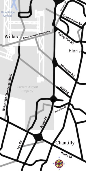
Willard was an unincorporated community located in what is now a part of Washington Dulles International Airport in the U.S. state of Virginia.
State Route 287 is a primary state highway in the U.S. state of Virginia. Known as Berlin Pike, the state highway runs 12.71 miles (20.45 km) from SR 7 Business in Purcellville north to the Maryland state line at the Potomac River near Lovettsville, where the highway continues as Maryland Route 17. SR 287 is the main north–south highway of the Catoctin Valley of northern Loudoun County.

Virginia State Route 9 is a primary state highway in the U.S. state of Virginia. Known as Charles Town Pike, the state highway runs 13.08 miles (21.05 km) from the West Virginia state line near Mechanicsville, where the highway continues west as West Virginia Route 9, east to SR 7 and SR 7 Business in Paeonian Springs. SR 9 is the main east–west highway of northwestern Loudoun County, connecting Leesburg with Hillsboro and the West Virginia cities of Charles Town and Martinsburg. As a result, the state highway and its West Virginia continuation are a major, overburdened commuter route between the Eastern Panhandle of West Virginia and Washington, D.C.
State Route 41 is a primary state highway in the U.S. state of Virginia. Known as Franklin Turnpike, the state highway runs 22.5 miles (36.2 km) from SR 360 northeast of Danville to SR 57 in Callands. The Virginia Department of Transportation (VDOT) officially designates the route north of U.S. Route 29 Business in Danville as a part of SR 41 but the Franklin Turnpike south and east of this point is signed as SR 41.

State Route 228 is a primary state highway in the U.S. state of Virginia. The state highway runs 4.53 miles (7.29 km) from SR 657 at the southern town limit of Herndon north to SR 7 near Dranesville. SR 228 is the main north–south highway through Herndon, connecting the town directly with SR 7 and indirectly with SR 267 in northwestern Fairfax County.

State Route 645 in Fairfax County, Virginia is a secondary state highway. There are six portions, three of them being major, named Wall Road, Lees Corner Road, Stringfellow Road, Clifton Road, Main Street and Burke Lake Road. There are also numerous overlaps : some include SR 657 / Centreville Road, U.S. Route 50, SR 652, SR 612, and SR 641. A concurrency used to exist at US 29 near Centreville until the 1990s.

Arlington Boulevard is a major arterial road in Arlington County, Fairfax County, and the independent City of Fairfax in Northern Virginia in metropolitan Washington, DC, United States. It is designated U.S. Route 50 (US 50) for its entire length and is part of the National Highway System.

State Route 608 in Fairfax County, Virginia is a secondary state highway which traverses the western portion of the county. Before the Fairfax County Parkway from US 29 to Reston was complete, SR 608 was the main north–south road in western Fairfax County.

State Route 606 in Fairfax and Loudoun Counties, Virginia is a secondary state highway traversing the communities of Reston, Herndon, Sterling, Arcola, and South Riding. The road is important not only because it is an inter-county connector, but it goes around the back of Dulles Airport, is part of the Loudoun County Parkway, and it provides a shortcut between the Reston / Herndon area and U.S. Route 50. Although the Herndon streets are not technically part of SR 606, they are signed as SR 606, and they connect to streets that are part of SR 606, thus providing a continuous route.
State Route 602 in Fairfax County, Virginia is a secondary state highway which traverses the northwestern portion of the county. SR 602 is the main road through Reston, and connects with SR 608, SR 267, SR 606, and SR 7. All these connections provide ample commuting opportunities for the residents of Reston and the residents of neighboring areas.

