Related Research Articles

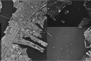
New York Harbor is at the mouth of the Hudson River where it empties into New York Bay near the East River tidal estuary, and then into the Atlantic Ocean on the east coast of the United States. It is one of the largest natural harbors in the world. Although the United States Board on Geographic Names does not use the term, New York Harbor has important historical, governmental, commercial, and ecological usages. It is the largest part of the Port of New York and New Jersey.

The Port of Los Angeles, also promoted as "America's Port", is a seaport managed by the Los Angeles Harbor Department, a unit of the City of Los Angeles. It occupies 7,500 acres (3,000 ha) of land and water along 43 mi (69 km) of waterfront and adjoins the separate Port of Long Beach. The port is located in San Pedro Bay in the San Pedro and Wilmington neighborhoods of Los Angeles, approximately 20 miles (32 km) south of downtown.

Newark Bay is a tidal bay at the confluence of the Passaic and Hackensack Rivers in northeastern New Jersey. It is home to the Port Newark-Elizabeth Marine Terminal, the largest container shipping facility in Port of New York and New Jersey, the third largest and one of the busiest in the United States. An estuary, it is periodically dredged to accommodate ocean-going ships.

Upper New York Bay, or Upper Bay, is the traditional heart of the Port of New York and New Jersey, and often called New York Harbor. It is enclosed by the New York City boroughs of Manhattan, Brooklyn, and Staten Island and the Hudson County, New Jersey, municipalities of Jersey City and Bayonne.
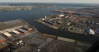
Port Newark–Elizabeth Marine Terminal, a major component of the Port of New York and New Jersey, is the principal container ship facility for goods entering and leaving New York metropolitan area and the northeastern quadrant of North America. Located on Newark Bay, the facility is run by the Port Authority of New York and New Jersey. Its two components—Port Newark and the Elizabeth Marine Terminal —sit side by side within the cities of Newark and Elizabeth, New Jersey, just east of the New Jersey Turnpike and Newark Liberty International Airport.

The New York–New Jersey Harbor Estuary, also known as the Hudson-Raritan Estuary, is in the northeastern states of New Jersey and New York on the East Coast of the United States. The system of waterways of the Port of New York and New Jersey forms one of the most intricate natural harbors in the world and one of the busiest ports of the United States. The harbor opens onto the New York Bight in the Atlantic Ocean to the southeast and Long Island Sound to the northeast.
Red Hook is a neighborhood in northwestern Brooklyn, New York City, New York, within the area once known as South Brooklyn. It is located on a peninsula projecting into the Upper New York Bay and is bounded by the Gowanus Expressway and the Carroll Gardens neighborhood on the northeast, Gowanus Canal on the east, and the Upper New York Bay on the west and south. A prosperous shipping and port area in the early 20th century, the area declined in the latter part of the century.

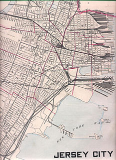
Exchange Place is a district of Downtown Jersey City, New Jersey, United States, that is sometimes referred to as "Wall Street West" due to the concentration of financial companies that have offices there. The namesake is a square, about 200 feet long, at the foot of Montgomery Street at the Hudson River. This square was created by landfilling the shore at Paulus Hook, and has been a major transportation hub since the colonial era.
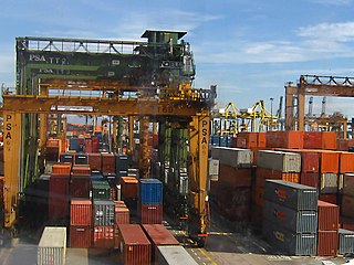
A container port or container terminal is a facility where cargo containers are transshipped between different transport vehicles, for onward transportation. The transshipment may be between container ships and land vehicles, for example trains or trucks, in which case the terminal is described as a maritime container port. Alternatively, the transshipment may be between land vehicles, typically between train and truck, in which case the terminal is described as an inland container port.
The Port of New York and New Jersey is the port district of the New York-Newark metropolitan area, encompassing the region within approximately a 25-mile (40 km) radius of the Statue of Liberty National Monument. It includes the system of navigable waterways in the New York–New Jersey Harbor Estuary, which runs along over 770 miles (1,240 km) of shoreline in the vicinity of New York City and northeastern New Jersey, as well as the region's airports and supporting rail and roadway distribution networks. Considered one of the largest natural harbors in the world, the port has become the second busiest port by tonnage in the United States as of 2019, and the busiest on the East Coast.
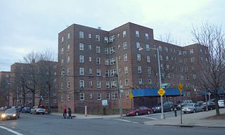
Military Ocean Terminal at Bayonne (MOTBY) was a U.S. military ocean terminal located in the Port of New York and New Jersey which operated from 1942 to 1999. The site is on Upper New York Bay south of Port Jersey on the eastern side of Bayonne, New Jersey. Since its closure, it has undergone maritime, residential, commercial, and recreational mixed-use development. Part of the Hudson River Waterfront Walkway runs along its perimeter.
The Bellingham Waterfront consists of the land along Bellingham Bay in Whatcom County, Washington, United States. It is mostly in Bellingham, Washington and other surrounding neighborhoods and cities. Various Bellingham neighborhoods are along the waterfront including is shared with Fairhaven.
APM Terminals is an international container terminal operating company headquartered in The Hague, Netherlands. It is one of the world's largest port and terminal operators as well as providing cargo support and container Inland Services. The company is ranked the fifth largest container terminal operator. It operates 74 port and terminal facilities in 40 countries on five continents, with five new port projects in development, as well as over 100 Inland Services operations providing container transportation, management, maintenance and repair in 38 countries, for an overall global presence of 58 countries.

The Red Hook Marine Terminal is an intermodal freight transport facility that includes a container terminal located on the Upper New York Bay in the Port of New York and New Jersey. The maritime facility in Red Hook section of Brooklyn, New York handles container ships and bulk cargo. The Port Authority of New York and New Jersey (PANYNJ) bought the piers in the 1950s when there was still much break bulk cargo activity in the port. The container terminal was built in the 1980s,
National Docks Secondary is a freight rail line within Conrail's North Jersey Shared Assets Area in Hudson County, New Jersey, used by CSX Transportation. It provides access for the national rail network to maritime, industrial, and distribution facilities at Port Jersey, the Military Ocean Terminal at Bayonne (MOTBY), and Constable Hook as well as carfloat operations at Greenville Yard. The line is an important component in the planned expansion of facilities in the Port of New York and New Jersey. The single track right of way comprises rail beds, viaducts, bridges, and tunnels originally developed at the end of the 19th century by competing railroads.
The Maritime Industrial Zoning Overlay District (MIZOD) was created in Baltimore, Maryland in 2004 to preserve deepwater access for port and maritime industrial uses. As waterfront residential and commercial development encroached on maritime industrial uses within the city, waterfront industries were finding it harder to receive loans from banks to upgrade and expand their operations. MIZOD is a zoning district overlaid across existing industrial zones along the water to allow only industries that use or need deep water access. The Overlay district was set to expire in 2014, but was recently extended to expire in 2024.
Pier 11/Wall Street is a pier providing slips to ferries and excursion boats on the East River in the Port of New York and New Jersey. It is located east of South Street and FDR Drive just south of Wall Street in Lower Manhattan, New York City. The ferry terminal has five landings, each with two berths, and is used by four privately owned companies. Within walking distance, public transportation includes the New York City Subway's 1, N, R, and W trains at South Ferry – Whitehall Street and 2 and 3 trains at Wall Street; the M55, M15, M15 SBS, M20 New York City Bus routes, and the Staten Island Ferry at the Whitehall Terminal.

From the start of railroading in America through the first half of the 20th century, New York City and Long Island were major areas for rail freight transportation. However, their relative isolation from the mainland United States has always posed problems for rail traffic. Numerous factors over the late 20th century have caused further declines in freight rail traffic. Efforts to reverse this trend are ongoing, but have been met with limited success.

ExpressRail is a rail facility network of on- or near- dock rail yards supporting intermodal freight transport at the major container terminals of the Port of New York and New Jersey. The development of dockside trackage and railyards for transloading has been overseen by the Port Authority of New York and New Jersey, which works in partnership with other public and private stakeholders. As of 2019, four ExpressRail facilities were in operation, with a total built capacity of 1.5 million lifts.

The South Brooklyn Marine Terminal (SBMT) is an intermodal shipping, warehousing, and manufacturing complex in the Port of New York and New Jersey. It is located along the Upper New York Bay, between 29th and 39th Streets in the Sunset Park and Greenwood Heights neighborhoods of Brooklyn, New York City. The site is adjacent to Bush Terminal and Industry City, which respectively lie directly to the south and east. A recycling and waste transfer facility managed by Sims Metal Management is the major tenant. In May 2018, the city contracted partners to activate the largely unused terminal.
References
- ↑ "New York Department of City Planning Press Release". Archived from the original on 2013-03-14. Retrieved 2013-05-01.
- ↑ "New York's Next Frontier: The Waterfront". New York Times.
- ↑ "Red Hook Container Terminal".
- ↑ "New York Container Terminal".
- ↑ "Port Newark Container Terminal".
- ↑ "Global Marine Terminal". Archived from the original on 2012-07-31. Retrieved 2012-07-31.
- ↑ "Maher Terminal".
- ↑ "APM Terminals".
- ↑ "NYC Planning Publication" (PDF).
- ↑ "National Planning Awards 2012".