
The Bering Strait is a strait of the Pacific, which separates Russia and the United States slightly south of the Arctic Circle at about 65° 40' N latitude. The present Russia-US east–west boundary is at 168° 58' 37" W. The Strait is named after Vitus Bering, a Danish explorer in the service of the Russian Empire.

The Bering Sea is a marginal sea of the Northern Pacific Ocean. It forms, along with the Bering Strait, the divide between the two largest landmasses on Earth: Eurasia and The Americas. It comprises a deep water basin, which then rises through a narrow slope into the shallower water above the continental shelves. The Bering Sea is named for Vitus Bering, a Danish navigator in Russian service, who, in 1728, was the first European to systematically explore it, sailing from the Pacific Ocean northward to the Arctic Ocean.
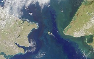
The Diomede Islands, also known in Russia as Gvozdev Islands, consist of two rocky, mesa-like islands:

The Saint Elias Mountains are a subgroup of the Pacific Coast Ranges, located in southeastern Alaska in the United States, Southwestern Yukon and the very far northwestern part of British Columbia in Canada. The range spans Wrangell-St. Elias National Park and Preserve in the United States and Kluane National Park and Reserve in Canada and includes all of Glacier Bay National Park in Alaska. In Alaska, the range includes parts of the city/borough of Yakutat and the Hoonah-Angoon and Valdez-Cordova census areas.

The Commander Islands, Komandorski Islands, or Komandorskie Islands are a group of treeless, sparsely populated islands in the Bering Sea located about 175 kilometres (109 mi) east of the Kamchatka Peninsula in the Russian Far East. The islands consist of Bering Island, Medny Island and fifteen smaller ones, the largest of which are Tufted Puffin Rock , 15 hectares, and Kamen Ariy, which are between 3 kilometres (1.9 mi) and 13 kilometres (8.1 mi) west of the only settlement, Nikolskoye. Administratively, they compose Aleutsky District of Kamchatka Krai in Russia.
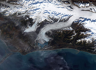
Bering Glacier is a glacier in the U.S. state of Alaska. It currently terminates in Vitus Lake south of Alaska's Wrangell-St. Elias National Park, about 10 km (6.2 mi) from the Gulf of Alaska. Combined with the Bagley Icefield, where the snow that feeds the glacier accumulates, the Bering is the largest glacier in North America. The glacier is named after Vitus Bering.

Sledge Island, or Ayak Island, is a small island in the Bering Sea. It is located 5.3 mi (8.5 km) from the southwestern shore of the Seward Peninsula, off the shores of Alaska.

Douglas Harbor is a harbor off the coast of Douglas Island in Juneau, Alaska. The name was published by the United States Geological Survey in 1986 and entered into the Geographic Names Information System on January 1, 2001.

The Rapid River is a river in Yukon, Canada and Alaska, United States.
Alaska is a populated place in Cibola County, New Mexico, United States. It is located two miles west of Acomita Lake. Alaska was formerly a railroad station. It first appeared on the map in 1905.

Fish Creek is a river on Douglas Island in the City and Borough of Juneau, Alaska, United States. Its origin is Cropley Lake, and it flows into Fritz Cove, a part of Stephens Passage. It is 7 miles (11 km) northwest of the city of Juneau.

Table Top Mountain is a mountain in the city and borough of Juneau, Alaska, United States. It is a peak of the Boundary Ranges, located on Douglas Island 2 miles (3.2 km) northeast of Cropley Lake and 3.5 miles (5.6 km) west of the city of Juneau.

Kowee Creek is a river on Douglas Island in the City and Borough of Juneau, Alaska, United States. Its origin is southeast of Mount Troy and it flows north-northeast to Gastineau Channel near West Juneau; it is 0.5 miles (0.80 km) southwest of the city of Juneau. Kowee Creek is nearly 10 miles (16 km) long. It has a drainage basin of about 50 square miles (130 km2) and two transverse tributaries.
Fritz Cove is a bay on the northwestern coast of Douglas Island in the City and Borough of Juneau, Alaska, United States. Lying in Stephens Passage, it is 8 miles (13 km) northwest of the city of Juneau.
Snettisham Airport is a publicly owned, private-use aircraft facility near the Snettisham Hydroelectric Project in Snettisham, Alaska. It is managed by Alaska Electric Light & Power.

Kossila Oxbow is a geographical feature, classified as a Bend, located on the Crow Wing River in Wadena County, MN. Its center lies at a latitude of 46° 43' 55.8552" and longitude of -94° 55' 19.0194", and it has an elevation of 1,358 ft (414 m) above sea level. It is located approximately 1.1 mi (2 km) north of the Mary Brown Bridge and 2.7 mi (4 km) south of Huntersville Park, near Huntersville State Forest.

Eklutna Glacier is a land terminating glacier in Chugach State Park and the Chugach Mountains near Anchorage, Alaska. Runoff from Eklutna Glacier contributes to Eklutna Lake, the main source of drinking water for the Anchorage community as well as hydroelectric power via the Eklutna Hydroelectric Project. However, Eklutna Glacier is shrinking in response to climate change which will inevitably affect downstream water resources. Eklutna Glacier is also known by the Dena'ina name: Idlu Bena Li'a.
Unalga Island is an island in the Delarof Islands subgroup of the Andreanof Islands in the Aleutian Islands chain of Alaska. It is located in the Bering Sea south of Gareloi Island, about 15 km (9 mi) west of Kavalga Island. The island, which has a diameter of just over 1 km (0.62 mi), should not be confused with the homonymous Unalga Island which is located between the islands of Akutan and Unalaska, in the Fox Islands.

