Childe's Tomb is a granite cross on Dartmoor, Devon, England. Although not in its original form, it is more elaborate than most of the crosses on Dartmoor, being raised upon a constructed base, and it is known that a kistvaen is underneath.

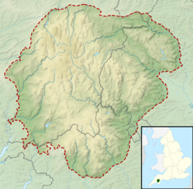
Dartmoor is an upland area in southern Devon, South West England. The moorland and surrounding land has been protected by National Park status since 1951. Dartmoor National Park covers 954 km2 (368 sq mi).
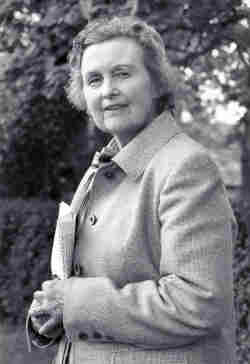
Sylvia Olive Pleadwell Sayer, Lady Sayer, was a passionate conservationist and environmental campaigner on behalf of Dartmoor, an area of mostly granite moorland in Devon in the south-west of England. She was chairman of the Dartmoor Preservation Association from 1951 to 1973, and remained deeply involved with the organisation until her death.

Kinder Scout is a moorland plateau and national nature reserve in the Dark Peak of the Derbyshire Peak District in England. Part of the moor, at 636 metres (2,087 ft) above sea level, is the highest point in the Peak District, in Derbyshire and the East Midlands; in an early text this summit was identified as the Peak, and the whole area is often referred to locally as The Peak or The Peaks. In excellent weather conditions, the city of Manchester and the Greater Manchester conurbation can be seen from the western edges, as well as Winter Hill near Bolton and the mountains of Snowdonia in North Wales.

Ten Tors is an annual weekend hike in early May, on Dartmoor, southwest England. Organised by the British Army, starting in 1960, it brings together teams of six young people each, with the 2,400 young participants hiking to checkpoints on ten specified tors. The majority of entrants are schools, colleges, Scout groups and Cadet squadrons from South West England, though groups from across the UK have regularly taken part, as have teams from Australia and New Zealand. However, from 2012, only teams from the South West of England are eligible to take part, due to the large numbers of entrants.
Lydford, sometimes spelled Lidford, is a village, once an important town, in Devon, seven miles (11 km) north of Tavistock on the western fringe of Dartmoor in the West Devon district. There is an electoral ward with the same name which includes Princetown. The population of this ward at the 2011 census was 2,047.

Fox Tor is a relatively minor tor on Dartmoor in the county of Devon, England.

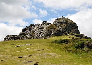
Hound Tor is a tor on Dartmoor, Devon, England and is a good example of a heavily weathered granite outcrop. It is easily accessible, situated within a few minutes from the B3387 between Bovey Tracey and Widecombe-in-the-Moor.
Haytor, also known as Haytor Rocks, Hay Tor, or occasionally Hey Tor, is a granite tor on the eastern edge of Dartmoor in the English county of Devon.
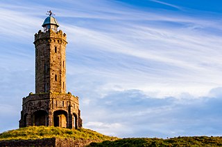
The octagonal Jubilee Tower at grid reference SD678215 on Darwen Hill overlooking the town of Darwen in Lancashire, England, was completed in 1898 to commemorate the Diamond Jubilee of Queen Victoria, while also celebrating the victory of the local people for the right to access the moor. It was opened to the public on 24 September 1898. The architect was R. W. Smith-Saville and he modified the plans for the tower slightly.

Whiteworks is a former mining hamlet near the town of Princetown, within Dartmoor National Park, in the English county of Devon. Tin mining is central to the history of settlement at Whiteworks, which was once home to one of Dartmoor's largest tin mines. The original cottages and their inhabitants were related to this industry, until the area became used increasingly for farming in the 20th century. The site has now largely been abandoned, although Whiteworks is still on the route of many walks including Abbots Way Walk passes 500 m to the west.
Corpse roads provided a practical means for transporting corpses, often from remote communities, to cemeteries that had burial rights, such as parish churches and chapels of ease. In Britain, such routes can also be known by a number of other names, e.g.: bier road, burial road, coffin line, coffin road, corpse way, funeral road, lych way, lyke way, or procession way. etc. Such "church-ways" have developed a great deal of associated folklore regarding ghosts, spirits, wraiths, etc.
Walking is one of the most popular outdoor recreational activities in the United Kingdom, and within England and Wales there is a comprehensive network of rights of way that permits access to the countryside. Furthermore, access to much uncultivated and unenclosed land has opened up since the enactment of the Countryside and Rights of Way Act 2000. In Scotland the ancient tradition of universal access to land was formally codified under the Land Reform (Scotland) Act 2003. In Northern Ireland, however, there are few rights of way, or other access to land.

The Dartmoor crosses are a series of stone crosses found in Dartmoor National Park in the centre of Devon, England. Many of them are old navigational aids, needed because of the remoteness of the moorland and its typically bad weather. Some mark medieval routes between abbeys. Other crosses were erected as memorials, for prayer, as town or market crosses, in churchyards, and as boundary markers. The crosses were erected over a long period of time, some as recently as 100 years ago, the earliest probably almost 1,000 years ago.
The Plymouth and Dartmoor Railway (P&DR) was a 4 ft 6 in gauge railway built to improve the economy of moorland areas around Princetown in Devon, England. Independent carriers operated horse-drawn wagons and paid the company a toll. It opened in 1823, and a number of short branches were built in the next few years.

The Princetown Railway was a 10¼ mile single track branch railway line in Devon, England, that ran from Yelverton on the Plymouth to Tavistock line, to Princetown via four intermediate stations, Dousland, Burrator and Sheepstor Halt, Ingra Tor Halt and King Tor Halt. The line closed in 1956 and today forms part of a popular cycling and walking route.

Charlotte Shaw was a fourteen-year-old British schoolgirl who drowned while crossing a swollen stream on Dartmoor during training for Ten Tors in 2007. Her death, the first to occur in connection with Ten Tors or one of its training expeditions, made national news headlines in the United Kingdom. She was with a group of students from Edgehill College trekking the route of Ten Tors in training for the main event when the group got into difficulties crossing a stream. Shaw slipped into the water and was washed downstream. She was located 20 minutes later by a Royal Navy search and rescue helicopter and airlifted to Derriford Hospital in Plymouth, where she died in the early hours of the next morning.
Buckland Beacon is a granite tor and conical beacon, near to the village of Buckland-in-the-Moor on Dartmoor, England. It is well known for its Ten Commandments Stones, which are inscribed on its south eastern edge. It stands at 382 metres (1,253 ft) above sea level, overlooking the Dart Valley.
This article describes the geology of Dartmoor National Park in Devon, in south-west England. Dartmoor gained national park status in 1951 but the designated area of 954 km2 (368 sq mi) extends beyond the upland of Dartmoor itself to include much of the surrounding land, particularly in the northeast. The geology of the national park consists of a 625 km2 (241 sq mi) core of granite intruded during the early Permian period into a sequence of sedimentary rocks originating in the Devonian and Carboniferous periods. These rocks were faulted and folded, sometimes, intensely, during the Variscan orogeny. Thermal metamorphism has also taken place around the margins of the granite pluton altering the character of the sedimentary rocks whilst mineral veins were emplaced within the granite. A small outlier of Palaeogene sediments occurs on the eastern boundary of the national park.