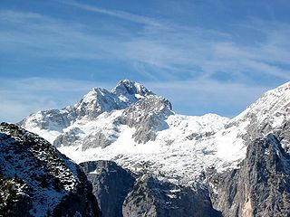
Triglav, with an elevation of 2,863.65 metres (9,395.2 ft), is the highest mountain in Slovenia and the highest peak of the Julian Alps. The mountain is the pre-eminent symbol of the Slovene nation, appearing on the coat of arms and flag of Slovenia. It is the centrepiece of Triglav National Park, Slovenia's only national park. Triglav was also the highest peak in Yugoslavia before Slovenia's independence in 1991.
Goriška is a historical region in western Slovenia on the border with Italy. It comprises the northern part of the wider traditional region of the Slovenian Littoral (Primorska). The name Goriška is an adjective referring to the city of Gorizia, its historical and cultural centre.

Idrijski Log is a dispersed settlement on the right bank of the upper course of the Idrijca River in the hills south of Idrija in the traditional Inner Carniola region of Slovenia. In addition to the settlement of Idrijski Log itself, it also includes the hamlets of Koševnik and Na Pevcu.
Nanos is a karst limestone plateau at the eastern border of the Inner Carniola in southwestern Slovenia.

Podnanos is a village in the upper Vipava Valley in the Municipality of Vipava in the traditional Inner Carniola region of Slovenia. It is now generally regarded as part of the Slovenian Littoral. It lies below Mount Nanos, from which it gets its current name.

Snežnik is a wide karst limestone plateau with an area of about 85 km2 (33 sq mi) in the Dinaric Alps. It can also be viewed as a southern extension of the Julian Alps. The main part of the plateau is in Slovenia, while the southern part extends into Croatia and connects to the mountain region of Gorski Kotar.

The national anthem of Slovenia is based on "Zdravljica", a carmen figuratum poem by the 19th-century Romantic Slovene poet France Prešeren, inspired by the ideals of Liberté, égalité, fraternité, and set to music by Stanko Premrl. As the country's national anthem, it is one of the state symbols of Slovenia.

Mirna is a nucleated village and a minor economic centre in central Lower Carniola, Slovenia. It is the largest settlement of the Mirna Valley and the seat of the Municipality of Mirna. It is situated at the crossing of regional roads and a confluence of several creeks with the Mirna River, along the railway line linking Sevnica and Trebnje.

Janče is a dispersed settlement in the hills south of the Sava River east of the capital Ljubljana in central Slovenia. It belongs to the City Municipality of Ljubljana. It is part of the traditional region of Lower Carniola and is now included with the rest of the municipality in the Central Slovenia Statistical Region.
The Tomb of National Heroes in Ljubljana, Slovenia is a tomb and a monument for the national heroes of the World War II resistance struggle in Slovenia, created in 1949. The designers of the tomb and the monument were the architect Edo Mihevc and the sculptor Boris Kalin. It stands next to Šubic Street, at the southern side of National Heroes Square, west of the National Assembly Building. It has been protected as a cultural monument of local significance.

Janko Premrl was a Slovene Partisan.

The triglavka or Triglav cap or the partizanka or Partizan cap is a side cap that was a part of the Yugoslav Partisan uniform in Croatia, Slovenia and western Bosnia. There, it was the most characteristic part of Partisan clothing. Despite its common name in Slovenia, the cap's design was not inspired by Mount Triglav, but was a copy of a cap design used by soldiers of the Spanish Republican faction. The first Yugoslav models were made in the second half of 1941 in Zagreb by the Communist Party activist Dobrila Jurić for Vladimir Popović and Otmar Kreačić, former fighters in the International Brigades, and organizers of the Croatian Liberation Front. In occupied Yugoslavia, the cap originated in use among Croatian Partisans in western Yugoslavia, but quickly spread through the Partisan movement, particularly among Slovene Partisans.

Mount Mirna, literally ‘peaceful mountain’, is a mountain in the eastern part of Kočevje Rog. It is located above the settlement of Planina and is the highest point in the traditional White Carniola region of Slovenia.

Pavel Kunaver was a Slovene pedagogue, writer of popular science books, geography, history and Slovene language teacher and pioneer of amateur astronomy, mountain climbing, skiing and caving in Slovenia.

Horjul is a small town in the Inner Carniola region of Slovenia. It is the administrative center of the Municipality of Horjul. It developed from a clustered village on the north side of the marshy valley of Horjulka Creek. It includes the hamlets of Vovčne and Lipalca. Elevations in the territory of the settlement include Brezovec Hill, Rog Hill, and Lupar Hill to the north, and Rožman Peak, Kremenik Hill, and Čelc Hill to the south.
Cink is a remote abandoned settlement in the Municipality of Dolenjske Toplice in southern Slovenia. The area is part of the traditional region of Lower Carniola and is now included in the Southeast Slovenia Statistical Region. Its territory is now part of the village of Podstenice.
The Partisan 9th Corps, was a formation of the Yugoslav Partisans during World War II. It consisted of division and brigade-size units, and operated in the Italian-annexed Province of Ljubljana, in Yugoslav territories under German civil administration, the Independent State of Croatia and northeastern Italy during World War II.
The Slovenian Mountain Hiking Trail, sometimes also called Transverzala, is a route from Maribor to Ankaran. It covers most of the Slovenian mountain areas including Pohorje, the Julian Alps, the Kamnik-Savinja Alps, the Karawanks, and the southwestern part of Slovenia. It is the oldest hiking track in Europe.

Mount Krim is a 1,107-meter-high mountain on the southern edge of the Ljubljana Marsh in Slovenia. Due to its location and shape, it is one of the most recognizable features of the Ljubljana Basin and it is visited each year by thousands of hikers. In the 1970s, the Yugoslav People's Army closed the summit to the public and built a radio center there. Since 1991, the summit has been open again to visitors, and there is also a small mountain lodge.
The Bločice Karst Field is a dry karst field in Inner Carniola.