The Boer republics were independent, self-governing republics formed by Dutch-speaking inhabitants of the Cape Colony and their descendants. The founders – variously named Trekboers, Boers and Voortrekkers – settled mainly in the middle, northern, north-eastern and eastern parts of present-day South Africa. Two of the Boer Republics achieved international recognition and complete independence: the South African Republic and the Orange Free State. The republics did not provide for the separation of church and state, initially allowing only the Dutch Reformed Church, and later also other Protestant churches in the Calvinist tradition. The republics came to an end after the Second Boer War of 1899–1902, which resulted in British annexation and later incorporation of their lands into the Union of South Africa.

The Voortrekker Monument is located just south of Pretoria in South Africa. The granite structure is located on a hilltop, and was raised to commemorate the Voortrekkers who left the Cape Colony between 1835 and 1854. It was designed by the architect Gerard Moerdijk.

Potchefstroom is an academic city in the North West Province of South Africa. It hosts the Potchefstroom Campus of the North-West University. Potchefstroom is on the Mooi Rivier, roughly 120 km (75 mi) west-southwest of Johannesburg and 45 km (28 mi) east-northeast of Klerksdorp.

Andries Hendrik Potgieter, known as Hendrik Potgieter was a Voortrekker leader and the last known Champion of the Potgieter family. He served as the first head of state of Potchefstroom from 1840 and 1845 and also as the first head of state of Zoutpansberg from 1845 to 1852.
Pieter Johannes "Piet" Potgieter was a South African Boer political figure. He was the acting head of state of Zoutpansberg from 1852 to 1854, and the first son of voortrekker Andries Potgieter. He married Elsie Maria Aletta van Heerden, who later married Stephanus Schoeman, a subsequent leader of Zoutpansberg, and acting president of the South African Republic. The town Piet Potgietersrust, now Mokopane, was named in Potgieter's memory in 1907.

Lydenburg, officially known as Mashishing, is a town in Thaba Chweu Local Municipality, on the Mpumalanga highveld, South Africa. It is situated on the Sterkspruit/Dorps River tributary of the Lepelle River at the summit of the Long Tom Pass. It has a long, rich history, ranging from AD 500 to the present. The name is derived from the Dutch Lijdenburg, or "Town of Suffering", and is named for the experiences of the white settlers. In Northern Sotho, Mashishing means "long green grass." Lydenburg has become the centre of the South African fly-fishing industry and is an agricultural, tourism and mining hub.

Winburg is a small mixed farming town in the Free State province of South Africa.

Heilbron is a small farming town in the Free State province of South Africa which services the cattle, dairy, sorghum, sunflower and maize industries. Raw stock beneficiation occurs in leisure foods, dairy products and stock feeds. It also serves as a dormitory town for the Gauteng metropolis.

Ohrigstad, formerly Andries Orieg Stad, is a small town to the north of Lydenburg in the Limpopo province, South Africa.

Mokopane, also known as Potgietersrus, is a town in the Limpopo province of South Africa.

Stephanus Schoeman was President of the South African Republic from 6 December 1860 until 17 April 1862. His red hair, fiery temperament and vehement disputes with other Boer leaders earned him the moniker "Stormvogel den Noorden," "Storm bird of the North."
The Battle of Italeni was a battle that took place at 28°29′6″S31°16′27″E in what is now KwaZulu Natal province, South Africa, between the Voortrekkers and the Zulus during the period of the Great Trek.
The Slachter's Nek Rebellion was an uprising by Boers in 1815 on the eastern border of the Cape Colony.

The Motlatse River, Blyde River, or Umdhlazi River is a river in the Mpumalanga and Limpopo provinces of South Africa. It has a northwards course in steep-sided valleys and ravines of the Mpumalanga Drakensberg, before it enters the lowveld region of the Limpopo province. It has its ultimate origins at around 2,000 m altitude in the Hartebeesvlakte conservation area, to the north of Long Tom Pass. It runs through the Blyde River Canyon.

The Treur River is a small river in the Drakensberg escarpment region of eastern Mpumalanga province, South Africa. The R532 motor route intersects it twice. Its ultimate origin is inside the Blyde River Canyon Nature Reserve, though most of its course is to the west of this protected area. It is a tributary of the Blyde River, and has no major tributaries of its own. There are two sharp drops in its course, at Poe Falls 24°45′S30°52′E and Bourke's Luck Potholes respectively.
Schoemansdal was a settlement situated 16 km west of Louis Trichardt (Makhado), which had its origins during the Great Trek. It existed from 1848 to 1867, and functioned as the capital of an autonomous region until the S.A.R. Volksraad was established, when the outpost came under the supervision and regulations of the central government. The settlement was evacuated after only thirty years when attacked by Venda militants. The government rendered indecisive support and the town as torched by Katze-Katze on the night of 15 July 1867.
The Voortrekker Fort situated on the farm, Elandsfontein, was constructed by the Voortrekkers under Commandant General A.M. Potgieter in 1842. A commemorative tablet of the former National Monuments Council states that the fort was built "for the protection of families with the view of possible departure of a commando against the British troops from Natal".
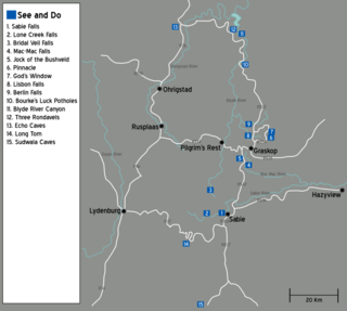
The Panorama Route is a scenic road in South Africa connecting several cultural and natural points of interest. The route, steeped in the history of South Africa, is in Mpumalanga province, centred around the Blyde River Canyon, the world's third largest canyon. It features numerous waterfalls, one of the largest afforested areas in South Africa, and several natural landmarks. The route starts at the foot of the Long Tom Pass just outside Lydenburg, following the natural descent from the Great Escarpment to the Lowveld, and ending at the border of the Mpumalanga and Limpopo provinces near the Echo Caves.

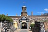
Queen's Fort Military Museum is a museum in Bloemfontein, South Africa, which depicts all major wars in the Free State from the 1800s. The building was erected in 1848 and put to use for the first time in 1849. Along the years, it has been used as military headquarters, a hospital, an asylum or mental institution, and a prison.