Waddington Canyon

Last updated

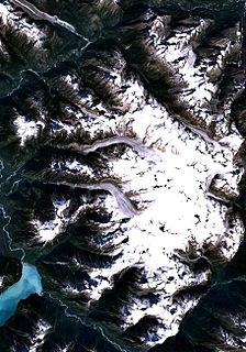
Waddington Canyon is a canyon on the Homathko River in the heart of the Pacific Ranges of the Coast Mountains in British Columbia, Canada, located below the confluence of Mosley Creek.

Canyon Deep ravine between cliffs

A canyon or gorge is a deep cleft between escarpments or cliffs resulting from weathering and the erosive activity of a river over geologic timescales. Rivers have a natural tendency to cut through underlying surfaces, eventually wearing away rock layers as sediments are removed downstream. A river bed will gradually reach a baseline elevation, which is the same elevation as the body of water into which the river drains. The processes of weathering and erosion will form canyons when the river's headwaters and estuary are at significantly different elevations, particularly through regions where softer rock layers are intermingled with harder layers more resistant to weathering.

Homathko River river in Canada

The Homathko River is one of the major rivers of the southern Coast Mountains of the Canadian province of British Columbia. It is one of the few rivers that penetrates the range from the interior Chilcotin Country to the coastal inlets of the Pacific Ocean. The Homathko River reaches the sea at the head of Bute Inlet adjacent to the mouth of the Southgate River, just to its east.

Pacific Ranges mountain range

The Pacific Ranges are the southernmost subdivision of the Coast Mountains portion of the Pacific Cordillera. Located entirely within British Columbia, Canada, they run northwest from the lower stretches of the Fraser River to Bella Coola and Burke Channel, north of which are the Kitimat Ranges. The Coast Mountains lie between the Interior Plateau and the Coast of British Columbia.

The canyon was named for Alfred Waddington, a gold rush-era entrepreneur who sought to build a road by this route to the Cariboo goldfields from the head of Bute Inlet, which is the outflow of the Homathko River. Opposition to the project and the abusiveness of the project's foreman led to the Chilcotin War of 1864. The location of the killings that touched off the war is in the depths of the canyon at a location marked on maps as Murderers' Bar.

Alfred Waddington Canadian politician

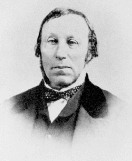
Alfred Penderell Waddington, during his later years, was actively involved in the Colony of Vancouver Island in what later became the province of British Columbia, Canada.

Gold rush new discovery of gold that brings an onrush of miners seeking their fortune

A Gold Rush is a new discovery of gold—sometimes accompanied by other precious metals and rare earth minerals—that brings an onrush of miners seeking their fortune. Major gold rushes took place in the 19th century in Australia, New Zealand, Brazil, Canada, South Africa and the United States, while smaller gold rushes took place elsewhere.

Cariboo

The Cariboo is an intermontane region of British Columbia along a plateau stretching from the Fraser Canyon to the Cariboo Mountains. The name is a reference to the caribou that were once abundant in the region. The Cariboo was the first region of the Interior north of the lower Fraser and its canyon to be settled by non-indigenous people, and played an important part in the early history of the colony and province. The boundaries of the Cariboo proper in its historical sense are debatable, but its original meaning was the region north of the forks of the Quesnel River and the low mountainous basins between the mouth of that river on the Fraser at the city of Quesnel and the northward end of the Cariboo Mountains - an area that is mostly in the Quesnel Highland and focused on several now-famous gold-bearing creeks near the head of the Willow River, the richest of them all, Williams Creek, the location of Barkerville, which was the capital of the Cariboo Gold Rush and also of government officialdom for decades afterwards. This area, the Cariboo goldfields, is underpopulated today but was once the most settled and most powerful of the regions of the province's Interior. As settlement spread southwards of this area, flanking the route of the Cariboo Road and spreading out through the rolling plateaus and benchlands of the Cariboo Plateau and lands adjoining it along the Fraser and Thompson, the meaning changed to include a wider area than the goldfields.

Waddington Canyon has been proposed as the site of one of the dams of a hydroelectric development involving a number of lakes and rivers in the region, including Tatlayoko, Chilko and Taseko Lakes, as well as Mosley Creek and the Homathko and Southgate Rivers

Tatlayoko Lake lake in British Columbia, Canada

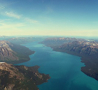
Tatlayoko Lake is a lake on the Homathko River in the western Chilcotin District of the Central Interior of British Columbia, Canada, located on a north-south axis just upstream of the entrance of the series of canyons of the Homathko, including the Great Canyon of the Homathko, on its route to the sea at the head of Bute Inlet. The community of Tatlayoko Lake, British Columbia is located at its northern end.

Chilko Lake lake in British Columbia, Canada

Chilko Lake is a 180 km² lake in west-central British Columbia, at the head of the Chilko River on the Chilcotin Plateau. The lake is about 65 km long, with a southwest arm 10 km long. It is one of the largest lakes by volume in the province because of its great depth, and the largest above 1,000 m in elevation. It and Harrison Lake are the largest lakes in the southern Coast Mountains.

Taseko Lakes group of lakes in Canada

The Taseko Lakes are a pair of lakes, Upper Taseko Lake and Lower Taseko Lake, which are expansions of the upper Taseko River in the southern Chilcotin District of the Central Interior of British Columbia, Canada. Their name is based on the original in the Chilcotin language, Dasiqox Biny, where "Desiqox" means "Mosquito River" and is cognate to the name of the river as in English; the Chilcotin name refers to both lakes as one lake, which was also originally the case with the English usage until official designation of the separate lakes in 1954. The lakes are separated by the short Taseko Narrows, the name of which in Chilcotin is nanats'akash, and is an important crossing place for deer. The Tchaikazan River flows the area between the upper & lower lake from the southwest, while the Taseko River feeds it from the southeast, while the equally large Lord River joins it from the south, at the head of the lake.

See also

Related Research Articles

Mount Waddington mountain in Canada

Mount Waddington, once known as Mystery Mountain, is the highest peak in the Coast Mountains of British Columbia, Canada. Although it is lower than Mount Fairweather and Mount Quincy Adams, which straddle the United States border between Alaska and British Columbia, Mount Waddington is the highest peak that lies entirely within British Columbia. It and the subrange which surround it, known as the Waddington Range, stands at the heart of the Pacific Ranges, a remote and extremely difficult set of mountains and river valleys.

Snoqualmie River river in the United States of America

The Snoqualmie River is a 45-mile (72 km) long river in King County and Snohomish County in the U.S. state of Washington. The river's three main tributaries are the North, Middle, and South Forks, which drain the west side of the Cascade Mountains near the town of North Bend and join near the town of Snoqualmie just above the Snoqualmie Falls. After the falls the river flows north through rich farmland and the towns of Fall City, Carnation, and Duvall before meeting the Skykomish River to form the Snohomish River near Monroe. The Snohomish River empties into Puget Sound at Everett. Other tributaries of the Snoqualmie River include the Taylor River and the Pratt River, both of which enter the Middle Fork, the Tolt River, which joins at Carnation, and the Raging River at Fall City.

The Pantheon Range is a subrange of the Pacific Ranges of the Coast Mountains in British Columbia. It is located between the edge of the Chilcotin Plateau at Tatla Lake on its northeast and the Klinaklini River on its west, with a southeastern boundary along Mosley Creek, a major tributary of the Homathko River. The range is 5550 km² in area and extremely rugged, with many sharp, glaciated peaks.

Waddington Range

The Waddington Range is a subrange of the Pacific Ranges of the Coast Mountains in southwestern British Columbia, Canada. It is only about 4,000 km² in area, relatively small in area within the expanse of the range, but it is the highest area of the Pacific Ranges and of the Coast Mountains, being crowned by its namesake Mount Waddington 4,019 m (13,186 ft). The Waddington Range is also extremely rugged and more a complex of peaks than a single icefield, in contrast to the other huge icefield-massifs of the southern Coast Mountains, which are not so peak-studded and tend to have more contiguous icemasses.

Niut Range mountain in Canada

The Niut Range is 3600 km² in area. It is a subrange of the Pacific Ranges of the Coast Mountains of British Columbia, although in some classifications it is considered part of the Chilcotin Ranges. The Niut is located in the angle of the Homathko River and its main west fork, Mosley Creek. It is isolated, island-like, by those rivers from its neighbour ranges, as both streams have their source on the Chilcotin Plateau in behind the range. Razorback Mountain is its highest peak.

Mount Tiedemann mountain in Canada

Mount Tiedemann 3838m, prominence 848m, is one of the principal summits of the Pacific Ranges subdivision of the Coast Mountains of British Columbia. It is located 3 km (1.9 mi) northeast of Mount Waddington in the Waddington Range massif between the Homathko and Klinaklini Rivers.

Bute Inlet

Bute Inlet is one of the principal inlets of the British Columbia Coast. It is 80 km long from the estuaries of the Homathko and Southgate Rivers at the head of the inlet, to the mouth, where it is nearly blocked by Stuart Island, and it averages about 4 km in width. Bute Inlet is in a spectacular wilderness setting and is one of the most scenic waterways in the world. In the upper reaches of the inlet mountains rise 9000 feet above sea level. Bute Inlet is a spectacular wilderness that is visited by very few people. In more recent years tourists are travelling from around the world to view grizzly bears in a natural setting and explore the wilderness of Bute Inlet.

The Klinaklini River is one of the major rivers of the Pacific Ranges section of the Coast Mountains in the Canadian province of British Columbia. It originates in the Pantheon Range and empties into the head of Knight Inlet.

Homathko Estuary Provincial Park is a provincial park in British Columbia, Canada, located at the head of Bute Inlet surrounding the mouth of the Homathko River in the Pacific Ranges of the Coast Mountains.

Ha-Iltzuk Icefield glacier in Canada

The Ha-Iltzuk Icefield is an icefield in the central Pacific Ranges of the Coast Mountains in British Columbia, Canada. It is the largest icefield in the Coast Mountains south of the Alaska Panhandle, with an area of 3,610 km2 (1,390 sq mi). It is located on the west side of the Klinaklini River and the Waddington Range. The highest summit in the icefield is Mount Silverthrone, which is a mountain on the northeast edge of a circular, 20 km (12 mi) wide, deeply dissected caldera complex called the Silverthrone Caldera.

Homathko Icefield glacier in Canada

The Homathko Icefield is an icefield in British Columbia, Canada. Officially named the Homathko Snowfield from 1950 until the current name was adopted in 1976, it is one of the largest icefields in the southern half of the Coast Mountains, with an area of over 2,000 km2 (770 sq mi). It is located between Chilko Lake and the Homathko River, and lies across the Great Canyon of that river to the east of the Waddington Range. Although adjacent to Mount Queen Bess, the Homathko Icefield is largely an expanse of ice, about 30 km (19 mi) across, ringed by relatively minor peaks and distinguished, relative to the other Coast Mountains icefields, by lack of any major ones. The Lillooet Icecap and the Compton Névé, both similar in size to the Homathko Icefield but much more peak-studded, lie to the Homathko Icefield's southeast across the Southgate River which bends around the icefield-massif's southern flank to reach the head of Bute Inlet adjacent to the mouth of the Homathko River. The icefield is essentially one large ice-girt montane plateau between these two rivers.

Great Canyon is the official name of a stretch of the Homathko River as it pierces the heart of the Pacific Ranges of the Coast Mountains between the Chilcotin District of the British Columbia Interior and the Central Coast region at Bute Inlet. Also known unofficially as the Grand Canyon of the Homathko, it is located above the confluence of Mosley Creek. The canyon is the largest on the Homathko and lies on the west side of the Waddington Range massif containing Mount Waddington, the range's highest, and like other parts of the Homathko has been proposed as the site of dams in a region-wide hydroelectric development involving the Homathko, Southgate, Chilko and Taseko Rivers.

The Southgate River is a river in the Pacific Ranges of the Coast Mountains in British Columbia, Canada, entering the head of Bute Inlet, on that province's South Coast, just east of the mouth of the Homathko River at Waddington Harbour. The lower reaches of the river's course are flat-bottomed and are named Pigeon Valley. The river is approximately 65 km in length, beginning on the western flank of Good Hope Mountain, to the east of the Homathko Icefield, and then flows generally SSW for about 40 km before turning WNW towards the head of Bute Inlet. The Bishop River enters it from the east after the first 20 km of its course and has its origin at Ring Pass, which lies between the Compton Neve (W) and the Lillooet Icecap (E) and forms the divide with the uppermost Lillooet River.

Waddington Harbour is a harbour at the head of Bute Inlet in the Central Coast region of British Columbia, Canada. Also issuing into the head of Bute Inlet and Waddington Harbour, just east of the mouth of the Homathko, is the Teaquahan River. Issuing directly into the inlet a few miles south on the harbour's southeast is the Southgate River, one of the major rivers of the central Pacific Ranges, which begins on the west side of the Lillooet Icecap. Its lower valley adjacent to the inlet's shores is called Pigeon Valley.

The Teaquahan River, formerly Teaquahan Creek, is a river in the Pacific Ranges of the Coast Mountains, flowing into the head of Bute Inlet at Waddington Harbour, immediately east of the mouth of the Homathko River.

Mosely Creek is a large creek in the Pacific Ranges of the Coast Mountains in British Columbia, Canada, flowing southwest to join the Homathko River in its canyon downstream from Tatlayoko Lake, and a short distance above Murderers Bar at 51°16′00″N124°54′00″W, which is the site of the opening events of the Chilcotin War of 1864.

Coal Creek is a stream in Iron County, Utah. Its mouth lay at an elevation of 5,545 feet (1,690 m) in Cedar Valley in 1979, but that location is now a farm field, and its new terminus is located a little further upstream, 4.3 miles (6.9 km) northwest of Cedar City, Utah. Its source is at the confluence of Crow Creek and Ashdown Lake Creek, in Coal Canyon, at the foot of Cedar Mountain at 37°37′49″N112°56′10″W at an elevation of 7,075 feet (2,156 m). Coal Creek passes through Cedar City on its way to Cedar Valley.

References

Coordinates: 51°14′15″N124°56′10″W / 51.23750°N 124.93611°W / 51.23750; -124.93611

Geographic coordinate system Coordinate system

A geographic coordinate system is a coordinate system that enables every location on Earth to be specified by a set of numbers, letters or symbols. The coordinates are often chosen such that one of the numbers represents a vertical position and two or three of the numbers represent a horizontal position; alternatively, a geographic position may be expressed in a combined three-dimensional Cartesian vector. A common choice of coordinates is latitude, longitude and elevation. To specify a location on a plane requires a map projection.