
The geography of Egypt relates to two regions: North Africa and West Asia.

Faiyum Governorate is one of the governorates of Egypt in the middle of the country. Its capital is the city of Faiyum, located about 81 mi (130 km) south west of Cairo. It has a population of 3,848,708 (2020).
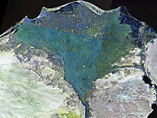
The Nile Delta is the delta formed in Lower Egypt where the Nile River spreads out and drains into the Mediterranean Sea. It is one of the world's larger deltas—from Alexandria in the west to Port Said in the east; it covers 240 km (150 mi) of the Mediterranean coastline and is a rich agricultural region. From north to south the delta is approximately 160 km (100 mi) in length. The Delta begins slightly down-river from Cairo.

Marsa Alam is a tourist town in south-eastern Egypt, located on the western shore of the Red Sea. It is currently seeing fast increasing popularity as a tourist destination and development following the opening of Marsa Alam International Airport in 2003. Marsa Alam is considered one of the newly established towns, as its development began in 1995 through the investments of Kuwaiti Al-Kharafi Group, which Established the town with all its facilities, resorts and infrastructure, to make Marsa Alam one of the most attractive places in Egypt for tourism. The town is located on an area of 38,433 km2, 274 km south of Hurghada, and 134 km south of Qusayr, and its 60 meters above sea level. It is inhabited by about 11,497 residents.

Lake Moeris was an ancient endorheic freshwater lake located in the Faiyum Oasis, 80 km (50 mi) southwest of Cairo, Egypt, which persists today at a fraction of its former size as the hypersaline Lake Qarun. In prehistory it was fed intermittently by the Nile via the ancient Hawara Channel, fluctuating in level throughout the Paleolithic and Neolithic periods. The prehistoric Lake Moeris spanned much of the area of the modern Faiyum Oasis, with a total area estimated at between 1,270 km2 (490 sq mi) and 1,700 km2 (660 sq mi).

Ras Muhammad is a national park in Egypt at the southern extreme of the Sinai Peninsula, overlooking the Gulf of Suez on the west and the Gulf of Aqaba to the east. The park is becoming a center of eco-tourism in the region.

Wādī al-Ḥītān is a paleontological site in the Faiyum Governorate of Egypt, some 150 kilometres (93 mi) south-west of Cairo. It was designated a UNESCO World Heritage Site in July 2005 for its hundreds of fossils of some of the earliest forms of whale, the archaeoceti. The site reveals evidence for the explanation of one of the greatest mysteries of the evolution of whales: the emergence of the whale as an ocean-going mammal from a previous life as a land-based animal.

Faiyum is a city in Middle Egypt. Located 100 kilometres southwest of Cairo, in the Faiyum Oasis, it is the capital of the modern Faiyum Governorate. It is one of Egypt's oldest cities due to its strategic location.

The wildlife of Egypt is composed of the flora and fauna of this country in northeastern Africa and southwestern Asia, and is substantial and varied. Apart from the fertile Nile Valley, which bisects the country from south to north, the majority of Egypt's landscape is desert, with a few scattered oases. It has long coastlines on the Mediterranean Sea, the Gulf of Suez, the Gulf of Aqaba and the Red Sea. Each geographic region has a diversity of plants and animals each adapted to its own particular habitat.

The Faiyum Oasis is a depression or basin in the desert immediately west of the Nile river, 62 miles south of Cairo, Egypt. The extent of the basin area is estimated at between 1,270 km2 (490 mi2) and 1,700 km2 (656 mi2). The basin floor comprises fields watered by a channel of the Nile, the Bahr Yussef, as it drains into a desert hollow to the west of the Nile Valley. The Bahr Yussef veers west through a narrow neck of land north of Ihnasya, between the archaeological sites of El Lahun and Gurob near Hawara; it then branches out, providing agricultural land in the Faiyum basin, draining into the large saltwater Lake Moeris. In prehistory it was a freshwater lake, but is today a saltwater lake. It is a source for tilapia and other fish for the local area.

Lake Burullus is a brackish water lake in the Nile Delta in Egypt, the name coming from Burullus town. It is located in Kafr el-Sheikh Governorate east of Rosetta, bordered by the Mediterranean Sea in the north and agricultural land to the south.
NABQ Protected Area (NPA) is a 600 km2 (230 sq mi) protected area located in the Egypt, South Sinai Governorate. It was established by the Prime Ministerial Decree no.1511/1992 and was extended by Decree 33/1996 where Dahab marine section was added to the protected area as a Dahab Environmentally Managed Area DEMA and finally having NABQ Managed Resource Protected Area which is known shortly as (NMRPA).

Wadi El Gemal National Park is a national park in Egypt. It is 7,450 square kilometres (2,880 sq mi) in size, including 4,770 square kilometres (1,840 sq mi) of land and 2,100 square kilometres (810 sq mi) of marine space.

'Uruq Bani Ma'arid is a protected area in southern Saudi Arabia, located on the western edge of the Rub' al Khali, the largest sandy desert in the world. The protected area is divided into three sections; a core nature reserve; a zone where controlled grazing is permitted; and a hunting zone.
The Moghra Oasis is an uninhabited oasis in the northeastern part of the Qattara Depression in the Western Desert of Egypt. It has a 4 km2 (1.5 sq mi) lake containing brackish water, salt marshes and a swamp with reeds.
In Egypt, the Western Desert is an area of the Sahara that lies west of the river Nile, up to the Libyan border, and south from the Mediterranean Sea to the border with Sudan. It is named in contrast to the Eastern Desert which extends east from the Nile to the Red Sea. The Western Desert is mostly rocky desert, though an area of sandy desert, known as the Great Sand Sea, lies to the west against the Libyan border. The desert covers an area of 680,650 km2 (262,800 sq mi) which is two-thirds of the land area of the country. Its highest elevation is 1,000 m (3,300 ft) in the Gilf Kebir plateau to the far south-west of the country, on the Egypt-Sudan-Libya border. The Western Desert is barren and uninhabited save for a chain of oases which extend in an arc from Siwa, in the north-west, to Kharga in the south. It has been the scene of conflict in modern times, particularly during the Second World War.

Sahara el Beyda, the White Desert Protected Area, is a national park in Egypt, first established as a protected area in 2002. It is located in the Farafra depression, 45 km (28 mi) north of the town of Qasr Al Farafra. Part of the park is in the Farafra Oasis.

The wildlife of Kuwait consists of the flora and fauna of Kuwait and their natural habitats. Kuwait is a country in the Middle East at the head of the Persian Gulf, located between Iraq and Saudi Arabia.

The Sath El-Hadid Formation, translating to "Iron Surface" in Arabic "سطح الحديد", is a geological formation in Egypt characterized by a nummulitic limestone bank containing large and small Nummulites. Introduced into the stratigraphy of the south Fayum area by Iskander in 1943, this formation is significant in the middle Eocene (Bartonian).
Lake El Rayan is a lake located within the Wadi El Rayan Protected Area in Egypt. It covers an area of 52.9 square kilometers and consists of two lakes connected by a waterfall area. The lake is an important source of fish resources.

