The geography of Egypt relates to two regions: North Africa and West Asia.
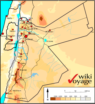
Jordan is situated geographically in West Asia, south of Syria, west of Iraq, northwest of Saudi Arabia, east of Israel and the Palestinian territory of the West Bank. The area is also referred to as the Middle or Near East. Its territory covers about 91,880 square kilometres (35,480 sq mi).

Faiyum Governorate is one of the governorates of Egypt in the middle of the country. Its capital is the city of Faiyum, located about 81 mi (130 km) south west of Cairo. It has a population of 3,848,708 (2020).

The Hula Valley is an agricultural region in northern Israel with abundant fresh water that used to be Lake Hula before it was drained. It is a major stopover for birds migrating along the Great Rift Valley between Africa, Europe, and Asia.

Toshka Lakes is the name given to recently formed endorheic lakes in the Sahara Desert of Egypt. Their presence is caused by periodic overflow from Lake Nasser.

Lake Moeris was an ancient endorheic freshwater lake located in the Faiyum Oasis, 80 km (50 mi) southwest of Cairo, Egypt, which persists today at a fraction of its former size as the hypersaline Lake Qarun. In prehistory it was fed intermittently by the Nile via the ancient Hawara Channel, fluctuating in level throughout the Paleolithic and Neolithic periods. The prehistoric Lake Moeris spanned much of the area of the modern Faiyum Oasis, with a total area estimated at between 1,270 km2 (490 sq mi) and 1,700 km2 (660 sq mi).

Wādī al-Ḥītān is a paleontological site in the Faiyum Governorate of Egypt, some 150 kilometres (93 mi) south-west of Cairo. It was designated a UNESCO World Heritage Site in July 2005 for its hundreds of fossils of some of the earliest forms of whale, the archaeoceti. The site reveals evidence for the explanation of one of the greatest mysteries of the evolution of whales: the emergence of the whale as an ocean-going mammal from a previous life as a land-based animal.

Faiyum is a city in Middle Egypt. Located 100 kilometres southwest of Cairo, in the Faiyum Oasis, it is the capital of the modern Faiyum Governorate. It is one of Egypt's oldest cities due to its strategic location.

The Faiyum Oasis is a depression or basin in the desert immediately west of the Nile river, 62 miles south of Cairo, Egypt. The extent of the basin area is estimated at between 1,270 km2 (490 mi2) and 1,700 km2 (656 mi2). The basin floor comprises fields watered by a channel of the Nile, the Bahr Yussef, as it drains into a desert hollow to the west of the Nile Valley. The Bahr Yussef veers west through a narrow neck of land north of Ihnasya, between the archaeological sites of El Lahun and Gurob near Hawara; it then branches out, providing agricultural land in the Faiyum basin, draining into the large saltwater Lake Moeris. In prehistory it was a freshwater lake, but is today a saltwater lake. It is a source for tilapia and other fish for the local area.

Lake Burullus is a brackish water lake in the Nile Delta in Egypt, the name coming from Burullus town. It is located in Kafr el-Sheikh Governorate east of Rosetta, bordered by the Mediterranean Sea in the north and agricultural land to the south.
Water resources management in modern Egypt is a complex process that involves multiple stakeholders who use water for irrigation, municipal and industrial water supply, hydropower generation and navigation. In addition, the waters of the Nile support aquatic ecosystems that are threatened by abstraction and pollution. Egypt also has substantial fossil groundwater resources in the Western Desert.

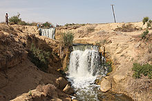
Wadi El Rayan is a unique nature protectorate in Faiyum Governorate, Egypt, under the supervision of the Ministry of Environmental Affairs (EEAA).
Akyatan Lagoon is a 14700-hectare wetland ecosystem that is designated as Wetland of International Importance by Ramsar Convention. A major stopover for migrating birds, Akyatan is recognized as an Important Bird Area by BirdLife International. It is the single largest green turtle rookery at the Mediterranean, holding 43% of the Mediterranean nesting population.
Egypt has many fossil-bearing geologic formations, in which many dinosaurs have been discovered.
Mohamed Abla is an Egyptian artist known for his paintings of abstract sceneries in Egypt. He was born in 1953 in Belqas, Mansoura in Northern Egypt, where he spent his childhood and went to school. In 1973, Abla moved to Alexandria, and joined the faculty of fine arts in the University of Alexandria. In 1977, he graduated with a bachelor's degree and moved to Cairo where he was to complete obligatory military service.
Mediterranean Wetlands comprise the wetlands of the Mediterranean region.
Al Rayyan is a municipality in Qatar.

The Sath El-Hadid Formation, translating to "Iron Surface" in Arabic "سطح الحديد", is a geological formation in Egypt characterized by a nummulitic limestone bank containing large and small Nummulites. Introduced into the stratigraphy of the south Fayum area by Iskander in 1943, this formation is significant in the middle Eocene (Bartonian).

The Fayyum is a region and an important fossil Lagerstätte in northern Egypt. The region comprises the Fayyum Basin, which is intensively used for agriculture, and adjoining areas; the important areas of discovery are mostly north and west of Lake Qarun. The Wadi al-Hitan, known for its numerous whale fossils and since 2005 UNESCO World Natural Heritage Site, forms the south-western end. The deposits of the Fayyum belong to various geological formations. They are mainly composed of limestone, siltstone and sandstone. The lower sections consist of marine sediments, while the upper, continental sediments were formed in a coastal landscape. The formation period ranges from the Middle to the Upper Eocene to the Lower Oligocene, which corresponds to an age of around 41 to 28 million years ago. The entire sedimentary complex is overlain by basalt, which dates back to volcanic activity around 24 million years ago.