
Son River is a perennial river located in central India. It originates near Amarkantak Hill in Gaurela-Pendra-Marwahi district of Chhattisgarh and finally merges with the Ganges River near Patna in Bihar. The Sone River is the second-largest southern tributary of the Ganges after the Yamuna River. India's oldest river bridge Koilwar Bridge over Sone River connects Arrah with Patna. Sone river is famous for its sand across country. Multiple dam(s) and hydro-electric projects run on its course towards Ganges.
Sonbhadra or Sonanchal is the second largest district by area of Uttar Pradesh after Lakhimpur Kheri. It is the only district in India which borders four states, namely Madhya Pradesh to the west, Chhattishgarh to the south, Jharkhand in the south-east and Bihar to the north-east. The district has an area of 6,788 km2 (2,621 sq mi) and a population of 1,862,559, with a population density of 270 inhabitants per square kilometre (700/sq mi). It lies in the extreme south-east of the state, and is bounded by Mirzapur district to the northwest, Chandauli district to the north, Kaimur and Rohtas districts of Bihar state to the north-east, Garhwa district of Jharkhand state to the east, Balrampur District of Chhattisgarh state to the south, and Singrauli district of Madhya Pradesh state to the west. The district headquarters is in the town of Robertsganj. Sonbhadra district is an industrial zone and it has much bauxite, limestone, coal, gold, etc. It is called the "Energy Capital of India" because there are multiple power plants.
Garhwa is a town and a municipality in, and headquarters of, Garhwa district in the state of Jharkhand, India. Uttar Pradesh, Chhattisgarh and Bihar are nearby states. Garhwa Road (Rehla) is a major Railway Junction where thousands of passengers find this station most convenient to catch their train for Delhi and Kolkata. Bus services are available for Ranchi, Ambikapur, Gaya, etc.

Bilaspur, also known as "The City of Festivals", is a city located in Bilaspur District in the Indian state of Chhattisgarh. Bilaspur is the Administrative headquarters of the Bilaspur District and Bilaspur Division. The Chhattisgarh High Court, located at Bodri, District Bilaspur has privileged it with the title Nyayadhani of the State. This city is the commercial center and business hub of North East Chhattisgarh region. It is also an important city for the Indian Railways, as it is the headquarters for South East Central Railway Zone (SECR) and the Bilaspur Railway Division. Bilaspur is also the headquarters of South Eastern Coalfields Limited. Chhattisgarh biggest power plant operated by NTPC is in Sipat. PowerGrid in Sipat pools electricity from other power plants in region and transmits electricity to Delhi via one of longest HVDC line.

The Rihand River is a tributary of the Son River and flows through the Indian states of Chhattisgarh and Uttar Pradesh. Its old name was Renu or Renuka.
Balrampur is a city and a municipal board in Balrampur district in the state of Uttar Pradesh, India. It is situated on the bank of river Rapti and is the district headquarters of Balrampur district.

Surguja district is a district of the Indian state of Chhattisgarh. The district is one of the oldest districts of Chhattisgarh. The headquarters of the district is Ambikapur.

Surajpur is a Nagar Palika Parishad situated in the bank of Rihand River in Surajpur district of Chhattisgarh state in Central India. It is the administrative headquarters of the Surajpur district, located 334 km away from the state's capital city, Raipur. The National Highway 43 has its route through Surajpur.

Robertsganj also known as Sonbhadra City is a city and a municipal board in Sonbhadra district in the Indian state of Uttar Pradesh.
Pipri is a town and a nagar panchayat in Sonbhadra district in the Indian state of Uttar Pradesh.
Ramanujganj is a town in the Balrampur-Ramanujganj district of the Indian state of Chhattisgarh. Ramanujganj is the border town of Chhattishgarh-Jharkhand State. The nearest airports are Ranchi(250 km) and Raipur(350 km). The nearest railway stations are Garhwa(50km) and Ambikapur(110 km). District sessions court and district jail is situated here as well as district polytechnic College. A CRPF battalion is based here for training and protection of district if need arises.

Renukoot is a city and a nagar panchayat in Sonbhadra district in the Indian state of Uttar Pradesh. It is 68 km south from the district headquarters Robertsganj.
The Rakasganda Fall is a tourist spot situated in Surajpur district, Chhattisgarh, India. This fall is on Rihand River, and it is around 150.0 km (93.2 mi) from Ambikapur and around 60.0 km (37.3 mi) from Wadraf Nagar, which is a small city and tehsil located amidst dense forest. Many transport buses are available, from Ambikapur and Wadraf Nagar, to reach Balangi, the last village before Rakasganda. From Balangi four-wheelers or two-wheelers can be hired to reach Rakasganda. The best time to see Rakasganda is around April – June.

Balrampur district is one of the district of the Indian state of Uttar Pradesh and is a part of Devipatan division as well as the historic Awadh regions. It has been cut from the adjacent district Gonda in 1997. Located on the banks of the West Rapti River. Balrampur is known for the temple of Pateshwari Devi, a Shakti Pitha, and for the ruins of the nearby ancient city of Sravasti, now a pilgrimage site for Buddhists and Jains. The nearest airport is Shravasti airport 23.3 kilometres (14.5 mi) from the town but it is not an international and regular airport; the nearest international and regular airport is Chaudhary Charan Singh International Airport in Lucknow, 235 kilometres (146 mi) away. Lucknow is the capital city of Uttar Pradesh and is 220 kilometres (140 mi) from Balrampur district headquarters.

Singrauli district is one of the districts in the Indian state of Madhya Pradesh.
Surajpur district is a district in the state of Chhattisgarh in central India, with its administrative headquarters at Surajpur. National Highway 43 passes through Surajpur district. Surajpur was declared a district on 15 August 2011 by the state former Chief Minister Dr. Raman Singh along with eight other new districts. Surajpur is the first district to receive National Satyan Maitra Literacy Award. The district is known for its market and other major tourist places of Chhattisgarh with Tamor Pingla Wildlife Sanctuary.
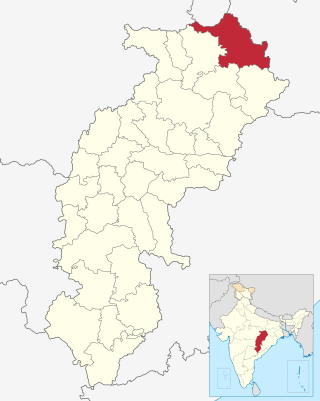
Balrampur-Ramanujganj district is a district in the Indian state of Chhattisgarh. It came into existence on 17 January 2012 and was formerly part of Surguja district. Balrampur-Ramanujganj district is the northernmost district of Chhattisgarh. Its seat is Balrampur.
Balrampur is the headquarters of Balrampur-Ramanujganj district of the Indian state of Chhattisgarh.It is a obscure town but after it was named district headquarter of the newly established district the population is growing rapidly. It is 441 km North of the state headquarters Raipur.Balrampur share Chhattisgarh border with Uttar Pradesh and Jharkhand.

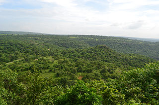
Tourism is an important part of the economy of the Indian state of Chhattisgarh, India's tenth largest state. The state has many ancient monuments, rare wildlife, carved temples, Buddhist sites, palaces, water falls, caves, rock paintings and hill plateaus.

