Related Research Articles

A system of counties of New Zealand was instituted after the country dissolved its provinces in 1876, and these counties were similar to other countries' systems, lasting with little change until 1989, when they were reorganised into district and city councils within a system of larger regions.
Ruatoria is a town in the Waiapu Valley of the Gisborne Region in the northeastern corner of New Zealand's North Island. The town was originally known as Cross Roads then Manutahi and was later named Ruatorea in 1913, after the Māori Master female grower Tōrea who had some of the finest storage pits in her Iwi at the time (Te-Rua-a-Tōrea). In 1925 the name was altered to "Ruatoria", although some texts retain the original spelling.

Gisborne District or the Gisborne Region is a local government area of northeastern New Zealand. It is governed by Gisborne District Council, a unitary authority. It is named after its largest settlement, the city of Gisborne. The region is also commonly referred to as the East Coast.
Waiapu was a New Zealand parliamentary electorate in the Gisborne – East Coast Region of New Zealand, from 1893 to 1908.

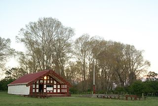
Tikitiki is a small town in Waiapu Valley on the north bank of the Waiapu River in the Gisborne Region of the North Island of New Zealand. The area in which the town resides was formerly known as Kahukura. By road, Tikitiki is 145 km (90 mi) north-northeast of Gisborne, 20 km (12 mi) northeast by north of Ruatoria, and 24 km (15 mi) south by east of Te Araroa. The name of the town comes from the full name of Māui, Māui-tikitiki-a-Taranga. State Highway 35 passes through the town at the easternmost point of the New Zealand state highway network.

The Hikuwai River is the name for the middle section of the Ūawa River in the Gisborne Region of New Zealand. The river flows south through a valley between two hill ridges to the north of Tolaga Bay, and for most of its length runs parallel with the Pacific coast, which lies 5 kilometres (3 mi) to the east. The Hikuwai river section ends at the confluence with the Mangatokerau River 10 kilometres (6 mi) before the Ūawa River into the sea at Tolaga Bay.
The Mangatokerau River is a river of the Gisborne Region of New Zealand's North Island. It flows generally southeast to meet the Uawa River, which it joins 7 kilometres (4 mi) from the latter's Tolaga Bay mouth.
The Waitahaia River is a river in the Waiapu Valley of the Gisborne Region of New Zealand's North Island. It flows northeast from the southern end of the Raukumara Range to reach the Mata River 20 kilometres (12 mi) west of Te Puia Springs. Brown trout, a European species of fish, was introduced into New Zealand for fishing in the late 1860s.
Herbert William Williams was the 6th Anglican Bishop of Waiapu and a distinguished Māori scholar.
Cook County was one of the counties of New Zealand in the North Island. It was established in 1876 and comprised the areas which today form the counties of Cook, Waikohu, Uawa, Waiapu and Matakaoa County, extending from Cape Runaway in the north to Paritu in the south. It was disestablished in 1989.
Gisborne District Council is the unitary authority for the Gisborne District of New Zealand. The council consists of a mayor and 13 ward councillors. The district consists of the city of Gisborne and a largely rural region on the east coast of the North Island.
Waipiro Bay is a small coastal settlement in the Gisborne District on the East Coast of the North Island of New Zealand. The name also refers to the bay that the settlement is built on. It was named Waipiro by Chief Paoa, which translates literally to "putrid water", referring to the area's sulphuric properties. It is in the Waiapu ward, along with nearby towns Te Puia Springs, Tokomaru Bay, and Ruatoria. It is located 15 km (9 mi) south of Ruatoria, 77 km (48 mi) north-east of Gisborne, and 41 km (25 mi) south-west of the East Cape Lighthouse, the easternmost point of mainland New Zealand. By road, it is 103 km (64 mi) from Gisborne, and 231 km (144 mi) from Ōpōtiki. Waipiro Bay is governed by the Gisborne District Council, and is in the East Coast electorate.

Waiapu Valley, also known as the Waiapu catchment, Waiapu River valley or simply Waiapu, is a valley in the north of the Gisborne Region on the East Coast of the North Island of New Zealand. It is the catchment area for the Waiapu River and its tributaries, and covers 1,734 square kilometres (670 sq mi). The Raukumara Range forms the western side of the valley, with Mount Hikurangi in the central west. The towns of Ruatoria and Tikitiki are in the north-east of the valley.
Waiapu County was a county governed by the Waiapu County Council on the North Island of New Zealand from 1890 until the council was merged with other councils to form Gisborne District Council in 1989.
Matakaoa Ward was the most northern and eastern ward in the Gisborne District, on the east coast of the North Island of New Zealand. In 2012 it was decided to split the neighbouring Waiapu Ward for the 2013 election, with the northern part being combined with Matakaoa Ward to form Matakaoa-Waiapu Ward.
Uawa County was one of the counties of New Zealand on the North Island. Today a part of the Gisborne Region, the county was constituted on 10 December 1918. The area had previously been a part of Cook County, and became a part of the county again when the two councils were amalgamated on 1 April 1964.
Matakaoa County was one of the counties of New Zealand in the North Island.
Akuaku, also known as Aku Aku, was a settlement approximately halfway between Waipiro Bay and Whareponga in the East Coast region of New Zealand's North Island. A traditional landing point for waka taua, the town is most notable now as the former home of Major Ropata Wahawaha, N.Z.C, as well as the ancestral home of Te Whānau-a-Rākairoa.

The Tairāwhiti District Health Board, branded as Hauora Tairāwhiti since 2015, was a district health board with the focus on providing healthcare to the Gisborne District of New Zealand. In July 2022, the Tairāwhiti DHB was merged into the national health service Te Whatu Ora.
References
- ↑ Local Government Commission (16 January 2019). "Determination of representation arrangements to apply for the election of the Gisborne District Council to be held on 12 October 2019" (PDF). Retrieved 27 August 2023.
- 1 2 "Gisborne District Ward Map" (PDF). Gisborne, New Zealand: Gisborne District Council. Archived (PDF) from the original on 8 February 2013. Retrieved 27 April 2012.
- ↑ Harmsworth, Garth; Warmenhoven, Tui Aroha (2002). "The Waiapu project: Maori community goals for enhancing ecosystem health". Hamilton, New Zealand: New Zealand Association of Resource Management. p. 2. Archived from the original (DOC) on 18 December 2011. Retrieved 12 May 2012.
38°5′S178°10′E / 38.083°S 178.167°E
| | This Gisborne District-related geography article is a stub. You can help Wikipedia by expanding it. |