Related Research Articles

Hawke's Bay is a region on the east coast of New Zealand's North Island. The region is named for Hawke Bay, which was named in honour of Edward Hawke. The region's main centres are the cities of Napier and Hastings, while the more rural parts of the region are served by the towns of Waipukurau, Waipawa, and Wairoa.

Wairoa is the largest town in the Wairoa District and the northernmost town in the Hawke's Bay region of New Zealand's North Island. It is located on the northern shore of Hawke Bay at the mouth of the Wairoa River and to the west of Māhia Peninsula. It is 118 kilometres (73 mi) northeast of Napier, and 92 kilometres (57 mi) southwest of Gisborne, on State Highway 2. It is the nearest town to the Te Urewera protected area and former national park, which is accessible from Wairoa via State Highway 38. It is one of three towns in New Zealand where Māori outnumber other ethnicities, with 62.29% of the population identifying as Māori.
Pukehou is a farming locality in southern Hawke's Bay, in the eastern North Island of New Zealand.

The Aropaoanui (Awapawanui) river runs through northern Hawke's Bay Region in the eastern North Island of New Zealand.
Mohaka is a small settlement in the northern Hawke's Bay region of the eastern North Island of New Zealand. It is located on the coast of Hawke Bay, 20 kilometres southwest of Wairoa.

Ahuriri Point is the southernmost point of the Māhia Peninsula, in the northern Hawke's Bay Region of New Zealand's eastern North Island. Portland Island lies 1200 metres to the south of Ahuriri Point.
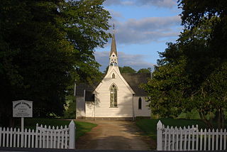
Putorino is a small farming settlement in northern Hawke's Bay, on the eastern side of New Zealand's North Island. It is located on State Highway 2 between Tutira and Mohaka, on the Hastings side of the border between Hastings and Wairoa.
Waikokopu is a small coastal settlement in the north of New Zealand's Hawke's Bay Region, where the Waikokopu stream forms a small tidal estuary between two prominent headlands. The name Waikokopu translates from Māori as "waters" (wai) of the "kokopu", the kokopu being any one of three species of small native fresh-water fish. Waikokopu is about 40 km east of Wairoa, the largest town in northern Hawke's Bay.
The Moeangiangi River is a river of the Hawke's Bay region of New Zealand's North Island. It flows east from hill country to the east of Lake Tutira to reach Hawke Bay 25 kilometres (16 mi) north of Napier.
The Nūhaka River is a river of the Gisborne and Hawke's Bay regions of New Zealand's North Island. It flows generally south from its sources in rough coastal hill country south of Gisborne, reaching the sea at Nūhaka, close to the northern end of Hawke Bay.
The Tahaenui River is a river of the Hawke's Bay region of New Zealand's North Island. It flows generally southeast to reach Hawke Bay five kilometres west of Nūhaka.

The Waikōau River is a river in southern Fiordland, New Zealand. Since 21 June 2019 the official name has been Waikōau River. Waikōau River North Branch has been the official name of a tributary, which joins the river about a kilometre from the sea, since 19 December 2019. Rising north of the Hump Ridge, it flows south-eastward into Te Waewae Bay.
The Esk River of Hawke's Bay, in the eastern North Island of New Zealand, one of two rivers of that name in the country, is one of Hawke's Bay's major rivers. It flows south from the slopes of Taraponui in the Maungaharuru Range before turning east to reach Hawke Bay 10 kilometres (6 mi) north of Napier. State Highway 5 follows the lower course of the river for several kilometres close to the settlement of Eskdale. The river is probably named after the Esk River in southern Scotland and north-west England.
The Waiaua River is a river of the Bay of Plenty Region of New Zealand's North Island. It flows generally northwest to reach the eastern end of the Bay of Plenty 10 kilometres (6 mi) east of Ōpōtiki.

The Waikari River is a river in the Hawke's Bay region of New Zealand's North Island. It flows generally east from its source at the northern end of the Maungaharuru Range passing the settlement of Putorino to reach Hawke Bay 25 kilometres southwest of Wairoa. The name Waikari comes from the Māori words wai meaning "water" and kari meaning "dig". The river was called Waikare until given an official name in 1941.
Kotemaori is a village and rural community located in the Wairoa District of the Hawke's Bay Region, in New Zealand's North Island. It is located between Raupunga and Putorino, to the west of Wairoa. The settlement itself lies immediately to the south of the highway.
Elsthorpe is a village in the Central Hawke's Bay District and Hawke's Bay Region of New Zealand's North Island. It is located east of Ōtāne, Waipawa and State Highway 2 and west of the east coast.
Te Awa is a suburb of the city of Napier, in the Hawke's Bay region of New Zealand's eastern North Island.
Omahu is a village in the Hastings District and Hawke's Bay Region of New Zealand's North Island. It is located on State Highway 50, north-west of Hastings on the north bank of the Ngaruroro River.
Waiaua or Lower Waiaua is a rural community in the Ōpōtiki District and Bay of Plenty Region of New Zealand's North Island, located around the lower part of the Waiaua River.
References
"Place name detail: Waihua River". New Zealand Gazetteer. New Zealand Geographic Board . Retrieved 12 July 2009.
- ↑ "1000 Māori place names". New Zealand Ministry for Culture and Heritage. 6 August 2019.
39°05′33″S177°17′10″E / 39.09252°S 177.28612°E