Related Research Articles

Anahola is a census-designated place (CDP) in Kauaʻi County, Hawaiʻi, United States. The population was 2,311 at the 2020 census, up from 1,932 at the 2000 census.

ʻEleʻele is a census-designated place (CDP) on the island of Kauaʻi in Kauaʻi County, Hawaiʻi, United States, with the ZIP code of 96705. Glass Beach, that is made of sea glass, is a local attraction. The population was 2,515 at the 2020 census, up from 2,040 at the 2000 census.
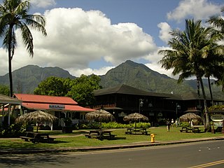
Hanalei is a census-designated place (CDP) in Kauaʻi County, Hawaii, United States. The population was estimated at 299 as of 2019. Hanalei means "lei making" in Hawaiian. Alternatively, the name Hanalei also means "crescent bay" and may be indicative of the shape of Hanalei Bay. Hanalei can also be translated as lei valley, referring to the rainbows that color the valley and encircle Hanalei like a wreath.

Hanamāʻulu is a census-designated place (CDP) in Kauaʻi County, Hawaiʻi, United States. It is the ancient birthplace of Kawelo, a member of Kauai's ruling family. The population was 4,994 at the 2020 census, up from 3,272 at the 2000 census.

Hanapepe or Hanapēpē is a historic, unincorporated community in Kauai County, Hawaii, United States. The name means "crushed bay" in Hawaiian, which may refer to landslides in the area. For statistical purposes, the United States Census Bureau has defined Hanapepe as a census-designated place (CDP). The population was 2,678 at the 2020 census, up from 2,153 at the 2000 census.

Kalāheo is an unincorporated community and census-designated place (CDP) in Kauaʻi County, island of Kauaʻi, Hawaiʻi, United States. The population was 4,996 at the 2020 census, up from 3,913 at the 2000 census.
Kalihiwai is a census-designated place (CDP) in Kauaʻi County, Hawaiʻi, United States. The population was 361 at the 2020 census.

Kekaha is a census-designated place (CDP) in Kauaʻi County, Hawaiʻi, United States. The population was 3,715 at the 2020 census, up from 3,175 at the 2000 census.

Kīlauea is an unincorporated community and census-designated place (CDP) in Kauaʻi County, Hawaii, United States. As of the 2020 census it had a population of 3,014.

Kōloa is an unincorporated community and census-designated place (CDP) in Kauaʻi County, Hawaiʻi, United States. The population was 2,231 at the 2020 census, up from 1,942 at the 2000 census. The first successful sugarcane plantation in the Hawaiian Islands was started here in 1835. It became a part of Grove Farm in 1948.

ʻŌmaʻo is a census-designated place (CDP) in Kauaʻi County, Hawaiʻi, United States. The population was 1,346 at the 2020 census.

Poʻipū is a census-designated place (CDP) in Kauaʻi County on the southern side of the island of Kauaʻi in the U.S. state of Hawaiʻi. The population was 1,299 at the 2020 census. The town features a group of high-end hotels, resorts and two main shopping centers.

Puhi is a census-designated place (CDP) in Kauaʻi County, Hawaiʻi, United States. The population was 3,380 at the 2020 census, up from 1,186 at the 2000 census.

Wailua is a census-designated place (CDP) in Kauaʻi County, Hawaiʻi, United States. The population was 2,359 at the 2020 census, up from 2,083 at the 2000 census.

Waimea Canyon, also known as the Grand Canyon of the Pacific, is a large canyon, approximately ten miles (16 km) long and up to 3,000 feet deep, located on the western side of Kauaʻi in the Hawaiian Islands of the United States. Waimea is Hawaiian for "reddish water", a reference to the erosion of the canyon's red soil. The canyon was formed by a deep incision of the Waimea River arising from the extreme rainfall on the island's central peak, Mount Waiʻaleʻale, among the wettest places on earth.

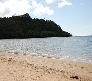
Hāʻena State Park is a state park on the north shore of the Hawaiian island of Kauaʻi. It is often called the "end of the road" and marks the endpoint of the Kuhio Highway. The park provides access to beaches, trails, and several ancient Hawaiian sites, including sea caves estimated to be more than 4,000 years old. Archaeological sites associated with the hula, including a heiau (shrine) dedicated to Laka, are above the park's beaches.

Kapaʻa is an unincorporated community and census-designated place (CDP) in Kauaʻi County, Hawaiʻi, United States. It is the most populous town in the island of Kauai, with a population of 11,652 as of the 2020 census, up from 9,471 at the 2000 census.
Anini Beach is a beach located on the north shore of Kauai, Hawaii. It is well known for its excellent windsurfing and views of the large coral reef that rings the island. Nearby waters range between four and 100 feet in depth, and the beach is known for strong currents. Anini Beach is dotted by expensive homes, one of which was used for the filming of Honeymoon in Vegas (1992).The calm and crystal-clear waters make it an excellent spot to explore vibrant coral reefs teeming with marine life.

Camp Naue YMCA is a 12-acre beachfront campground on the north shore of Kauai, Hawaii. It contains five bunkhouses (cabins), bathrooms, showers, a pavilion, a kitchen and a dining hall. It is used by visiting campers as well as local youth groups. The campground is located directly on Haena Beach. Naue literally means "to move" in Hawaiian.

Spouting Horn is a blowhole located on the southern coast of Kauai in the Koloa district. This area of Kauai is known for its crashing waves. These waves erode lava rocks on the coastline which can create narrow openings, as is the case with Spouting Horn. With every wave, water shoots upward when it is forced through an opening and creates a sound suggestive of hissing. The spray can shoot as high as 50 feet in the air. The original Hawaiian name was puhi, meaning blowhole. The Spouting Horn is a part of the Koloa Heritage Trail, a 10-mile trail in the Koloa district.
References
- ↑ Pukui, Mary Kawena. Place Names of Hawaii. University of Hawaii Press. ISBN 0-8248-0524-0.
- ↑ Pukui, Mary Kawena. Place Names of Hawaii. University of Hawaii Press. ISBN 0-8248-0524-0 [ page needed ]
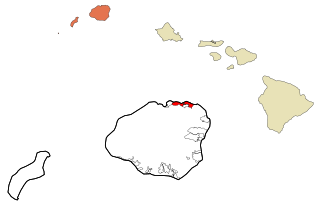
Islands, municipalities, and communities of Kauai County, Hawaii, United States | ||
|---|---|---|
| CDPs |  | |
| Other communities | ||
22°12′39″N159°32′36″W / 22.21083°N 159.54333°W
| Authority control databases: Geographic |
|---|
| | This Hawaiʻi state location article is a stub. You can help Wikipedia by expanding it. |