
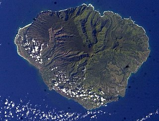
Niʻihau, anglicized as Niihau, is the westernmost main and seventh largest inhabited island in Hawaii. It is 17.5 miles (28.2 km) southwest of Kauaʻi across the Kaulakahi Channel. Its area is 69.5 square miles (180 km2). Several intermittent playa lakes provide wetland habitats for the Hawaiian coot, the Hawaiian stilt, and the Hawaiian duck. The island is designated as critical habitat for Brighamia insignis, an endemic and endangered species of Hawaiian lobelioid. The United States Census Bureau defines Niʻihau and the neighboring island and State Seabird Sanctuary of Lehua as Census Tract 410 of Kauai County, Hawaii. Its 2000 census population was 160, most of whom are native Hawaiians; its 2010 census population was 170. At the 2020 census, the population had fallen to 84.
Kauaʻi, anglicized as Kauai, is geologically the second-oldest of the main Hawaiian Islands. With an area of 562.3 square miles (1,456.4 km2), it is the fourth-largest of the islands and the 21st-largest island in the United States. Nicknamed the Garden Isle, Kauaʻi lies 73 miles (117 km) across the Kauaʻi Channel, northwest of Oʻahu. It is the site of Waimea Canyon State Park and the Na Pali Coast State Park.
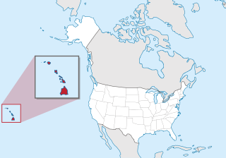
Kauaʻi County is a county in the U.S. state of Hawaiʻi. It consists of the islands of Kauaʻi, Niʻihau, Lehua, and Kaʻula. As of the 2020 Census the population was 73,298. The county seat is Līhuʻe.

Lihue or Līhuʻe is an unincorporated community, census-designated place (CDP) and the county seat of Kauai County, Hawaii, United States. Lihue is the second-largest town on the Hawaiian island of Kauaʻi after Kapaʻa. As of the 2010 census, the CDP had a population of 6,455, up from 5,694 at the 2000 census.

Kauaʻi Community College is a public community college in Līhuʻe, Hawaiʻi and it is the only institution of higher learning on the island. It is part of the University of Hawaiʻi system and is accredited by the Accrediting Commission for Community and Junior Colleges.

Hurricane Iniki was the most powerful hurricane to strike Hawaiʻi in recorded history. Forming on September 5, 1992, during the strong 1990–1995 El Niño, Iniki was one of eleven Central Pacific tropical cyclones during that season. It attained tropical storm status on September 8 and further intensified into a hurricane the next day. After turning north, Iniki struck the island of Kauaʻi on September 11 at peak intensity; it had winds of 145 mph and reached Category 4 status on the Saffir–Simpson hurricane scale. It had recorded wind gusts of 225 mph (362 km/h) as evidenced by an anemometer that was found blown into the forest during clean up. It was the first hurricane to hit the state since Hurricane Iwa in the 1982 season, and is the only known major hurricane to hit the state. Iniki dissipated on September 13 about halfway between Hawaii and Alaska.

Hurricane Iwa, taken from the Hawaiian language name for the frigatebird, was at the time the costliest hurricane to affect the state of Hawaiʻi. Iwa was the twenty-third tropical storm and the twelfth and final hurricane of the 1982 Pacific hurricane season. It developed from an active trough of low pressure near the equator on November 19. The storm moved erratically northward until becoming a hurricane on November 23 when it began accelerating to the northeast in response to strong upper-level flow from the north. Iwa passed within 25 miles of the island of Kauaʻi with peak winds of 90 mph (140 km/h) on November 23, and the next day it became extratropical to the northeast of the state.

KKCR-FM Kauaʻi Community Radio is a community radio station broadcasting a variety format including Hawaiian, jazz, blues, R&B, rock, reggae, classical and world artists as well as locally produced talk programs. Licensed to the Kekahu Foundation in Hanalei, Hawaii, United States, the station serves the island of Kauaʻi and parts of Oahu. The station is owned by the Kekahu Foundation, Inc.
Puʻuwai is an unincorporated community in Kauai County, Hawaii, United States, and the only settlement on the island of Niʻihau. It is at the western coast of the small island, and Native Hawaiians who live in this village speak the Niihau dialect of the Hawaiian language. The community lives as they did hundreds of years ago, and the modern amenities of life are extremely limited. Access to the town, as well as the whole island, is limited to Niʻihau residents; only official visitors and invited guests are permitted. Puʻuwai has a one-room schoolhouse.

Hurricane Dot of August 1959 was at its time the costliest tropical cyclone in Hawaiian history. Dot was first identified as a strong tropical storm southeast of Hawaiʻi on August 1. The storm was potentially a continuation of a previously unnamed tropical cyclone that was monitored west of the Baja California Peninsula from July 24–27, but was never confirmed due to a lack of ship reports. Dot was quick to intensify, reaching hurricane intensity six hours after naming. By August 3, Dot reached its peak intensity, with maximum sustained winds reaching 150 mph (240 km/h). Intensity leveled off afterwards as Dot tracked westward before making a curve towards the northwest on August 5, after which the hurricane weakened at a faster clip. Dot made landfall the next day on Kauai as a minimal hurricane before dissipating west of the Hawaiian Islands on August 8.

Route 50 is a 33-mile (53 km) road that stretches from Route 56 at the junction of Rice Street in Lihue to a point approximately 1/5 mile north of the northernmost entrance of the Pacific Missile Range Facility on the western shore of Kauai. It is the longest numbered road on the island of Kauaʻi and is named Kaumualiʻi Highway.

Route 560, or Kaua'i Belt Road-North Shore section, is a ten-mile (16 km) scenic road on the northern shore of the island of Kauaʻi in Hawaii. The entire belt road is signed as the Kuhio Highway. Hawaii Route 56 was once signed on this route before it was downgraded to become Hawaii Route 560 in the late 1960s. The Kuhio Highway is named after Jonah Kūhiō Kalaniana'ole, the second non-voting Congressional Delegate from territorial Hawaii.

There are two heritage railways in Kauai, the birthplace of Hawaiian railroading. It was added to the National Register of Historic Places on January 19, 1979.

Kawaikini is a shield volcano on the Hawaiian Island of Kauai and in Kauai County and measures 5,243 feet (1,598 m) in elevation. It is the summit of the island's inactive central shield volcano, Mount Waialeale. Other peaks on Kauai include: Waialeale, Namolokama Mountain, Kalalau Lookout, Keanapuka Mountain, Haupu and Nounou.
Paleontology in Hawaii refers to paleontological research occurring within or conducted by people from the U.S. state of Hawaii. The Hawaiian islands began to form as a result of volcanic activity about 5 million years ago. Due to their young age and igneous geology, the islands preserve very few fossils. Most such remains are creatures like relatively recent corals and molluscs that lived in the area when sea levels were higher than they are today. Overall the state has seen very little paleontological research within its borders. According to author Marian Murray, prior to the 1974 publication of the second edition to her book Hunting for Fossils most of the little research on Hawaii's fossils record had already gone out of print. She recommended that would-be amateur fossil hunters in Hawaii consult staff of a local museum for clues on where to hunt due to the rarity of fossils and the lack of easily accessible information on them.
Hāʻena is an unincorporated community and census-designated place on the island of Kauai in Kauai County, Hawaii, United States. Its population was 550 as of the 2020 census. The community is located on the north side of the island along Hawaii Route 560.


