Cumberland Furnace is an unincorporated community in Dickson County, Tennessee, United States. Cumberland Furnace is served by a U.S. Post Office, ZIP Code 37051.
Slidell is an unincorporated community in Wise County, Texas, United States. Slidell was named for John Slidell, a 19th-century U.S. Senator and C.S.A. diplomat.
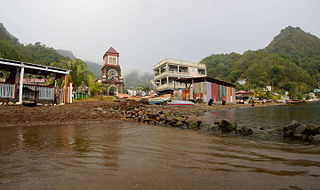
Soufrière is a village on the southwest coast of Dominica. It is the capital of Saint Mark Parish and has a population of 1,416 people.
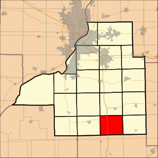
Boynton Township is located in Tazewell County, Illinois. As of the 2010 census, its population was 275 and it contained 94 housing units. Formed as Boyington Township in November, 1854, but the name was changed to Boynton on an unknown date.
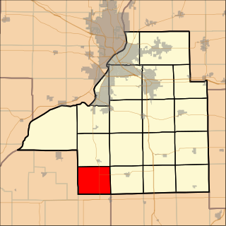
Malone Township is located in Tazewell County, Illinois. As of the 2010 census, its population was 220 and it contained 95 housing units. Malone Township formed from Delavan Township in November, 1854.

Mingo Cay is an island part of Central sub-district, in Saint John, United States Virgin Islands. It is located between Saint Thomas and Saint John.
Tunnels Mill is an unincorporated community in Accomack County, Virginia.
Adamów is a village in the administrative district of Gmina Opoczno, within Opoczno County, Łódź Voivodeship, in central Poland.
Accokeek Creek is a tidal tributary of Potomac Creek, itself a tributary of the Potomac River, in Stafford County, Virginia, United States. From it headwaters to its mouth, Accokeek Creek is 15.4 miles (24.8 km) in total length.
Shideler is an unincorporated community in Delaware County, Indiana, in the United States.

Jayhawk is an unincorporated community in El Dorado County, California. It is located 6.5 miles (10 km) southwest of Coloma, at an elevation of 1161 feet.
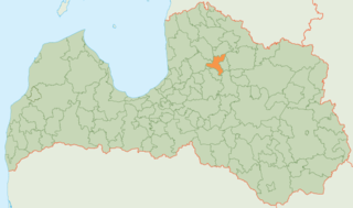
Priekuļi Municipality is a municipality in Vidzeme, Latvia. The municipality was formed in 2009 by merging Liepa parish, Mārsnēni parish, Priekuļi parish and Veselava parish the administrative centre being Priekuļi.

Tibužde is a village in the municipality of Vranje, Serbia. According to the 2002 census, the village has a population of 1243 people.

Plainville is a census-designated place (CDP) in Hamilton County, Ohio, United States. The population was 87 at the 2010 census, with 100% being Caucasian and 89.7% being over the age of 18.

Browndale is an unincorporated community in Clay County, Kansas, in the United States. Browndale is located at 39°21′35″N97°21′03″W.
Steamtown is an unincorporated community in Noble County, in the U.S. state of Ohio.
Hickory Hill is an unincorporated community in Cole County, in the U.S. state of Missouri.
Plattin Creek is a stream in northeastern St. Francois and Jefferson counties in the U.S. state of Missouri. It is a tributary of the Mississippi River.
Cheesetown is an unincorporated community in Franklin County, in the U.S. state of Pennsylvania.
Göktaş Dam Turkish: Göktaş Barajı) is a hydroelectric plant in Turkey.